
Previsiones:

Pronóstico Corto PlazoAlgo de llovizna, más pesada durante la noche de jueves. Warm (max 28°C el jueves por la mañana, min 25°C el jueves por la noche). Mayormente vientos frescos. | ||||||||||||||||||||||||
jueves 16 | viernes 17 | sábado 18 | ||||||||||||||||||||||
1 AM | 4 AM | 7 AM | 10 AM | 1 PM | 4 PM | 7 PM | 10 PM | 1 AM | 4 AM | 7 AM | 10 AM | 1 PM | 4 PM | 7 PM | 10 PM | 1 AM | 4 AM | 7 AM | 10 AM | 1 PM | 4 PM | 7 PM | 10 PM | |
Mapa de Altura de Olas |  | 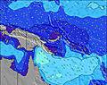 | 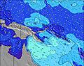 | 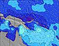 | 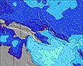 | 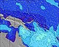 | 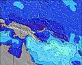 | 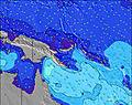 | 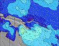 | |||||||||||||||
Oleaje Altura (m) Dirección Período (s) | SSE 8 | SSE 8 | SSE 8 | SSE 8 | SSE 8 | SSE 8 | SSE 8 | S 8 | SSE 8 | SSE 8 | SSE 8 | SSE 8 | SSE 8 | SSE 8 | SSE 8 | SSE 8 | S 8 | S 8 | SSE 8 | SSE 8 | SSE 8 | SSE 8 | SSE 7 | SSE 7 |
Gráfico Olas | ||||||||||||||||||||||||
300 | 395 | 556 | 533 | 520 | 450 | 406 | 346 | 308 | 280 | 280 | 324 | 373 | 383 | 350 | 350 | 341 | 294 | 251 | 207 | 202 | 226 | 220 | 220 | |
Viento (km/h) | ||||||||||||||||||||||||
Estado del Viento Viento de Mar Viento de Mar-Cruzado Cruzado Viento de Tierra-Cruzado Viento de Tierra Cristalino | on | on | on | on | on | on | on | on | on | on | on | on | on | on | on | on | on | on | on | on | on | on | on | on |
Marea alta | 3:26AM0.98m | 3:49AM0.93m | 4:01AM0.85m | |||||||||||||||||||||
Marea baja | 12:27PM0.00m | 12:32PM0.10m | 12:14PM0.18m | |||||||||||||||||||||
— | 5:58 | — | — | — | — | — | — | — | 5:58 | — | — | — | — | — | — | — | 5:58 | — | — | — | — | — | — | |
— | — | — | — | — | 5:52 | — | — | — | — | — | — | — | 5:52 | — | — | — | — | — | — | — | 5:52 | — | — | |
mm | — | — | — | — | — | — | — | — | — | 1 | — | — | — | — | — | — | — | — | — | — | — | — | — | — |
Temp. °C | 25 | 25 | 25 | 27 | 28 | 27 | 26 | 25 | 25 | 25 | 25 | 26 | 28 | 27 | 25 | 25 | 25 | 25 | 25 | 27 | 28 | 28 | 26 | 25 |
Enfriamiento °C | 24 | 23 | 23 | 25 | 25 | 25 | 25 | 25 | 25 | 25 | 24 | 24 | 25 | 24 | 23 | 23 | 24 | 24 | 25 | 25 | 26 | 26 | 25 | 24 |
Oleaje 1 Altura (m) Dirección Período (s) | E 8 | E 8 | E 8 | E 8 | E 9 | E 9 | E 9 | E 9 | E 9 | E 8 | E 8 | E 8 | E 9 | ESE 8 | ESE 9 | E 9 | E 8 | E 8 | E 8 | E 8 | E 8 | E 8 | E 9 | E 8 |
1 | 1 | 1 | 1 | 13 | 13 | 14 | 14 | 13 | 12 | 5 | 1 | 13 | 14 | 15 | 2 | 1 | 1 | 5 | 5 | 1 | 1 | 6 | 6 | |
Oleaje 2 Altura (m) Dirección Período (s) | — | — | — | — | ESE 7 | E 9 | — | E 9 | E 8 | ESE 8 | ESE 9 | E 11 | E 10 | — | — | S 13 | E 9 | E 9 | E 9 | E 9 | E 10 | E 10 | E 9 | E 9 |
— | — | — | — | 5 | 6 | — | 13 | 12 | 13 | 15 | 2 | 8 | — | — | 3 | 2 | 2 | 2 | 2 | 2 | 2 | 2 | 2 | |
Oleaje 3 Altura (m) Dirección Período (s) | ENE 9 | — | — | — | — | — | — | — | — | NE 9 | NE 10 | NE 10 | — | NE 9 | NE 9 | NE 9 | NE 9 | NE 9 | NE 9 | NE 9 | E 8 | S 8 | NE 9 | NE 9 |
8 | — | — | — | — | — | — | — | — | 3 | 4 | 4 | — | 3 | 3 | 3 | 3 | 3 | 3 | 3 | 33 | 35 | 3 | 3 | |
Olas de Viento Altura (m) Dirección Período (s) | SSE 8 | SSE 8 | SSE 8 | SSE 8 | SSE 8 | SSE 8 | SSE 8 | S 8 | SSE 8 | SSE 8 | SSE 8 | SSE 8 | SSE 8 | SSE 8 | SSE 8 | SSE 8 | S 8 | S 8 | SSE 8 | SSE 8 | SSE 8 | SSE 8 | SSE 7 | SSE 7 |
300 | 395 | 556 | 533 | 520 | 450 | 406 | 346 | 308 | 280 | 280 | 324 | 373 | 383 | 350 | 350 | 341 | 294 | 251 | 207 | 202 | 226 | 220 | 220 | |
Viento del Tierra o Mar Limpio más proximo | ||||||||||||||||||||||||
Distancia (km) | 2307 | 694 | 206 | 694 | 694 | 2371 | 2307 | 2145 | 770 | 2307 | 2307 | 2377 | 2377 | 206 | 206 | 206 | 2145 | 206 | 694 | 206 | 2305 | 206 | 2145 | 2145 |
Mejores Olas Previstas en New Britain and Duke of York | ||||||||||||||||||||||||
Mejores Olas Previstas en Papua New Guinea | ||||||||||||||||||||||||
Busca-Olas Global | ||||||||||||||||||||||||
- Map Icons:
 Break
Break Live Wave Height (m)
 Live Wind Speed (km/h)
 Surf Rating (10 Max)
 Ocean Swells (m)
- Wind Speed (km/h)
GRÁTIS! Un widget de Surf-Forecast.com para tu sitio
Este widget grátis de previsiones de surf y tiempo puede ser añadido a cualquier otro sitio y da un resumen de previsiones de olas para Raiven. Solo necesita cortar y pegar el código HTML de abajo en su web. Puede elegir preferencias de idioma y de unidades (métricas o imperiales) para convenir a los usuarios de su sitio. Clica aquí para obtener el código.
 Nearest