

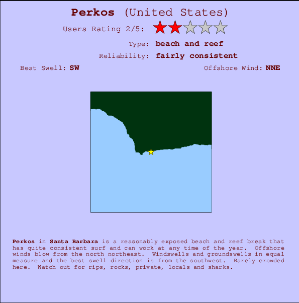
Perkos Surf Guide
Perkos in Santa Barbara is a fairly exposed beach and reef break that has fairly consistent surf and can work at any time of the year. The best wind direction is from the north northeast. Most of the surf here comes from groundswells and the ideal swell direction is from the southwest.. Even when there are waves, it's not likley to be crowded. Beware of rips, rocks, private, locals and sharks.
Perkos Spot Info
| Type: | Rating: | Reliability: | Todays Sea Temp*: |
|---|---|---|---|
| fairly consistent | 17.5°C*ocean temperature recorded from satellite |
Surfing Perkos:
The best conditions reported for surf at Perkos occur when a Southwest swell combines with an offshore wind direction from the North-northeast.

Energía de Olas (poder): 12 horas


Perkos Surf:
Thursday, 16 July 2026, 03:45 Local time| jueves 16 | ||||
| 2AM | 5AM | 8AM | 11AM | |
| Wave (m) | ||||
| Período (s) | 8 | 8 | 8 | 8 |
| Viento (km/h) | ||||
| Estado del Viento | cross- off |
cross- off |
cross- off |
cross- off |
- /breaks/Perkos/forecasts/latest
Perkos Surf Guide
Perkos in Santa Barbara is a fairly exposed beach and reef break that has fairly consistent surf and can work at any time of the year. The best wind direction is from the north northeast. Most of the surf here comes from groundswells and the ideal swell direction is from the southwest.. Even when there are waves, it's not likley to be crowded. Beware of rips, rocks, private, locals and sharks.
Perkos Spot Info
Type: Rating: Reliability: Todays Sea Temp*:  Beach and reef
 2
2fairly consistent 17.5°C*ocean temperature recorded from satelliteSurfing Perkos:
The best conditions reported for surf at Perkos occur when a Southwest swell combines with an offshore wind direction from the North-northeast.
Energía de Olas (poder): 12 horas
Usa la barra de navegación de arriba para ver la temperatura del mar en Perkos, fotografías Perkos, previsiones detalladas de olas para Perkos, vientos y previsión del tiempo, webcams para Perkos, viento actual desde estaciones meteorológicas en CAL - Santa Barbara y predicciones de marea para Perkos. Las mapas de olas para United States enseñarán un mapa grande de United States y los mares que rodean. Los mapas de olas pueden ser animadas para mostrar diferentes componentes de olas, la altura de ola, la energía de ola, el período, junto con previsiones de viento y del tiempo. Previsiones actuales del tiempo y del estado del mar provienen de boyas marinas de United States, del barcos que transitan en la zona y de estaciones meteorológicas costeras. Cada página de previsiones tiene un Busca-Olas Regional y Global para localizar las mejores condiciones para surfear en el área de Perkos.
Perkos Surf:
Thursday, 16 July 2026, 03:45 Local timejueves 16 2AM 5AM 8AM 11AM Wave (m) Período (s) 8 8 8 8 Viento (km/h) Estado del Viento cross-
offcross-
offcross-
offcross-
off- /breaks/Perkos/forecasts/latest
- /breaks/Perkos/forecasts/latest/six_day
Perkos Surf Guide
Perkos in Santa Barbara is a fairly exposed beach and reef break that has fairly consistent surf and can work at any time of the year. The best wind direction is from the north northeast. Most of the surf here comes from groundswells and the ideal swell direction is from the southwest.. Even when there are waves, it's not likley to be crowded. Beware of rips, rocks, private, locals and sharks.
Perkos Spot Info
Type: Rating: Reliability: Todays Sea Temp*: Beach and reef2fairly consistent 17.5°C*ocean temperature recorded from satelliteSurfing Perkos:
The best conditions reported for surf at Perkos occur when a Southwest swell combines with an offshore wind direction from the North-northeast.
Energía de Olas (poder): 12 horas
Usa la barra de navegación de arriba para ver la temperatura del mar en Perkos, fotografías Perkos, previsiones detalladas de olas para Perkos, vientos y previsión del tiempo, webcams para Perkos, viento actual desde estaciones meteorológicas en CAL - Santa Barbara y predicciones de marea para Perkos. Las mapas de olas para United States enseñarán un mapa grande de United States y los mares que rodean. Los mapas de olas pueden ser animadas para mostrar diferentes componentes de olas, la altura de ola, la energía de ola, el período, junto con previsiones de viento y del tiempo. Previsiones actuales del tiempo y del estado del mar provienen de boyas marinas de United States, del barcos que transitan en la zona y de estaciones meteorológicas costeras. Cada página de previsiones tiene un Busca-Olas Regional y Global para localizar las mejores condiciones para surfear en el área de Perkos.
Perkos Surf:
Thursday, 16 July 2026, 03:45 Local timejueves 16 2AM 5AM 8AM 11AM Wave (m) Período (s) 8 8 8 8 Viento (km/h) Estado del Viento cross-
offcross-
offcross-
offcross-
off- /breaks/Perkos/forecasts/latest
Perkos Surf Guide
Perkos in Santa Barbara is a fairly exposed beach and reef break that has fairly consistent surf and can work at any time of the year. The best wind direction is from the north northeast. Most of the surf here comes from groundswells and the ideal swell direction is from the southwest.. Even when there are waves, it's not likley to be crowded. Beware of rips, rocks, private, locals and sharks.
Perkos Spot Info
Type: Rating: Reliability: Todays Sea Temp*: Beach and reef2fairly consistent 17.5°C*ocean temperature recorded from satelliteSurfing Perkos:
The best conditions reported for surf at Perkos occur when a Southwest swell combines with an offshore wind direction from the North-northeast.
Energía de Olas (poder): 12 horas
Usa la barra de navegación de arriba para ver la temperatura del mar en Perkos, fotografías Perkos, previsiones detalladas de olas para Perkos, vientos y previsión del tiempo, webcams para Perkos, viento actual desde estaciones meteorológicas en CAL - Santa Barbara y predicciones de marea para Perkos. Las mapas de olas para United States enseñarán un mapa grande de United States y los mares que rodean. Los mapas de olas pueden ser animadas para mostrar diferentes componentes de olas, la altura de ola, la energía de ola, el período, junto con previsiones de viento y del tiempo. Previsiones actuales del tiempo y del estado del mar provienen de boyas marinas de United States, del barcos que transitan en la zona y de estaciones meteorológicas costeras. Cada página de previsiones tiene un Busca-Olas Regional y Global para localizar las mejores condiciones para surfear en el área de Perkos.
Perkos Surf:
Thursday, 16 July 2026, 03:45 Local timejueves 16 2AM 5AM 8AM 11AM Wave (m) Período (s) 8 8 8 8 Viento (km/h) Estado del Viento cross-
offcross-
offcross-
offcross-
offTide Times:
Para Cojo, a %{dist} %{km} de %{location}.
PROXIMA ES A LAS (hora local) quedan marea alta marea baja Perkos Tide Times and Tide Chart
Live Weather:
At Santa Barbara Buoy, 20 km from Perkos.
strong winds from the NW
(km/h)Air temperature
-°CBuoy Data:
At Santa Barbara Buoy, 12 miles from Perkos.
10PM 11PM 12AM 1AM Antigüedad de datos 4 hr 3 hr 2 hr 1 hr Altura de Olas (m) 


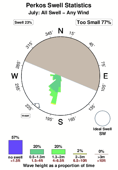
Período Dominante (s) 7 - 8 8 Overall Perkos Surf Consistency and Wind Distribution in julio
Fotos de Surf
de la galeríaContornos: Carreteras y Ríos: Selecciona un spot desde el menú 


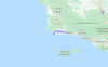
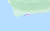
Usa este mapa para navegar hacia las playas de surf de CAL - Santa Barbara y estaciones de marea cercanas de Perkos
Spots de Surf más cercanos a Perkos:
(Clica la ubicación para más detalles)- Closest spot1 mi
- Second closest spot2 mi
- Third closest spot5 mi
- Fourth closest spot5 mi
- Fifth closest spot6 mi
Boyas marinas más cercanas a Perkos:
- Closest Boya Marinas12 mi
- Second closest Boya Marinas20 mi
- Third closest Boya Marinas36 mi
- Fourth closest Boya Marinas36 mi
- Fifth closest Boya Marinas38 mi
Estaciones de marea más cercanas a Perkos:
- Closest estación de mareaGaviota12 mi
- Second closest estación de mareaOil Platform Harvest (Topex Project)14 mi
- Third closest estación de mareaPoint Arguello16 mi
- Fourth closest estación de mareaCuyler Harbor, San Miguel Island28 mi
- Fifth closest estación de mareaIsla Vista32 mi
Airports
- The closest passenger airport to Perkos is Vandenberg Afb (Lompoc) Airport (VBG) in USA, 34 km (21 miles) away (directly).
- The second nearest airport to Perkos is Point Mugu Nas Airport (NTD), also in USA, 125 km (78 miles) away.
- Third is Meadows Fld (Bakersfield) Airport (BFL) in USA, 166 km (103 miles) away.
- Burbank Glendale Pasadena Airport (BUR) in USA is 192 km (119 miles) away.
- Los Angeles International Airport (LAX), also in USA is the fifth nearest airport to Perkos and is 194 km (120 miles) away.
- /breaks/Perkos/forecasts/latest


 Nearest