
Previsiones:

Pronóstico Corto PlazoFuerte lluvia (totál 39mm), más pesada durante la tarde de domingo. Warm (max 28°C el domingo por la mañana, min 26°C el domingo por la noche). El viento será generalmente ligero. | |||||||||||||||||||||
dom 2 | lunes 3 | martes 4 | |||||||||||||||||||
10 AM | 1 PM | 4 PM | 7 PM | 10 PM | 1 AM | 4 AM | 7 AM | 10 AM | 1 PM | 4 PM | 7 PM | 10 PM | 1 AM | 4 AM | 7 AM | 10 AM | 1 PM | 4 PM | 7 PM | 10 PM | |
Mapa de Altura de Olas |  |  |  | 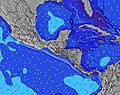 |  |  | 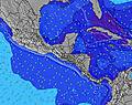 |  | |||||||||||||
Oleaje Altura (m) Dirección Período (s) | NE 9 | NE 9 | NE 8 | NE 8 | NE 8 | NE 8 | NE 8 | NE 8 | NE 8 | NE 8 | NE 8 | NE 8 | ENE 9 | ENE 9 | NE 9 | NE 9 | NE 9 | NE 9 | NE 9 | NE 9 | NE 9 |
Gráfico Olas | |||||||||||||||||||||
323 | 281 | 279 | 222 | 222 | 191 | 191 | 196 | 180 | 211 | 211 | 211 | 252 | 264 | 338 | 424 | 424 | 424 | 415 | 365 | 349 | |
Viento (km/h) | |||||||||||||||||||||
Estado del Viento Viento de Mar Viento de Mar-Cruzado Cruzado Viento de Tierra-Cruzado Viento de Tierra Cristalino | cross-off | cross-off | cross-off | off | cross-off | cross-off | off | off | cross-off | cross-off | cross-off | cross-off | cross-off | cross-off | cross-off | off | cross-off | cross-off | cross-off | cross-off | cross-off |
Marea alta | 5:19PM0.22m | 3:48AM0.18m | 5:37PM0.29m | 4:51AM0.14m | 6:05PM0.35m | ||||||||||||||||
Marea baja | 10:16AM-0.01m | 11:01PM0.12m | 10:27AM-0.01m | 00:24AM0.07m | 10:43AM-0.01m | ||||||||||||||||
6:18 | — | — | — | — | — | 6:18 | — | — | — | — | — | — | — | 6:18 | — | — | — | — | — | — | |
— | — | 6:50 | — | — | — | — | — | — | — | 6:50 | — | — | — | — | — | — | — | 6:50 | — | — | |
mm | 2 | — | — | 5 | — | — | 1 | 4 | 4 | 1 | 1 | 3 | 1 | — | 3 | 2 | 1 | 1 | — | 3 | 2 |
Temp. °C | 27 | 28 | 27 | 27 | 27 | 27 | 27 | 26 | 27 | 28 | 28 | 28 | 27 | 27 | 27 | 26 | 27 | 28 | 28 | 27 | 27 |
Enfriamiento °C | 29 | 29 | 28 | 31 | 30 | 30 | 30 | 29 | 29 | 30 | 30 | 31 | 30 | 29 | 29 | 27 | 29 | 29 | 29 | 29 | 30 |
Oleaje 1 Altura (m) Dirección Período (s) | NE 9 | NE 9 | NE 8 | NE 8 | NE 8 | NE 8 | NE 8 | NE 8 | NE 8 | NE 8 | NE 8 | NE 8 | ENE 9 | ENE 9 | NE 9 | NE 9 | NE 9 | NE 9 | NE 9 | NE 9 | NE 9 |
323 | 281 | 279 | 222 | 222 | 191 | 191 | 196 | 180 | 211 | 211 | 211 | 252 | 264 | 338 | 424 | 424 | 424 | 415 | 365 | 349 | |
Oleaje 2 Altura (m) Dirección Período (s) | — | — | — | — | — | — | — | — | — | — | — | — | — | — | — | — | — | — | — | — | — |
— | — | — | — | — | — | — | — | — | — | — | — | — | — | — | — | — | — | — | — | — | |
Oleaje 3 Altura (m) Dirección Período (s) | — | — | — | — | — | — | — | — | — | — | — | — | — | — | — | — | — | — | — | — | — |
— | — | — | — | — | — | — | — | — | — | — | — | — | — | — | — | — | — | — | — | — | |
Olas de Viento Altura (m) Dirección Período (s) | — | — | — | — | — | — | — | — | — | — | — | — | — | — | — | — | NW 3 | — | — | WNW 3 | — |
— | — | — | — | — | — | — | — | — | — | — | — | — | — | — | — | 2 | — | — | 1 | — | |
Viento del Tierra o Mar Limpio más proximo | |||||||||||||||||||||
Distancia (km) | 17 | 17 | 17 | 17 | 17 | 0 | 0 | 0 | 17 | 0 | 0 | 3 | 17 | 0 | 0 | 0 | 0 | 0 | 17 | 93 | 93 |
Mejores Olas Previstas en Bocas del Toro | |||||||||||||||||||||
Mejores Olas Previstas en Panama | |||||||||||||||||||||
Busca-Olas Global | |||||||||||||||||||||
- Map Icons:
 Break
Break Live Wave Height (m)
 Live Wind Speed (km/h)
 Surf Rating (10 Max)
 Ocean Swells (m)
- Wind Speed (km/h)
GRÁTIS! Un widget de Surf-Forecast.com para tu sitio
Este widget grátis de previsiones de surf y tiempo puede ser añadido a cualquier otro sitio y da un resumen de previsiones de olas para Paunch Reef. Solo necesita cortar y pegar el código HTML de abajo en su web. Puede elegir preferencias de idioma y de unidades (métricas o imperiales) para convenir a los usuarios de su sitio. Clica aquí para obtener el código.
 Nearest