
Previsiones:

Pronóstico Corto PlazoLluvia ligera (totál 6mm), cayendo mayormente el lunes por la noche. Warm (max 27°C el martes por la tarde, min 20°C el lunes por la noche). Vientos decreciente (casi tempestad desde el SSO el lunes por la mañana, Vientos ligeros desde el SSO por la tarde de martes). | |||||||||||||||||||||||
domingo 2 | lunes 3 | martes 4 | |||||||||||||||||||||
5 AM | 8 AM | 11 AM | 2 PM | 5 PM | 8 PM | 11 PM | 2 AM | 5 AM | 8 AM | 11 AM | 2 PM | 5 PM | 8 PM | 11 PM | 2 AM | 5 AM | 8 AM | 11 AM | 2 PM | 5 PM | 8 PM | 11 PM | |
Mapa de Altura de Olas |  | 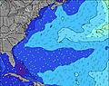 | 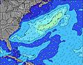 | 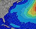 | 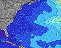 | 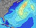 | 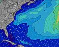 | 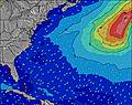 | 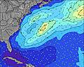 | ||||||||||||||
Oleaje Altura (m) Dirección Período (s) | SE 7 | ESE 9 | SE 7 | E 5 | ESE 9 | SE 7 | ESE 8 | SE 7 | SE 7 | E 8 | E 8 | E 8 | E 8 | E 8 | E 8 | E 8 | NW 4 | NNW 4 | NW 3 | E 9 | E 9 | SE 7 | SE 7 |
Gráfico Olas | |||||||||||||||||||||||
8 | 8 | 17 | 1 | 8 | 7 | 7 | 7 | 7 | 1 | 1 | 1 | 1 | 1 | 1 | 1 | 9 | 5 | 3 | 2 | 2 | 16 | 26 | |
Viento (km/h) | |||||||||||||||||||||||
Estado del Viento Viento de Mar Viento de Mar-Cruzado Cruzado Viento de Tierra-Cruzado Viento de Tierra Cristalino | cross-off | cross-off | cross-off | cross-off | cross-off | cross-off | cross-off | cross-off | cross-off | cross-off | off | off | off | off | cross-off | cross-off | cross-off | cross-off | off | off | off | off | off |
Marea alta | 2:24AM2.48m | 2:52PM2.39m | 3:06AM2.44m | 3:32PM2.44m | 3:51AM2.38m | 4:15PM2.48m | |||||||||||||||||
Marea baja | 8:39AM0.02m | 8:57PM0.14m | 9:19AM0.04m | 9:43PM0.12m | 10:02AM0.08m | 10:32PM0.11m | |||||||||||||||||
5:33 | — | — | — | — | — | — | — | 5:35 | — | — | — | — | — | — | — | 5:35 | — | — | — | — | — | — | |
— | — | — | — | 7:58 | — | — | — | — | — | — | — | 7:55 | — | — | — | — | — | — | — | 7:54 | — | — | |
mm | — | — | — | — | — | — | — | — | — | — | 2 | 1 | — | — | 3 | — | — | — | — | — | — | — | — |
Temp. °C | 22 | 22 | 24 | 25 | 24 | 23 | 23 | 23 | 23 | 24 | 23 | 24 | 24 | 23 | 22 | 20 | 20 | 21 | 24 | 27 | 27 | 25 | 25 |
Enfriamiento °C | 22 | 22 | 24 | 24 | 22 | 23 | 23 | 23 | 22 | 22 | 17 | 19 | 19 | 19 | 21 | 17 | 16 | 17 | 21 | 25 | 25 | 19 | 21 |
Oleaje 1 Altura (m) Dirección Período (s) | SE 7 | SE 7 | SE 7 | SE 7 | ESE 9 | SE 7 | ESE 8 | SE 7 | SE 7 | E 8 | E 8 | E 8 | E 8 | E 8 | E 8 | S 8 | SSE 8 | SSE 8 | SSE 8 | SSE 8 | SSE 8 | SE 7 | SE 7 |
7 | 12 | 17 | 13 | 8 | 7 | 7 | 7 | 7 | 1 | 1 | 1 | 1 | 1 | 1 | 140 | 101 | 80 | 61 | 44 | 42 | 16 | 26 | |
Oleaje 2 Altura (m) Dirección Período (s) | ESE 9 | ESE 9 | S 8 | E 5 | E 5 | ESE 9 | E 9 | E 9 | SE 9 | — | — | — | — | — | — | E 8 | E 8 | E 9 | NW 3 | NNW 3 | — | S 8 | E 10 |
8 | 8 | 1 | 1 | 1 | 7 | 2 | 1 | 3 | — | — | — | — | — | — | 1 | 1 | 2 | 3 | 1 | — | 4 | 2 | |
Oleaje 3 Altura (m) Dirección Período (s) | S 8 | S 8 | E 5 | E 5 | E 9 | E 9 | — | E 8 | E 8 | — | — | — | — | — | — | — | E 9 | E 9 | E 9 | E 9 | E 9 | E 9 | E 8 |
1 | 1 | 1 | 1 | 2 | 2 | — | 1 | 1 | — | — | — | — | — | — | — | 2 | 2 | 2 | 2 | 2 | 1 | 1 | |
Olas de Viento Altura (m) Dirección Período (s) | SSW 4 | SSW 3 | S 3 | S 4 | S 4 | S 4 | SSE 4 | SSE 4 | SSE 4 | S 5 | S 6 | S 7 | S 6 | S 8 | S 8 | NW 3 | NW 4 | NNW 4 | — | — | SSW 3 | SSW 3 | SW 3 |
7 | 4 | 5 | 9 | 14 | 10 | 11 | 17 | 24 | 73 | 246 | 342 | 275 | 412 | 291 | 5 | 9 | 5 | — | — | 2 | 9 | 5 | |
Viento del Tierra o Mar Limpio más proximo | |||||||||||||||||||||||
Distancia (km) | 474 | 607 | 1829 | 1829 | 1822 | 1696 | 1332 | 1332 | 1696 | 1228 | 373 | 373 | 374 | 56 | 9 | 9 | 9 | 8 | 8 | 8 | 148 | 138 | 138 |
Mejores Olas Previstas en Massachusetts | |||||||||||||||||||||||
Mejores Olas Previstas en United States | |||||||||||||||||||||||
Busca-Olas Global | |||||||||||||||||||||||
- Map Icons:
 Break
Break Live Wave Height (m)
 Live Wind Speed (km/h)
 Surf Rating (10 Max)
 Ocean Swells (m)
- Wind Speed (km/h)
GRÁTIS! Un widget de Surf-Forecast.com para tu sitio
Este widget grátis de previsiones de surf y tiempo puede ser añadido a cualquier otro sitio y da un resumen de previsiones de olas para Longnook Beach. Solo necesita cortar y pegar el código HTML de abajo en su web. Puede elegir preferencias de idioma y de unidades (métricas o imperiales) para convenir a los usuarios de su sitio. Clica aquí para obtener el código.
 Nearest