

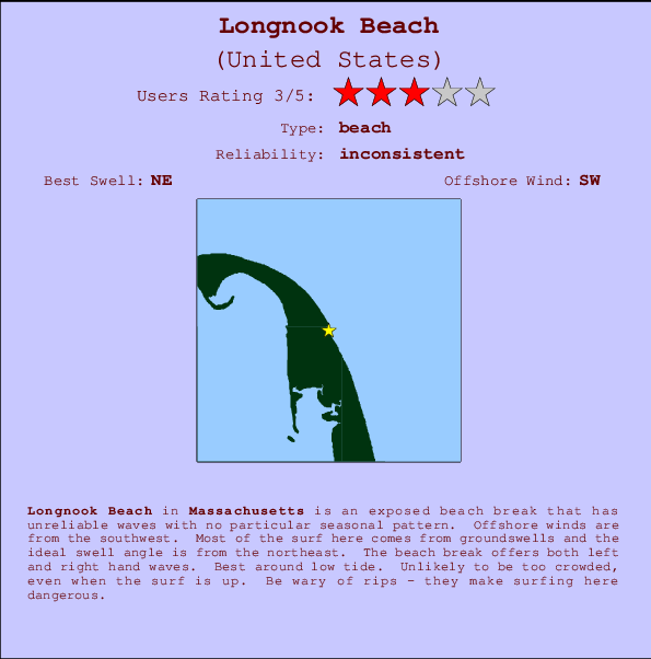
Longnook Beach Surf Guide
Longnook Beach in Massachusetts is an exposed beach break that only works once in a while with no particular seasonal pattern. The best wind direction is from the southwest. Groundswells and windswells are equally likely and the ideal swell direction is from the northeast. The beach break provides left and right handers. Best around low tide. Rarely crowded here. Surfing here means negotiating dangerous rips.
Longnook Beach Spot Info
| Type: | Rating: | Reliability: | Todays Sea Temp*: |
|---|---|---|---|
| inconsistent | 18.1°C*ocean temperature recorded from satellite |
Surfing Longnook Beach:
The best conditions reported for surf at Longnook Beach occur when a Northeast swell combines with an offshore wind direction from the Southwest.
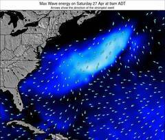
Energía de Olas (poder): 12 horas

Longnook Beach Surf:
Tuesday, 21 July 2026, 22:06 Local time| mar | miércoles 22 | |||
| 11PM | 2AM | 5AM | 8AM | |
| Wave (m) | ||||
| Período (s) | 11 | 11 | - | 11 |
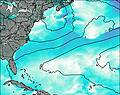
| Viento (km/h) | ||||
| Estado del Viento | cross- off |
cross- off |
off | off |
- /breaks/Longnook-Beach/forecasts/latest
Longnook Beach Surf Guide
Longnook Beach in Massachusetts is an exposed beach break that only works once in a while with no particular seasonal pattern. The best wind direction is from the southwest. Groundswells and windswells are equally likely and the ideal swell direction is from the northeast. The beach break provides left and right handers. Best around low tide. Rarely crowded here. Surfing here means negotiating dangerous rips.
Longnook Beach Spot Info
Type: Rating: Reliability: Todays Sea Temp*:  Beach
Beach 3
3inconsistent 18.1°C*ocean temperature recorded from satelliteSurfing Longnook Beach:
The best conditions reported for surf at Longnook Beach occur when a Northeast swell combines with an offshore wind direction from the Southwest.
Energía de Olas (poder): 12 horas
Usa la barra de navegación de arriba para ver la temperatura del mar en Longnook Beach, fotografías Longnook Beach, previsiones detalladas de olas para Longnook Beach, vientos y previsión del tiempo, webcams para Longnook Beach, viento actual desde estaciones meteorológicas en Massachusetts y predicciones de marea para Longnook Beach. Las mapas de olas para United States enseñarán un mapa grande de United States y los mares que rodean. Los mapas de olas pueden ser animadas para mostrar diferentes componentes de olas, la altura de ola, la energía de ola, el período, junto con previsiones de viento y del tiempo. Previsiones actuales del tiempo y del estado del mar provienen de boyas marinas de United States, del barcos que transitan en la zona y de estaciones meteorológicas costeras. Cada página de previsiones tiene un Busca-Olas Regional y Global para localizar las mejores condiciones para surfear en el área de Longnook Beach.
Longnook Beach Surf:
Tuesday, 21 July 2026, 22:06 Local timemar miércoles 22 11PM 2AM 5AM 8AM Wave (m) Período (s) 11 11 - 11 Viento (km/h) Estado del Viento cross-
offcross-
offoff off - /breaks/Longnook-Beach/forecasts/latest
- /breaks/Longnook-Beach/forecasts/latest/six_day
Longnook Beach Surf Guide
Longnook Beach in Massachusetts is an exposed beach break that only works once in a while with no particular seasonal pattern. The best wind direction is from the southwest. Groundswells and windswells are equally likely and the ideal swell direction is from the northeast. The beach break provides left and right handers. Best around low tide. Rarely crowded here. Surfing here means negotiating dangerous rips.
Longnook Beach Spot Info
Type: Rating: Reliability: Todays Sea Temp*: Beach3inconsistent 18.1°C*ocean temperature recorded from satelliteSurfing Longnook Beach:
The best conditions reported for surf at Longnook Beach occur when a Northeast swell combines with an offshore wind direction from the Southwest.
Energía de Olas (poder): 12 horas
Usa la barra de navegación de arriba para ver la temperatura del mar en Longnook Beach, fotografías Longnook Beach, previsiones detalladas de olas para Longnook Beach, vientos y previsión del tiempo, webcams para Longnook Beach, viento actual desde estaciones meteorológicas en Massachusetts y predicciones de marea para Longnook Beach. Las mapas de olas para United States enseñarán un mapa grande de United States y los mares que rodean. Los mapas de olas pueden ser animadas para mostrar diferentes componentes de olas, la altura de ola, la energía de ola, el período, junto con previsiones de viento y del tiempo. Previsiones actuales del tiempo y del estado del mar provienen de boyas marinas de United States, del barcos que transitan en la zona y de estaciones meteorológicas costeras. Cada página de previsiones tiene un Busca-Olas Regional y Global para localizar las mejores condiciones para surfear en el área de Longnook Beach.
Longnook Beach Surf:
Tuesday, 21 July 2026, 22:06 Local timemar miércoles 22 11PM 2AM 5AM 8AM Wave (m) Período (s) 11 11 - 11 Viento (km/h) Estado del Viento cross-
offcross-
offoff off - /breaks/Longnook-Beach/forecasts/latest
Longnook Beach Surf Guide
Longnook Beach in Massachusetts is an exposed beach break that only works once in a while with no particular seasonal pattern. The best wind direction is from the southwest. Groundswells and windswells are equally likely and the ideal swell direction is from the northeast. The beach break provides left and right handers. Best around low tide. Rarely crowded here. Surfing here means negotiating dangerous rips.
Longnook Beach Spot Info
Type: Rating: Reliability: Todays Sea Temp*: Beach3inconsistent 18.1°C*ocean temperature recorded from satelliteSurfing Longnook Beach:
The best conditions reported for surf at Longnook Beach occur when a Northeast swell combines with an offshore wind direction from the Southwest.
Energía de Olas (poder): 12 horas
Usa la barra de navegación de arriba para ver la temperatura del mar en Longnook Beach, fotografías Longnook Beach, previsiones detalladas de olas para Longnook Beach, vientos y previsión del tiempo, webcams para Longnook Beach, viento actual desde estaciones meteorológicas en Massachusetts y predicciones de marea para Longnook Beach. Las mapas de olas para United States enseñarán un mapa grande de United States y los mares que rodean. Los mapas de olas pueden ser animadas para mostrar diferentes componentes de olas, la altura de ola, la energía de ola, el período, junto con previsiones de viento y del tiempo. Previsiones actuales del tiempo y del estado del mar provienen de boyas marinas de United States, del barcos que transitan en la zona y de estaciones meteorológicas costeras. Cada página de previsiones tiene un Busca-Olas Regional y Global para localizar las mejores condiciones para surfear en el área de Longnook Beach.
Longnook Beach Surf:
Tuesday, 21 July 2026, 22:06 Local timemar miércoles 22 11PM 2AM 5AM 8AM Wave (m) Período (s) 11 11 - 11 Viento (km/h) Estado del Viento cross-
offcross-
offoff off Tide Times:
Para Cape Cod Lighthouse, SE of, Cape Cod, Massachusetts, a %{dist} %{km} de %{location}.
PROXIMA ES A LAS (hora local) quedan marea alta marea baja Longnook Beach Tide Times and Tide Chart
Live Weather:
At lightning 11km WSW of Wellfleet, 16 km from Longnook Beach.

ThunderstormAir temperature
°CCurrent weather near Longnook Beach
Buoy Data:
At Cape Cod Bay, MA, 19 miles from Longnook Beach.
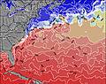
5PM 6PM 7PM 8PM Antigüedad de datos 4 hr 3 hr 2 hr 1 hr Altura de Olas (m) 


Período Dominante (s) 3 3 3 3 Overall Longnook Beach Surf Consistency and Wind Distribution in julio


Wind stats for Longnook Beach: see the variation in direction and stength by month.
Fotos de Surf
de la galeríaContornos: Carreteras y Ríos: Selecciona un spot desde el menú 


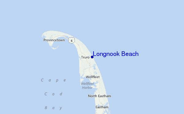
Usa este mapa para navegar hacia las playas de surf de Massachusetts y estaciones de marea cercanas de Longnook Beach
Spots de Surf más cercanos a Longnook Beach:
(Clica la ubicación para más detalles)- Closest spot1 mi
- Second closest spot3 mi
- Third closest spot5 mi
- Fourth closest spot6 mi
- Fifth closest spot7 mi
Boyas marinas más cercanas a Longnook Beach:
- Closest Boya Marinas19 mi
- Second closest Boya Marinas39 mi
- Third closest Boya Marinas40 mi
- Fourth closest Boya Marinas46 mi
- Fifth closest Boya Marinas56 mi
Estaciones de marea más cercanas a Longnook Beach:
- Closest estación de mareaCape Cod Lighthouse, SE of, Cape Cod1 mi
- Second closest estación de mareaWellfleet, Cape Cod Bay4 mi
- Third closest estación de mareaWellfleet6 mi
- Fourth closest estación de mareaProvincetown9 mi
- Fifth closest estación de mareaEastham12 mi
Airports
- The closest passenger airport to Longnook Beach is Otis Angb (Falmouth) Airport (FMH) in USA, 56 km (35 miles) away (directly).
- The second nearest airport to Longnook Beach is Nantucket Mem Airport (ACK), also in USA, 83 km (52 miles) away.
- Third is General Edward Lawrence Logan International (Boston) Airport (BOS) in USA, 91 km (57 miles) away.
- Laurence G Hanscom Fld (Bedford) Airport (BED) in USA is 117 km (73 miles) away.
- Theodore Francis Green State (Providence) Airport (PVD), also in USA is the fifth nearest airport to Longnook Beach and is 120 km (75 miles) away.
- /breaks/Longnook-Beach/forecasts/latest

 Nearest