
Previsiones:

Pronóstico Corto PlazoFuerte lluvia (totál 31mm), más pesada durante la noche de martes. Warm (max 29°C el lunes por la tarde, min 25°C el lunes por la noche). El viento será generalmente ligero. | ||||||||||||||||||||
lun 3 | martes 4 | miércoles 5 | ||||||||||||||||||
1 PM | 4 PM | 7 PM | 10 PM | 1 AM | 4 AM | 7 AM | 10 AM | 1 PM | 4 PM | 7 PM | 10 PM | 1 AM | 4 AM | 7 AM | 10 AM | 1 PM | 4 PM | 7 PM | 10 PM | |
Mapa de Altura de Olas |  | 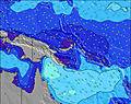 | 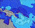 | 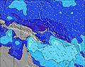 | 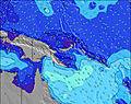 | 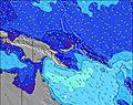 | 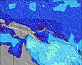 | 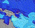 | ||||||||||||
Oleaje Altura (m) Dirección Período (s) | NE 14 | NE 14 | NE 14 | NE 13 | NE 13 | NE 14 | NE 13 | NE 14 | NE 14 | NE 14 | NE 14 | NE 14 | NE 14 | NNE 14 | NE 14 | NNE 14 | NNE 14 | NNE 13 | NNE 13 | NNE 13 |
Gráfico Olas | ||||||||||||||||||||
251 | 127 | 184 | 176 | 176 | 195 | 103 | 167 | 206 | 197 | 189 | 191 | 206 | 264 | 211 | 264 | 243 | 229 | 201 | 198 | |
Viento (km/h) | ||||||||||||||||||||
Estado del Viento Viento de Mar Viento de Mar-Cruzado Cruzado Viento de Tierra-Cruzado Viento de Tierra Cristalino | cross | cross-on | cross-on | cross | cross | glassy | glassy | cross-off | cross | cross-on | glassy | glassy | glassy | glassy | glassy | glassy | cross-on | cross-on | cross | glassy |
Marea alta | 10:01AM0.97m | 11:04PM1.10m | 11:03AM0.92m | 11:33PM1.12m | 12:15PM0.87m | |||||||||||||||
Marea baja | 4:23PM0.30m | 5:21AM0.45m | 5:00PM0.39m | 6:15AM0.36m | 5:39PM0.50m | |||||||||||||||
— | — | — | — | — | 6:39 | — | — | — | — | — | — | — | 6:39 | — | — | — | — | — | — | |
— | 6:40 | — | — | — | — | — | — | — | 6:40 | — | — | — | — | — | — | — | 6:40 | — | — | |
mm | — | — | — | — | 1 | 2 | 4 | 1 | 1 | 1 | — | — | 2 | 3 | 6 | 3 | 2 | 1 | — | — |
Temp. °C | 29 | 29 | 27 | 27 | 27 | 26 | 25 | 27 | 28 | 29 | 27 | 27 | 26 | 25 | 25 | 27 | 28 | 28 | 27 | 26 |
Enfriamiento °C | 32 | 32 | 31 | 31 | 32 | 31 | 29 | 31 | 32 | 33 | 32 | 32 | 31 | 30 | 30 | 32 | 32 | 31 | 31 | 30 |
Oleaje 1 Altura (m) Dirección Período (s) | NE 14 | E 8 | NE 14 | E 8 | E 8 | E 8 | NE 13 | E 8 | E 8 | E 8 | E 8 | E 8 | E 8 | E 8 | NE 14 | NNE 14 | NNE 14 | NNE 13 | NNE 13 | NNE 13 |
251 | 55 | 184 | 78 | 76 | 72 | 103 | 84 | 68 | 90 | 86 | 84 | 82 | 86 | 211 | 264 | 243 | 229 | 201 | 198 | |
Oleaje 2 Altura (m) Dirección Período (s) | E 8 | NE 14 | E 8 | NE 13 | NE 13 | NE 14 | NE 15 | NE 14 | NE 14 | NE 14 | NE 14 | NE 14 | NE 14 | NNE 14 | E 8 | E 8 | E 8 | E 8 | E 8 | E 8 |
54 | 127 | 72 | 176 | 176 | 195 | 56 | 167 | 206 | 197 | 189 | 191 | 206 | 264 | 66 | 66 | 64 | 44 | 42 | 41 | |
Oleaje 3 Altura (m) Dirección Período (s) | ENE 15 | NE 12 | ENE 15 | ENE 15 | ENE 15 | ENE 15 | ENE 15 | ENE 14 | ENE 14 | ENE 14 | ENE 14 | ENE 14 | ENE 13 | ENE 13 | ENE 13 | ENE 13 | ENE 13 | ENE 13 | ENE 13 | ENE 13 |
47 | 34 | 42 | 42 | 42 | 71 | 71 | 41 | 41 | 39 | 37 | 36 | 35 | 35 | 35 | 34 | 34 | 34 | 33 | 32 | |
Olas de Viento Altura (m) Dirección Período (s) | — | — | — | — | — | — | E 8 | — | — | — | — | — | — | — | — | — | — | — | — | — |
— | — | — | — | — | — | 74 | — | — | — | — | — | — | — | — | — | — | — | — | — | |
Viento del Tierra o Mar Limpio más proximo | ||||||||||||||||||||
Distancia (km) | 0 | 0 | 225 | 225 | 225 | 127 | 0 | 0 | 0 | 4 | 32 | 0 | 4 | 0 | 0 | 0 | 0 | 0 | 225 | 225 |
Mejores Olas Previstas en Sandaun | ||||||||||||||||||||
Mejores Olas Previstas en Papua New Guinea | ||||||||||||||||||||
Busca-Olas Global | ||||||||||||||||||||
- Map Icons:
 Break
Break Live Wave Height (m)
 Live Wind Speed (km/h)
 Surf Rating (10 Max)
 Ocean Swells (m)
- Wind Speed (km/h)
GRÁTIS! Un widget de Surf-Forecast.com para tu sitio
Este widget grátis de previsiones de surf y tiempo puede ser añadido a cualquier otro sitio y da un resumen de previsiones de olas para Logs. Solo necesita cortar y pegar el código HTML de abajo en su web. Puede elegir preferencias de idioma y de unidades (métricas o imperiales) para convenir a los usuarios de su sitio. Clica aquí para obtener el código.
 Nearest