
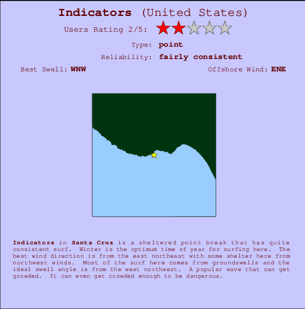
Indicators Surf Guide
Indicators in Santa Cruz is a sheltered point break that has reasonably consistent surf. Winter is the optimum time of year for surfing here. The best wind direction is from the east northeast with some shelter here from northwest winds. Groundswells more frequent than windswells and the optimum swell angle is from the west northwest. Often Crowded. Overcrowding can even make surfing hazardous.
Indicators Spot Info
| Type: | Rating: | Reliability: | Todays Sea Temp*: |
|---|---|---|---|
| fairly consistent | 16.2°C*ocean temperature recorded from satellite |
Surfing Indicators:
The best conditions reported for surf at Indicators occur when a West-northwest swell combines with an offshore wind direction from the East-northeast.

Energía de Olas (poder): 12 horas


Indicators Surf:
Wednesday, 15 July 2026, 06:44 Local time| miércoles 15 | ||||
| 2AM | 5AM | 8AM | 11AM | |
| Wave (m) | ||||
| Período (s) | 7 | 7 | 7 | 8 |
| Viento (km/h) | ||||
| Estado del Viento | glass | glass | glass | on |
- /breaks/Indicators/forecasts/latest
Indicators Surf Guide
Indicators in Santa Cruz is a sheltered point break that has reasonably consistent surf. Winter is the optimum time of year for surfing here. The best wind direction is from the east northeast with some shelter here from northwest winds. Groundswells more frequent than windswells and the optimum swell angle is from the west northwest. Often Crowded. Overcrowding can even make surfing hazardous.
Indicators Spot Info
Type: Rating: Reliability: Todays Sea Temp*:  Point
Point 2
2fairly consistent 16.2°C*ocean temperature recorded from satelliteSurfing Indicators:
The best conditions reported for surf at Indicators occur when a West-northwest swell combines with an offshore wind direction from the East-northeast.
Energía de Olas (poder): 12 horas
Usa la barra de navegación de arriba para ver la temperatura del mar en Indicators, fotografías Indicators, previsiones detalladas de olas para Indicators, vientos y previsión del tiempo, webcams para Indicators, viento actual desde estaciones meteorológicas en CAL - Santa Cruz y predicciones de marea para Indicators. Las mapas de olas para United States enseñarán un mapa grande de United States y los mares que rodean. Los mapas de olas pueden ser animadas para mostrar diferentes componentes de olas, la altura de ola, la energía de ola, el período, junto con previsiones de viento y del tiempo. Previsiones actuales del tiempo y del estado del mar provienen de boyas marinas de United States, del barcos que transitan en la zona y de estaciones meteorológicas costeras. Cada página de previsiones tiene un Busca-Olas Regional y Global para localizar las mejores condiciones para surfear en el área de Indicators.
Indicators Surf:
Wednesday, 15 July 2026, 06:44 Local timemiércoles 15 2AM 5AM 8AM 11AM Wave (m) Período (s) 7 7 7 8 Viento (km/h) Estado del Viento glass glass glass on - /breaks/Indicators/forecasts/latest
- /breaks/Indicators/forecasts/latest/six_day
Indicators Surf Guide
Indicators in Santa Cruz is a sheltered point break that has reasonably consistent surf. Winter is the optimum time of year for surfing here. The best wind direction is from the east northeast with some shelter here from northwest winds. Groundswells more frequent than windswells and the optimum swell angle is from the west northwest. Often Crowded. Overcrowding can even make surfing hazardous.
Indicators Spot Info
Type: Rating: Reliability: Todays Sea Temp*: Point2fairly consistent 16.2°C*ocean temperature recorded from satelliteSurfing Indicators:
The best conditions reported for surf at Indicators occur when a West-northwest swell combines with an offshore wind direction from the East-northeast.
Energía de Olas (poder): 12 horas
Usa la barra de navegación de arriba para ver la temperatura del mar en Indicators, fotografías Indicators, previsiones detalladas de olas para Indicators, vientos y previsión del tiempo, webcams para Indicators, viento actual desde estaciones meteorológicas en CAL - Santa Cruz y predicciones de marea para Indicators. Las mapas de olas para United States enseñarán un mapa grande de United States y los mares que rodean. Los mapas de olas pueden ser animadas para mostrar diferentes componentes de olas, la altura de ola, la energía de ola, el período, junto con previsiones de viento y del tiempo. Previsiones actuales del tiempo y del estado del mar provienen de boyas marinas de United States, del barcos que transitan en la zona y de estaciones meteorológicas costeras. Cada página de previsiones tiene un Busca-Olas Regional y Global para localizar las mejores condiciones para surfear en el área de Indicators.
Indicators Surf:
Wednesday, 15 July 2026, 06:44 Local timemiércoles 15 2AM 5AM 8AM 11AM Wave (m) Período (s) 7 7 7 8 Viento (km/h) Estado del Viento glass glass glass on - /breaks/Indicators/forecasts/latest
Indicators Surf Guide
Indicators in Santa Cruz is a sheltered point break that has reasonably consistent surf. Winter is the optimum time of year for surfing here. The best wind direction is from the east northeast with some shelter here from northwest winds. Groundswells more frequent than windswells and the optimum swell angle is from the west northwest. Often Crowded. Overcrowding can even make surfing hazardous.
Indicators Spot Info
Type: Rating: Reliability: Todays Sea Temp*: Point2fairly consistent 16.2°C*ocean temperature recorded from satelliteSurfing Indicators:
The best conditions reported for surf at Indicators occur when a West-northwest swell combines with an offshore wind direction from the East-northeast.
Energía de Olas (poder): 12 horas
Usa la barra de navegación de arriba para ver la temperatura del mar en Indicators, fotografías Indicators, previsiones detalladas de olas para Indicators, vientos y previsión del tiempo, webcams para Indicators, viento actual desde estaciones meteorológicas en CAL - Santa Cruz y predicciones de marea para Indicators. Las mapas de olas para United States enseñarán un mapa grande de United States y los mares que rodean. Los mapas de olas pueden ser animadas para mostrar diferentes componentes de olas, la altura de ola, la energía de ola, el período, junto con previsiones de viento y del tiempo. Previsiones actuales del tiempo y del estado del mar provienen de boyas marinas de United States, del barcos que transitan en la zona y de estaciones meteorológicas costeras. Cada página de previsiones tiene un Busca-Olas Regional y Global para localizar las mejores condiciones para surfear en el área de Indicators.
Indicators Surf:
Wednesday, 15 July 2026, 06:44 Local timemiércoles 15 2AM 5AM 8AM 11AM Wave (m) Período (s) 7 7 7 8 Viento (km/h) Estado del Viento glass glass glass on Tide Times:
Para Santa Cruz, California, a %{dist} %{km} de %{location}.
PROXIMA ES A LAS (hora local) quedan marea alta marea baja Indicators Tide Times and Tide Chart
Live Weather:
At Santa Cruz, 2 km from Indicators.
calm
(km/h)
dryAir temperature
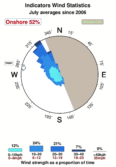
13°COverall Indicators Surf Consistency and Wind Distribution in julio
Fotos de Surf
de la galeríaContornos: Carreteras y Ríos: Selecciona un spot desde el menú 


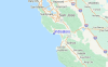
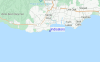
Usa este mapa para navegar hacia las playas de surf de CAL - Santa Cruz y estaciones de marea cercanas de Indicators
Spots de Surf más cercanos a Indicators:
(Clica la ubicación para más detalles)- Closest spot0 mi
- Second closest spot0 mi
- Third closest spot0 mi
- Fourth closest spot1 mi
- Fifth closest spot1 mi
Boyas marinas más cercanas a Indicators:
- Closest Boya Marinas23 mi
- Second closest Boya Marinas24 mi
- Third closest Boya Marinas24 mi
- Fourth closest Boya Marinas42 mi
- Fifth closest Boya Marinas55 mi
Estaciones de marea más cercanas a Indicators:
- Closest estación de mareaSanta Cruz1 mi
- Second closest estación de mareaLive Oak3 mi
- Third closest estación de mareaRio Del Mar7 mi
- Fourth closest estación de mareaAptos7 mi
- Fifth closest estación de mareaElkhorn Slough railroad bridge16 mi
Airports
- The closest passenger airport to Indicators is Norman Y Mineta San Jose International Airport (SJC) in USA, 46 km (29 miles) away (directly).
- The second nearest airport to Indicators is Moffett Federal Afld (Mountain View) Airport (NUQ), also in USA, 52 km (32 miles) away.
- Third is San Francisco International Airport (SFO) in USA, 80 km (50 miles) away.
- Metropolitan Oakland International Airport (OAK) in USA is 87 km (54 miles) away.
- Modesto City Co Harry Sham Airport (MOD), also in USA is the fifth nearest airport to Indicators and is 121 km (75 miles) away.
- /breaks/Indicators/forecasts/latest


 Nearest