

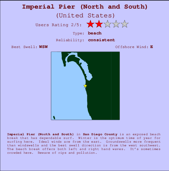
Imperial Pier (North and South) Surf Guide
Imperial Pier (North and South) in San Diego County is an exposed beach break that has consistent surf. Winter is the best time of year for surfing here. Offshore winds blow from the east. Tends to receive distant groundswells and the best swell direction is from the west southwest. The beach breaks offer lefts and rights. Sometimes crowded. Beware of rips and pollution.
Imperial Pier (North and South) Spot Info
| Type: | Rating: | Reliability: | Todays Sea Temp*: |
|---|---|---|---|
| consistent | 21.5°C*ocean temperature recorded from satellite |
Surfing Imperial Pier (North and South):
The best conditions reported for surf at Imperial Pier (North and South) occur when a West-southwest swell combines with an offshore wind direction from the East.

Energía de Olas (poder): 12 horas


Imperial Pier (North and South) Surf:
Saturday, 18 July 2026, 11:52 Local time| sábado 18 | ||||
| 8AM | 11AM | 2PM | 5PM | |
| Wave (m) | ||||
| Período (s) | 17 | 18 | 18 | 18 |
| Viento (km/h) | ||||
| Estado del Viento | cross- on |
on | cross- on |
on |
- /breaks/Imperial-Pier/forecasts/latest
Imperial Pier (North and South) Surf Guide
Imperial Pier (North and South) in San Diego County is an exposed beach break that has consistent surf. Winter is the best time of year for surfing here. Offshore winds blow from the east. Tends to receive distant groundswells and the best swell direction is from the west southwest. The beach breaks offer lefts and rights. Sometimes crowded. Beware of rips and pollution.
Imperial Pier (North and South) Spot Info
Type: Rating: Reliability: Todays Sea Temp*:  Beach
Beach 2
2consistent 21.5°C*ocean temperature recorded from satelliteSurfing Imperial Pier (North and South):
The best conditions reported for surf at Imperial Pier (North and South) occur when a West-southwest swell combines with an offshore wind direction from the East.
Energía de Olas (poder): 12 horas
Usa la barra de navegación de arriba para ver la temperatura del mar en Imperial Pier (North and South), fotografías Imperial Pier (North and South), previsiones detalladas de olas para Imperial Pier (North and South), vientos y previsión del tiempo, webcams para Imperial Pier (North and South), viento actual desde estaciones meteorológicas en CAL - San Diego County y predicciones de marea para Imperial Pier (North and South). Las mapas de olas para United States enseñarán un mapa grande de United States y los mares que rodean. Los mapas de olas pueden ser animadas para mostrar diferentes componentes de olas, la altura de ola, la energía de ola, el período, junto con previsiones de viento y del tiempo. Previsiones actuales del tiempo y del estado del mar provienen de boyas marinas de United States, del barcos que transitan en la zona y de estaciones meteorológicas costeras. Cada página de previsiones tiene un Busca-Olas Regional y Global para localizar las mejores condiciones para surfear en el área de Imperial Pier (North and South).
Imperial Pier (North and South) Surf:
Saturday, 18 July 2026, 11:52 Local timesábado 18 8AM 11AM 2PM 5PM Wave (m) Período (s) 17 18 18 18 Viento (km/h) Estado del Viento cross-
onon cross-
onon - /breaks/Imperial-Pier/forecasts/latest
- /breaks/Imperial-Pier/forecasts/latest/six_day
Imperial Pier (North and South) Surf Guide
Imperial Pier (North and South) in San Diego County is an exposed beach break that has consistent surf. Winter is the best time of year for surfing here. Offshore winds blow from the east. Tends to receive distant groundswells and the best swell direction is from the west southwest. The beach breaks offer lefts and rights. Sometimes crowded. Beware of rips and pollution.
Imperial Pier (North and South) Spot Info
Type: Rating: Reliability: Todays Sea Temp*: Beach2consistent 21.5°C*ocean temperature recorded from satelliteSurfing Imperial Pier (North and South):
The best conditions reported for surf at Imperial Pier (North and South) occur when a West-southwest swell combines with an offshore wind direction from the East.
Energía de Olas (poder): 12 horas
Usa la barra de navegación de arriba para ver la temperatura del mar en Imperial Pier (North and South), fotografías Imperial Pier (North and South), previsiones detalladas de olas para Imperial Pier (North and South), vientos y previsión del tiempo, webcams para Imperial Pier (North and South), viento actual desde estaciones meteorológicas en CAL - San Diego County y predicciones de marea para Imperial Pier (North and South). Las mapas de olas para United States enseñarán un mapa grande de United States y los mares que rodean. Los mapas de olas pueden ser animadas para mostrar diferentes componentes de olas, la altura de ola, la energía de ola, el período, junto con previsiones de viento y del tiempo. Previsiones actuales del tiempo y del estado del mar provienen de boyas marinas de United States, del barcos que transitan en la zona y de estaciones meteorológicas costeras. Cada página de previsiones tiene un Busca-Olas Regional y Global para localizar las mejores condiciones para surfear en el área de Imperial Pier (North and South).
Imperial Pier (North and South) Surf:
Saturday, 18 July 2026, 11:52 Local timesábado 18 8AM 11AM 2PM 5PM Wave (m) Período (s) 17 18 18 18 Viento (km/h) Estado del Viento cross-
onon cross-
onon - /breaks/Imperial-Pier/forecasts/latest
Imperial Pier (North and South) Surf Guide
Imperial Pier (North and South) in San Diego County is an exposed beach break that has consistent surf. Winter is the best time of year for surfing here. Offshore winds blow from the east. Tends to receive distant groundswells and the best swell direction is from the west southwest. The beach breaks offer lefts and rights. Sometimes crowded. Beware of rips and pollution.
Imperial Pier (North and South) Spot Info
Type: Rating: Reliability: Todays Sea Temp*: Beach2consistent 21.5°C*ocean temperature recorded from satelliteSurfing Imperial Pier (North and South):
The best conditions reported for surf at Imperial Pier (North and South) occur when a West-southwest swell combines with an offshore wind direction from the East.
Energía de Olas (poder): 12 horas
Usa la barra de navegación de arriba para ver la temperatura del mar en Imperial Pier (North and South), fotografías Imperial Pier (North and South), previsiones detalladas de olas para Imperial Pier (North and South), vientos y previsión del tiempo, webcams para Imperial Pier (North and South), viento actual desde estaciones meteorológicas en CAL - San Diego County y predicciones de marea para Imperial Pier (North and South). Las mapas de olas para United States enseñarán un mapa grande de United States y los mares que rodean. Los mapas de olas pueden ser animadas para mostrar diferentes componentes de olas, la altura de ola, la energía de ola, el período, junto con previsiones de viento y del tiempo. Previsiones actuales del tiempo y del estado del mar provienen de boyas marinas de United States, del barcos que transitan en la zona y de estaciones meteorológicas costeras. Cada página de previsiones tiene un Busca-Olas Regional y Global para localizar las mejores condiciones para surfear en el área de Imperial Pier (North and South).
Imperial Pier (North and South) Surf:
Saturday, 18 July 2026, 11:52 Local timesábado 18 8AM 11AM 2PM 5PM Wave (m) Período (s) 17 18 18 18 Viento (km/h) Estado del Viento cross-
onon cross-
onon Tide Times:
En Imperial Beach, California (0 km).
PROXIMA ES A LAS (hora local) quedan marea alta marea baja Imperial Pier (North and South) Tide Times and Tide Chart
Live Weather:
At BUOY-TIXC1, 0 km from Imperial Pier (North and South).
light winds from the WNW
(km/h)Air temperature
23.1°COverall Imperial Pier (North and South) Surf Consistency and Wind Distribution in julio


Surf stats for Imperial Pier (North and South): see the swell variation by month.

Wind stats for Imperial Pier (North and South): see the variation in direction and stength by month.
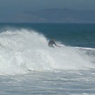
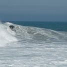
Fotos de Surf
de la galeríaContornos: Carreteras y Ríos: Selecciona un spot desde el menú 


Usa este mapa para navegar hacia las playas de surf de CAL - San Diego County y estaciones de marea cercanas de Imperial Pier (North and South)
Spots de Surf más cercanos a Imperial Pier (North and South):
(Clica la ubicación para más detalles)- Closest spot1 mi
- Second closest spot2 mi
- Third closest spot8 mi
- Fourth closest spot8 mi
- Fifth closest spot9 mi
Boyas marinas más cercanas a Imperial Pier (North and South):
- Closest Boya Marinas2 mi
- Second closest Boya Marinas17 mi
- Third closest Boya Marinas21 mi
- Fourth closest Boya Marinas22 mi
- Fifth closest Boya Marinas24 mi
Estaciones de marea más cercanas a Imperial Pier (North and South):
- Closest estación de mareaImperial Beach0 mi
- Second closest estación de mareaChula Vista4 mi
- Third closest estación de mareaNational City, San Diego Bay6 mi
- Fourth closest estación de mareaTijuana6 mi
- Fifth closest estación de mareaPoint Loma8 mi
Airports
- The closest passenger airport to Imperial Pier (North and South) is North Island Nas (San Diego) Airport (NZY) in USA, 15 km (9 miles) away (directly).
- The second nearest airport to Imperial Pier (North and South) is General Abelardo L Rodriguez International (Tijuana) Airport (TIJ) in Mexico, 16 km (10 miles) away.
- Third is San Diego International Lindbergh Fld Airport (SAN) in USA, 18 km (11 miles) away.
- Miramar Mcas Airport (NKX) in USA is 32 km (20 miles) away.
- General Alberto L Salinas C International (Ensenada) Airport (ESE) in Mexico is the fifth nearest airport to Imperial Pier (North and South) and is 101 km (63 miles) away.
- /breaks/Imperial-Pier/forecasts/latest

 Nearest