
English Channel Left (Fanning Island) Surf Guide
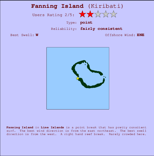
English Channel Left (Fanning Island) in Line Islands is an exposed point break that has quite reliable surf. The best wind direction is from the east northeast. The best swell direction is from the west. Rarely crowded here.
English Channel Left (Fanning Island) Spot Info
| Type: | Rating: | Reliability: | Todays Sea Temp*: |
|---|---|---|---|
| fairly consistent | 31.0°C*ocean temperature recorded from satellite |
Surfing English Channel Left (Fanning Island):
The best conditions reported for surf at English Channel Left (Fanning Island) occur when a West swell combines with an offshore wind direction from the East-northeast.
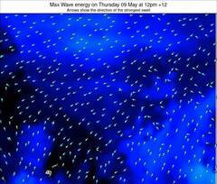
Energía de Olas (poder): 12 horas

English Channel Left (Fanning Island) Surf:
Saturday, 18 July 2026, 09:51 Local time| viernes 17 | ||||
| 11AM | 2PM | 5PM | 8PM | |
| Wave (m) | ||||
| Período (s) | 11 | 15 | 10 | 14 |
| Viento (km/h) | ||||
| Estado del Viento | cross- off |
cross- off |
cross- off |
cross- off |
- /breaks/Fanning-Island/forecasts/latest
English Channel Left (Fanning Island) Surf Guide
English Channel Left (Fanning Island) in Line Islands is an exposed point break that has quite reliable surf. The best wind direction is from the east northeast. The best swell direction is from the west. Rarely crowded here.
English Channel Left (Fanning Island) Spot Info
Type: Rating: Reliability: Todays Sea Temp*:  Point
Point 4
4fairly consistent 31.0°C*ocean temperature recorded from satelliteSurfing English Channel Left (Fanning Island):
The best conditions reported for surf at English Channel Left (Fanning Island) occur when a West swell combines with an offshore wind direction from the East-northeast.
Energía de Olas (poder): 12 horas
Usa la barra de navegación de arriba para ver la temperatura del mar en English Channel Left (Fanning Island), fotografías English Channel Left (Fanning Island), previsiones detalladas de olas para English Channel Left (Fanning Island), vientos y previsión del tiempo, webcams para English Channel Left (Fanning Island), viento actual desde estaciones meteorológicas en Line Islands y predicciones de marea para English Channel Left (Fanning Island). Las mapas de olas para Kiribati enseñarán un mapa grande de Kiribati y los mares que rodean. Los mapas de olas pueden ser animadas para mostrar diferentes componentes de olas, la altura de ola, la energía de ola, el período, junto con previsiones de viento y del tiempo. Previsiones actuales del tiempo y del estado del mar provienen de boyas marinas de Kiribati, del barcos que transitan en la zona y de estaciones meteorológicas costeras. Cada página de previsiones tiene un Busca-Olas Regional y Global para localizar las mejores condiciones para surfear en el área de English Channel Left (Fanning Island).
English Channel Left (Fanning Island) Surf:
Saturday, 18 July 2026, 09:51 Local timeviernes 17 11AM 2PM 5PM 8PM Wave (m) Período (s) 11 15 10 14 Viento (km/h) Estado del Viento cross-
offcross-
offcross-
offcross-
off- /breaks/Fanning-Island/forecasts/latest
- /breaks/Fanning-Island/forecasts/latest/six_day
English Channel Left (Fanning Island) Surf Guide
English Channel Left (Fanning Island) in Line Islands is an exposed point break that has quite reliable surf. The best wind direction is from the east northeast. The best swell direction is from the west. Rarely crowded here.
English Channel Left (Fanning Island) Spot Info
Type: Rating: Reliability: Todays Sea Temp*: Point4fairly consistent 31.0°C*ocean temperature recorded from satelliteSurfing English Channel Left (Fanning Island):
The best conditions reported for surf at English Channel Left (Fanning Island) occur when a West swell combines with an offshore wind direction from the East-northeast.
Energía de Olas (poder): 12 horas
Usa la barra de navegación de arriba para ver la temperatura del mar en English Channel Left (Fanning Island), fotografías English Channel Left (Fanning Island), previsiones detalladas de olas para English Channel Left (Fanning Island), vientos y previsión del tiempo, webcams para English Channel Left (Fanning Island), viento actual desde estaciones meteorológicas en Line Islands y predicciones de marea para English Channel Left (Fanning Island). Las mapas de olas para Kiribati enseñarán un mapa grande de Kiribati y los mares que rodean. Los mapas de olas pueden ser animadas para mostrar diferentes componentes de olas, la altura de ola, la energía de ola, el período, junto con previsiones de viento y del tiempo. Previsiones actuales del tiempo y del estado del mar provienen de boyas marinas de Kiribati, del barcos que transitan en la zona y de estaciones meteorológicas costeras. Cada página de previsiones tiene un Busca-Olas Regional y Global para localizar las mejores condiciones para surfear en el área de English Channel Left (Fanning Island).
English Channel Left (Fanning Island) Surf:
Saturday, 18 July 2026, 09:51 Local timeviernes 17 11AM 2PM 5PM 8PM Wave (m) Período (s) 11 15 10 14 Viento (km/h) Estado del Viento cross-
offcross-
offcross-
offcross-
off- /breaks/Fanning-Island/forecasts/latest
English Channel Left (Fanning Island) Surf Guide
English Channel Left (Fanning Island) in Line Islands is an exposed point break that has quite reliable surf. The best wind direction is from the east northeast. The best swell direction is from the west. Rarely crowded here.
English Channel Left (Fanning Island) Spot Info
Type: Rating: Reliability: Todays Sea Temp*: Point4fairly consistent 31.0°C*ocean temperature recorded from satelliteSurfing English Channel Left (Fanning Island):
The best conditions reported for surf at English Channel Left (Fanning Island) occur when a West swell combines with an offshore wind direction from the East-northeast.
Energía de Olas (poder): 12 horas
Usa la barra de navegación de arriba para ver la temperatura del mar en English Channel Left (Fanning Island), fotografías English Channel Left (Fanning Island), previsiones detalladas de olas para English Channel Left (Fanning Island), vientos y previsión del tiempo, webcams para English Channel Left (Fanning Island), viento actual desde estaciones meteorológicas en Line Islands y predicciones de marea para English Channel Left (Fanning Island). Las mapas de olas para Kiribati enseñarán un mapa grande de Kiribati y los mares que rodean. Los mapas de olas pueden ser animadas para mostrar diferentes componentes de olas, la altura de ola, la energía de ola, el período, junto con previsiones de viento y del tiempo. Previsiones actuales del tiempo y del estado del mar provienen de boyas marinas de Kiribati, del barcos que transitan en la zona y de estaciones meteorológicas costeras. Cada página de previsiones tiene un Busca-Olas Regional y Global para localizar las mejores condiciones para surfear en el área de English Channel Left (Fanning Island).
English Channel Left (Fanning Island) Surf:
Saturday, 18 July 2026, 09:51 Local timeviernes 17 11AM 2PM 5PM 8PM Wave (m) Período (s) 11 15 10 14 Viento (km/h) Estado del Viento cross-
offcross-
offcross-
offcross-
offTide Times:
Para Tabuaeran (Fanning) Island, Line Islands, Kiribati (2), a %{dist} %{km} de %{location}.
PROXIMA ES A LAS (hora local) quedan marea alta marea baja English Channel Left (Fanning Island) Tide Times and Tide Chart
Live Weather:
At Kiritimati Airport (Christmas Island), 296 km from English Channel Left (Fanning Island).
wind obs. (9 kph from 130 degs) was rejected
(km/h)Air temperature
22°COverall English Channel Left (Fanning Island) Surf Consistency and Wind Distribution in julio


Surf stats for English Channel Left (Fanning Island): see the swell variation by month.
Wind stats for English Channel Left (Fanning Island): see the variation in direction and stength by month.
Fotos de Surf
de la galeríaContornos: Carreteras y Ríos: Selecciona un spot desde el menú 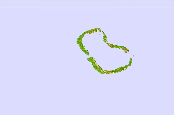

Usa este mapa para navegar hacia las playas de surf de Line Islands y estaciones de marea cercanas de English Channel Left (Fanning Island)
Spots de Surf más cercanos a English Channel Left (Fanning Island):
(Clica la ubicación para más detalles)- Closest spot1073 mi
- Second closest spot1073 mi
- Third closest spot1076 mi
- Fourth closest spot1078 mi
- Fifth closest spot1101 mi
Boyas marinas más cercanas a English Channel Left (Fanning Island):
- Closest Boya Marinas921 mi
- Second closest Boya Marinas1057 mi
- Third closest Boya Marinas1140 mi
- Fourth closest Boya Marinas1179 mi
- Fifth closest Boya Marinas1203 mi
Estaciones de marea más cercanas a English Channel Left (Fanning Island):
- Closest estación de mareaTabuaeran (Fanning) Island, Line Islands (2)1 mi
- Second closest estación de mareaChristmas Island, Gilbert Islands (2)185 mi
- Third closest estación de mareaKiritiamati (Christmas) Island, Line Islands (2)185 mi
- Fourth closest estación de mareaPalmyra Island233 mi
- Fifth closest estación de mareaOcean Island, Gilbert Islands734 mi
Airports
- The nearest passenger airport to Fanning Island is Christmas Island (Kiritimati) Airport (CXI) in Kiribati, which is 307 km (191 miles) away (directly).
- The second closest airport to Fanning Island is Kona International At Keahole Airport (KOA) in Usa Hawaii Isl., 1803 km (1120 miles) away.
- /breaks/Fanning-Island/forecasts/latest
 Nearest