
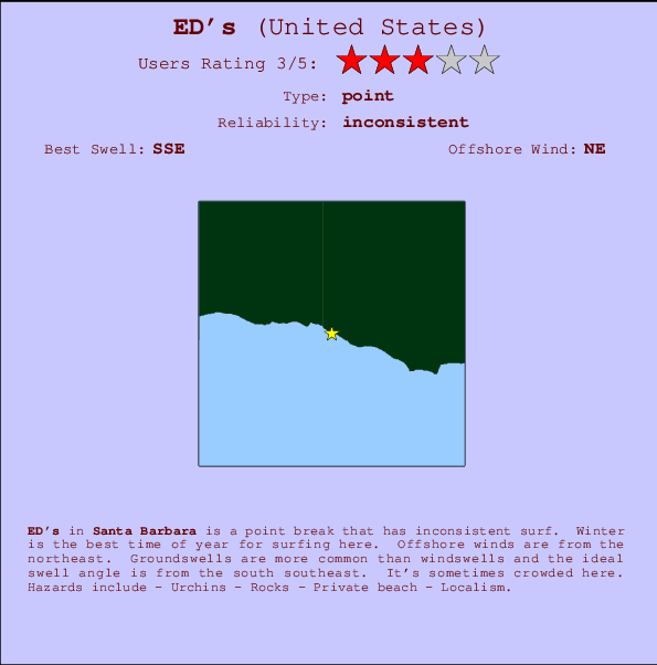
ED's Surf Guide
ED's in Santa Barbara is a fairly exposed point break that does not work very often. Winter is the optimum time of year for surfing here. Offshore winds blow from the northeast. Tends to receive distant groundswells and the ideal swell direction is from the south southeast. When the surf is up, it can get quite busy in the water. Hazards include - Urchins - Rocks - Private beach - Localism.
ED's Spot Info
| Type: | Rating: | Reliability: | Todays Sea Temp*: |
|---|---|---|---|
| inconsistent | 18.0°C*ocean temperature recorded from satellite |
Surfing ED's:
The best conditions reported for surf at ED's occur when a South-southeast swell combines with an offshore wind direction from the Northeast.

Energía de Olas (poder): 12 horas


ED's Surf:
Tuesday, 14 July 2026, 12:33 Local time| martes 14 | ||||
| 8AM | 11AM | 2PM | 5PM | |
| Wave (m) | ||||
| Período (s) | 12 | 13 | 12 | 12 |
| Viento (km/h) | ||||
| Estado del Viento | glass | on | on | cross- on |
- /breaks/ED-s/forecasts/latest
ED's Surf Guide
ED's in Santa Barbara is a fairly exposed point break that does not work very often. Winter is the optimum time of year for surfing here. Offshore winds blow from the northeast. Tends to receive distant groundswells and the ideal swell direction is from the south southeast. When the surf is up, it can get quite busy in the water. Hazards include - Urchins - Rocks - Private beach - Localism.
ED's Spot Info
Type: Rating: Reliability: Todays Sea Temp*:  Point
Point 3
3inconsistent 18.0°C*ocean temperature recorded from satelliteSurfing ED's:
The best conditions reported for surf at ED's occur when a South-southeast swell combines with an offshore wind direction from the Northeast.
Energía de Olas (poder): 12 horas
Usa la barra de navegación de arriba para ver la temperatura del mar en ED's, fotografías ED's, previsiones detalladas de olas para ED's, vientos y previsión del tiempo, webcams para ED's, viento actual desde estaciones meteorológicas en CAL - Santa Barbara y predicciones de marea para ED's. Las mapas de olas para United States enseñarán un mapa grande de United States y los mares que rodean. Los mapas de olas pueden ser animadas para mostrar diferentes componentes de olas, la altura de ola, la energía de ola, el período, junto con previsiones de viento y del tiempo. Previsiones actuales del tiempo y del estado del mar provienen de boyas marinas de United States, del barcos que transitan en la zona y de estaciones meteorológicas costeras. Cada página de previsiones tiene un Busca-Olas Regional y Global para localizar las mejores condiciones para surfear en el área de ED's.
ED's Surf:
Tuesday, 14 July 2026, 12:33 Local timemartes 14 8AM 11AM 2PM 5PM Wave (m) Período (s) 12 13 12 12 Viento (km/h) Estado del Viento glass on on cross-
on- /breaks/ED-s/forecasts/latest
- /breaks/ED-s/forecasts/latest/six_day
ED's Surf Guide
ED's in Santa Barbara is a fairly exposed point break that does not work very often. Winter is the optimum time of year for surfing here. Offshore winds blow from the northeast. Tends to receive distant groundswells and the ideal swell direction is from the south southeast. When the surf is up, it can get quite busy in the water. Hazards include - Urchins - Rocks - Private beach - Localism.
ED's Spot Info
Type: Rating: Reliability: Todays Sea Temp*: Point3inconsistent 18.0°C*ocean temperature recorded from satelliteSurfing ED's:
The best conditions reported for surf at ED's occur when a South-southeast swell combines with an offshore wind direction from the Northeast.
Energía de Olas (poder): 12 horas
Usa la barra de navegación de arriba para ver la temperatura del mar en ED's, fotografías ED's, previsiones detalladas de olas para ED's, vientos y previsión del tiempo, webcams para ED's, viento actual desde estaciones meteorológicas en CAL - Santa Barbara y predicciones de marea para ED's. Las mapas de olas para United States enseñarán un mapa grande de United States y los mares que rodean. Los mapas de olas pueden ser animadas para mostrar diferentes componentes de olas, la altura de ola, la energía de ola, el período, junto con previsiones de viento y del tiempo. Previsiones actuales del tiempo y del estado del mar provienen de boyas marinas de United States, del barcos que transitan en la zona y de estaciones meteorológicas costeras. Cada página de previsiones tiene un Busca-Olas Regional y Global para localizar las mejores condiciones para surfear en el área de ED's.
ED's Surf:
Tuesday, 14 July 2026, 12:33 Local timemartes 14 8AM 11AM 2PM 5PM Wave (m) Período (s) 12 13 12 12 Viento (km/h) Estado del Viento glass on on cross-
on- /breaks/ED-s/forecasts/latest
ED's Surf Guide
ED's in Santa Barbara is a fairly exposed point break that does not work very often. Winter is the optimum time of year for surfing here. Offshore winds blow from the northeast. Tends to receive distant groundswells and the ideal swell direction is from the south southeast. When the surf is up, it can get quite busy in the water. Hazards include - Urchins - Rocks - Private beach - Localism.
ED's Spot Info
Type: Rating: Reliability: Todays Sea Temp*: Point3inconsistent 18.0°C*ocean temperature recorded from satelliteSurfing ED's:
The best conditions reported for surf at ED's occur when a South-southeast swell combines with an offshore wind direction from the Northeast.
Energía de Olas (poder): 12 horas
Usa la barra de navegación de arriba para ver la temperatura del mar en ED's, fotografías ED's, previsiones detalladas de olas para ED's, vientos y previsión del tiempo, webcams para ED's, viento actual desde estaciones meteorológicas en CAL - Santa Barbara y predicciones de marea para ED's. Las mapas de olas para United States enseñarán un mapa grande de United States y los mares que rodean. Los mapas de olas pueden ser animadas para mostrar diferentes componentes de olas, la altura de ola, la energía de ola, el período, junto con previsiones de viento y del tiempo. Previsiones actuales del tiempo y del estado del mar provienen de boyas marinas de United States, del barcos que transitan en la zona y de estaciones meteorológicas costeras. Cada página de previsiones tiene un Busca-Olas Regional y Global para localizar las mejores condiciones para surfear en el área de ED's.
ED's Surf:
Tuesday, 14 July 2026, 12:33 Local timemartes 14 8AM 11AM 2PM 5PM Wave (m) Período (s) 12 13 12 12 Viento (km/h) Estado del Viento glass on on cross-
onTide Times:
Para Beavers, a %{dist} %{km} de %{location}.
PROXIMA ES A LAS (hora local) quedan marea alta marea baja ED's Tide Times and Tide Chart
Live Weather:
At Santa Barbara Airport, 13 km from ED's.
wind obs. (11 kph from 160 degs) was rejected
(km/h)
ClearAir temperature
20.0°CBuoy Data:
At East Santa Barbara Buoy, 16 miles from ED's.
6AM 7AM 8AM 9AM Antigüedad de datos 5 hr 4 hr 3 hr 2 hr Altura de Olas (m) 

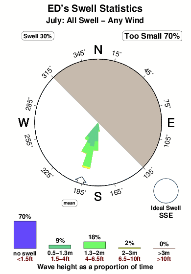
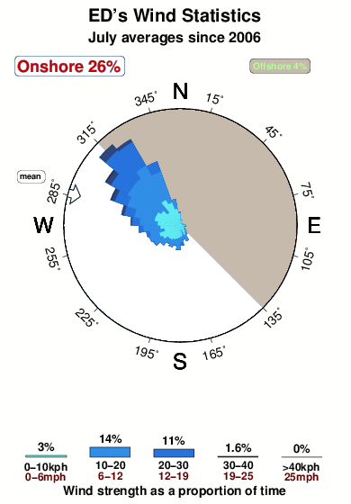
Overall ED's Surf Consistency and Wind Distribution in julio
Fotos de Surf
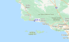
de la galeríaContornos: Carreteras y Ríos: Selecciona un spot desde el menú 


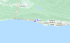
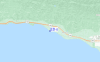
Usa este mapa para navegar hacia las playas de surf de CAL - Santa Barbara y estaciones de marea cercanas de ED's
Spots de Surf más cercanos a ED's:
(Clica la ubicación para más detalles)- Closest spot2 mi
- Second closest spot2 mi
- Third closest spot4 mi
- Fourth closest spot4 mi
- Fifth closest spot5 mi
Boyas marinas más cercanas a ED's:
- Closest Boya Marinas16 mi
- Second closest Boya Marinas30 mi
- Third closest Boya Marinas37 mi
- Fourth closest Boya Marinas45 mi
- Fifth closest Boya Marinas54 mi
Estaciones de marea más cercanas a ED's:
- Closest estación de mareaIsla Vista7 mi
- Second closest estación de mareaGoleta9 mi
- Third closest estación de mareaGaviota13 mi
- Fourth closest estación de mareaSanta Barbara17 mi
- Fifth closest estación de mareaMontecito21 mi
Airports
- The closest passenger airport to ED's is Vandenberg Afb (Lompoc) Airport (VBG) in USA, 62 km (39 miles) away (directly).
- The second nearest airport to ED's is Point Mugu Nas Airport (NTD), also in USA, 88 km (55 miles) away.
- Third is Meadows Fld (Bakersfield) Airport (BFL) in USA, 139 km (86 miles) away.
- Burbank Glendale Pasadena Airport (BUR) in USA is 152 km (94 miles) away.
- Los Angeles International Airport (LAX), also in USA is the fifth nearest airport to ED's and is 156 km (97 miles) away.
- /breaks/ED-s/forecasts/latest


 Nearest