
Previsiones:

Pronóstico Corto PlazoLluvia ligera (totál 9mm), cayendo mayormente el sábado por la noche. Warm (max 23°C el domingo por la tarde, min 13°C el domingo por la noche). Vientos decreciente (vientos frescos desde el SSO el sábado por la noche, Vientos ligeros desde el SO por la noche de lunes). | ||||||||||||||||||||
sáb 18 | domingo 19 | lunes 20 | ||||||||||||||||||
12 PM | 3 PM | 6 PM | 9 PM | 12 AM | 3 AM | 6 AM | 9 AM | 12 PM | 3 PM | 6 PM | 9 PM | 12 AM | 3 AM | 6 AM | 9 AM | 12 PM | 3 PM | 6 PM | 9 PM | |
Mapa de Altura de Olas | 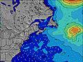 | 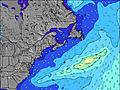 | 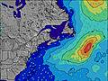 | 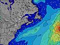 | 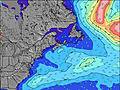 | 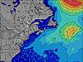 | 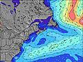 | 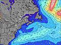 | ||||||||||||
Oleaje Altura (m) Dirección Período (s) | SE 13 | SE 13 | S 5 | S 5 | S 5 | S 6 | SE 13 | SE 12 | SE 12 | SE 12 | SE 8 | SE 8 | E 9 | E 9 | SE 7 | SE 7 | SE 6 | SW 4 | E 7 | E 7 |
Gráfico Olas | ||||||||||||||||||||
28 | 27 | 54 | 53 | 57 | 191 | 26 | 25 | 24 | 23 | 69 | 57 | 2 | 2 | 23 | 15 | 14 | 22 | 1 | 5 | |
Viento (km/h) | ||||||||||||||||||||
Estado del Viento Viento de Mar Viento de Mar-Cruzado Cruzado Viento de Tierra-Cruzado Viento de Tierra Cristalino | cross | cross-on | cross | cross-on | cross-on | cross-on | cross-on | cross | cross-off | cross-off | off | cross-off | cross-off | cross-off | cross-off | cross-off | cross-off | cross-off | cross-off | cross-off |
Marea alta | 12:20PM1.70m | 00:32AM1.64m | 1:08PM1.65m | 1:23AM1.52m | 1:56PM1.60m | |||||||||||||||
Marea baja | 6:27PM0.28m | 6:48AM0.18m | 7:20PM0.33m | 7:34AM0.29m | 8:14PM0.39m | |||||||||||||||
— | — | — | — | — | 5:50 | — | — | — | — | — | — | — | 5:52 | — | — | — | — | — | — | |
— | — | 8:55 | — | — | — | — | — | — | — | 8:55 | — | — | — | — | — | — | — | 8:54 | — | |
mm | — | — | — | — | — | 5 | 3 | 1 | — | — | — | — | — | — | — | — | — | — | — | — |
Temp. °C | 23 | 22 | 20 | 17 | 17 | 17 | 18 | 18 | 18 | 23 | 23 | 20 | 16 | 15 | 13 | 17 | 21 | 23 | 23 | 21 |
Enfriamiento °C | 19 | 17 | 16 | 14 | 12 | 13 | 14 | 15 | 17 | 20 | 19 | 18 | 13 | 12 | 10 | 14 | 17 | 17 | 19 | 18 |
Oleaje 1 Altura (m) Dirección Período (s) | SE 13 | SE 13 | SE 13 | SE 13 | SE 13 | SE 13 | SE 13 | SE 12 | SE 12 | S 7 | S 7 | S 7 | S 7 | S 8 | S 8 | S 8 | S 8 | SSW 8 | S 8 | S 8 |
28 | 27 | 27 | 27 | 27 | 27 | 26 | 25 | 24 | 269 | 181 | 147 | 150 | 164 | 100 | 103 | 113 | 118 | 104 | 78 | |
Oleaje 2 Altura (m) Dirección Período (s) | E 8 | E 8 | E 8 | E 10 | E 9 | E 11 | E 9 | E 9 | E 10 | SE 12 | SE 8 | SE 8 | SSE 12 | SSE 12 | SE 7 | SE 7 | SE 6 | SE 7 | SSE 12 | SE 12 |
1 | 1 | 1 | 2 | 2 | 2 | 2 | 2 | 2 | 23 | 69 | 57 | 14 | 14 | 23 | 15 | 14 | 11 | 14 | 5 | |
Oleaje 3 Altura (m) Dirección Período (s) | E 8 | E 8 | — | — | E 13 | E 9 | — | — | — | — | SSE 12 | SSE 12 | E 9 | E 9 | SSE 12 | SSE 12 | SSE 12 | SSE 12 | E 7 | E 7 |
1 | 1 | — | — | 3 | 2 | — | — | — | — | 14 | 14 | 2 | 2 | 14 | 14 | 14 | 14 | 1 | 4 | |
Olas de Viento Altura (m) Dirección Período (s) | S 7 | S 4 | S 5 | S 5 | S 5 | S 6 | S 7 | S 7 | S 7 | SSW 7 | — | WNW 3 | NW 3 | W 2 | W 2 | — | SW 3 | SW 4 | WNW 2 | — |
28 | 24 | 54 | 53 | 57 | 191 | 309 | 303 | 270 | 337 | — | 4 | 2 | 1 | 1 | — | 2 | 22 | 1 | — | |
Viento del Tierra o Mar Limpio más proximo | ||||||||||||||||||||
Distancia (km) | 424 | 3462 | 3462 | 948 | 938 | 896 | 500 | 500 | 500 | 566 | 2 | 2 | 2 | 2 | 2 | 424 | 424 | 670 | 2 | 99 |
Mejores Olas Previstas en Nova Scotia | ||||||||||||||||||||
Mejores Olas Previstas en Canada | ||||||||||||||||||||
Busca-Olas Global | ||||||||||||||||||||
- Map Icons:
 Break
Break Live Wave Height (m)
 Live Wind Speed (km/h)
 Surf Rating (10 Max)
 Ocean Swells (m)
- Wind Speed (km/h)
GRÁTIS! Un widget de Surf-Forecast.com para tu sitio
Este widget grátis de previsiones de surf y tiempo puede ser añadido a cualquier otro sitio y da un resumen de previsiones de olas para Cherry Hill. Solo necesita cortar y pegar el código HTML de abajo en su web. Puede elegir preferencias de idioma y de unidades (métricas o imperiales) para convenir a los usuarios de su sitio. Clica aquí para obtener el código.
 Nearest