
Previsiones:

Pronóstico Corto PlazoMayormente seco. Very mild (max 16°C el martes por la tarde, min 12°C el miércoles por la noche). El viento será generalmente ligero. | ||||||||||||||||||||||||
lunes 27 | martes 28 | miércoles 29 | ||||||||||||||||||||||
2 AM | 5 AM | 8 AM | 11 AM | 2 PM | 5 PM | 8 PM | 11 PM | 2 AM | 5 AM | 8 AM | 11 AM | 2 PM | 5 PM | 8 PM | 11 PM | 2 AM | 5 AM | 8 AM | 11 AM | 2 PM | 5 PM | 8 PM | 11 PM | |
Mapa de Altura de Olas |  |  |  |  |  |  |  | 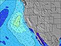 |  | |||||||||||||||
Oleaje Altura (m) Dirección Período (s) | NW 6 | NW 5 | NW 10 | NW 10 | NW 9 | NW 6 | NW 6 | NW 6 | NW 6 | NW 6 | NW 6 | NW 6 | NW 6 | NW 7 | SW 17 | NW 7 | NW 6 | NW 6 | NW 6 | NW 6 | NW 7 | NW 7 | NW 8 | NW 8 |
Gráfico Olas | ||||||||||||||||||||||||
103 | 74 | 77 | 200 | 246 | 123 | 236 | 251 | 236 | 193 | 132 | 187 | 228 | 396 | 885 | 436 | 293 | 236 | 226 | 263 | 453 | 508 | 717 | 736 | |
Viento (km/h) | ||||||||||||||||||||||||
Estado del Viento Viento de Mar Viento de Mar-Cruzado Cruzado Viento de Tierra-Cruzado Viento de Tierra Cristalino | cross | cross | cross | cross-on | cross-on | cross-on | cross-on | cross-on | cross | cross | cross-on | cross-on | cross-on | cross-on | cross-on | cross | cross | cross | cross-on | cross-on | cross-on | cross-on | cross-on | cross-on |
Marea alta | 12:06PM1.30m | 10:18PM1.90m | 12:34PM1.34m | 10:57PM1.92m | 1:00PM1.38m | |||||||||||||||||||
Marea baja | 5:07AM-0.12m | 4:13PM0.97m | 5:40AM-0.15m | 4:54PM0.93m | 6:12AM-0.17m | 5:34PM0.88m | ||||||||||||||||||
— | 6:09 | — | — | — | — | — | — | — | 6:11 | — | — | — | — | — | — | — | 6:11 | — | — | — | — | — | — | |
— | — | — | — | — | — | 8:31 | — | — | — | — | — | — | — | 8:30 | — | — | — | — | — | — | — | 8:30 | — | |
mm | — | — | — | — | — | — | — | — | — | — | — | — | — | — | — | — | — | — | — | — | — | — | — | — |
Temp. °C | 13 | 12 | 13 | 14 | 15 | 14 | 14 | 13 | 13 | 13 | 13 | 15 | 16 | 16 | 15 | 14 | 13 | 13 | 14 | 15 | 15 | 15 | 14 | 13 |
Enfriamiento °C | 13 | 11 | 12 | 12 | 12 | 11 | 11 | 11 | 11 | 11 | 11 | 12 | 12 | 12 | 11 | 12 | 11 | 11 | 12 | 11 | 11 | 11 | 12 | 11 |
Oleaje 1 Altura (m) Dirección Período (s) | SW 18 | SW 18 | SSW 18 | SSW 18 | SSW 18 | SSW 19 | SSW 19 | SSW 19 | SW 19 | SSW 17 | SSW 17 | SSW 17 | SSW 18 | SSW 18 | SW 17 | SSW 17 | SSW 17 | SSW 17 | SSW 16 | SSW 16 | SSW 16 | SSW 16 | SSW 16 | SSW 16 |
719 | 719 | 835 | 845 | 1068 | 1153 | 1203 | 1123 | 837 | 735 | 780 | 932 | 943 | 1081 | 885 | 798 | 780 | 848 | 751 | 539 | 539 | 627 | 627 | 441 | |
Oleaje 2 Altura (m) Dirección Período (s) | SSW 21 | SSW 21 | NW 10 | SSW 11 | SSW 11 | SSW 11 | SSW 11 | SSW 10 | SSW 16 | SSW 10 | NW 9 | SSW 12 | SSW 12 | SSW 11 | S 19 | S 19 | S 20 | S 20 | S 18 | S 18 | S 18 | S 18 | S 18 | S 17 |
260 | 253 | 77 | 25 | 40 | 40 | 41 | 20 | 144 | 21 | 52 | 56 | 55 | 51 | 259 | 267 | 119 | 119 | 98 | 227 | 227 | 221 | 221 | 386 | |
Oleaje 3 Altura (m) Dirección Período (s) | S 13 | SSW 13 | SSW 13 | SW 14 | SSW 13 | — | — | SW 12 | SSW 10 | SW 12 | SSW 12 | SSW 9 | S 12 | SSW 11 | SSW 11 | SSW 12 | SW 12 | SW 11 | SW 11 | SSW 11 | SSW 11 | SSW 11 | SSW 11 | SSE 16 |
84 | 98 | 98 | 46 | 18 | — | — | 37 | 36 | 37 | 56 | 8 | 3 | 51 | 50 | 53 | 34 | 33 | 32 | 12 | 11 | 11 | 11 | 24 | |
Olas de Viento Altura (m) Dirección Período (s) | NW 6 | NW 5 | NW 5 | NW 10 | NW 9 | NW 6 | NW 6 | NW 6 | NW 6 | NW 6 | NW 6 | NW 6 | NW 6 | NW 7 | NW 7 | NW 7 | NW 6 | NW 6 | NW 6 | NW 6 | NW 7 | NW 7 | NW 8 | NW 8 |
103 | 74 | 53 | 200 | 246 | 123 | 236 | 251 | 236 | 193 | 132 | 187 | 228 | 396 | 524 | 436 | 293 | 236 | 226 | 263 | 453 | 508 | 717 | 736 | |
Viento del Tierra o Mar Limpio más proximo | ||||||||||||||||||||||||
Distancia (km) | 6 | 6 | 6 | 209 | 311 | 270 | 23 | 7 | 7 | 7 | 7 | 209 | 311 | 311 | 266 | 7 | 7 | 7 | 7 | 190 | 311 | 310 | 23 | 7 |
Mejores Olas Previstas en Mendocino County | ||||||||||||||||||||||||
Mejores Olas Previstas en United States | ||||||||||||||||||||||||
Busca-Olas Global | ||||||||||||||||||||||||
- Map Icons:
 Break
Break Live Wave Height (m)
 Live Wind Speed (km/h)
 Surf Rating (10 Max)
 Ocean Swells (m)
- Wind Speed (km/h)
GRÁTIS! Un widget de Surf-Forecast.com para tu sitio
Este widget grátis de previsiones de surf y tiempo puede ser añadido a cualquier otro sitio y da un resumen de previsiones de olas para Caspar Creek. Solo necesita cortar y pegar el código HTML de abajo en su web. Puede elegir preferencias de idioma y de unidades (métricas o imperiales) para convenir a los usuarios de su sitio. Clica aquí para obtener el código.
 Nearest