

- Forecast
- Maps
- Live
- Weather State
- Spot Information

Surf Forecasts
Point

Manapany surf Forecast / Réunion / Reunion
48hr Weather and Surf, issued 3 am Sunday 19 May 2024 +04
Forecast update in hr min s Update imminent
Manapany surf forecast is for near shore open water. Breaking waves will often be smaller at less exposed spots.
Today's Manapany sea temperature is 26.1°C (Statistics for 19 May 1981-2005 - mean: 25.5 °C max: 26.7 °C min: 24.8 °C)
- Map Icons:
 Break
Break Live Wave Height (m)
 Live Wind Speed (km/h)
 Surf Rating (10 Max)
 Ocean Swells (m)
- Wind Speed (km/h)
Manapany surf forecast is for near shore open water. Breaking waves will often be smaller at less exposed spots.
Today's Manapany sea temperature is 26.1°C (Statistics for 19 May 1981-2005 - mean: 25.5 °C max: 26.7 °C min: 24.8 °C)
How big are the waves at Manapany today?
The current surf forecast for Manapany at 5AM is: 1.2m 8s primary swell from a East direction (forecast issued at 03:00am May 19). An open ocean swell of 1.9m 16s is not directed at the surf break. The wind direction is predicted to be cross-offshore and the swell rating is 2.
| Time (+04) & Date | Wave Height | Wave Period |
|---|---|---|
| Morning (19 May) | 4ft (1.2m) | 8s |
| Afternoon (19 May) | 3.5ft (1.1m) | 8s |
| Evening (19 May) | 3.5ft (1.0m) | 8s |
Table - waves today at Manapany. (Swell directed towards the surf break)
Updates in hr min s Update imminent
Sunday 19 | Monday 20 | Tuesday 21 | Wednesday 22 | Thursday 23 | Friday 24 | Saturday 25 | Sunday 26 | |||||||||||||||||||||||||||||||||||||||||||||||||||||
| 1 AM | 4 AM | 7 AM | 10 AM | 1 PM | 4 PM | 7 PM | 10 PM | 1 AM | 4 AM | 7 AM | 10 AM | 1 PM | 4 PM | 7 PM | 10 PM | 1 AM | 4 AM | 7 AM | 10 AM | 1 PM | 4 PM | 7 PM | 10 PM | 1 AM | 4 AM | 7 AM | 10 AM | 1 PM | 4 PM | 7 PM | 10 PM | 1 AM | 4 AM | 7 AM | 10 AM | 1 PM | 4 PM | 7 PM | 10 PM | 1 AM | 4 AM | 7 AM | 10 AM | 1 PM | 4 PM | 7 PM | 10 PM | 1 AM | 4 AM | 7 AM | 10 AM | 1 PM | 4 PM | 7 PM | 10 PM | 1 AM | 4 AM | 7 AM | 10 AM | |
Rating (10 max) | ||||||||||||||||||||||||||||||||||||||||||||||||||||||||||||
Swell Height Map |  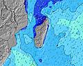 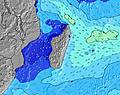 | 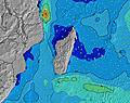 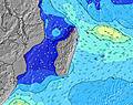 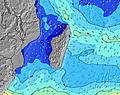 | 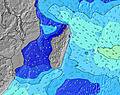 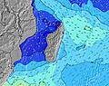 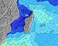 | 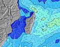 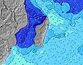 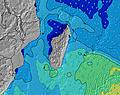 | 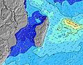 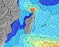 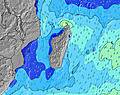 | 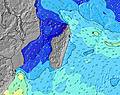 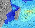 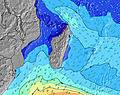 | 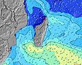 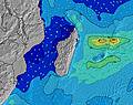 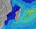 | 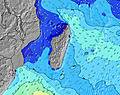 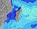 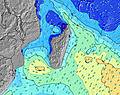 | ||||||||||||||||||||||||||||||||||||||||||||||||||||
| Wave Height (m) & direction (?) | ||||||||||||||||||||||||||||||||||||||||||||||||||||||||||||
| Period(s) (?) | 8 | 8 | 8 | 8 | 8 | 8 | 8 | 8 | 8 | 8 | 8 | 8 | 8 | 8 | 8 | 8 | 10 | 10 | 10 | 10 | 10 | 10 | 10 | 10 | 10 | 9 | 10 | 10 | 10 | 10 | 10 | 10 | 10 | 10 | 10 | 10 | 10 | 9 | 9 | 9 | 9 | 9 | 9 | 9 | 9 | 9 | 9 | 9 | 9 | 9 | 9 | 9 | 9 | 9 | 9 | 9 | 8 | 8 | 9 | 9 |
Wave (?)Graph | ||||||||||||||||||||||||||||||||||||||||||||||||||||||||||||
| Energy (?) | 228 | 195 | 190 | 160 | 156 | 156 | 125 | 125 | 122 | 102 | 104 | 104 | 82 | 82 | 82 | 67 | 1290 | 1758 | 2042 | 2487 | 1308 | 2275 | 2354 | 2473 | 2915 | 1635 | 2755 | 2602 | 2614 | 2523 | 2464 | 2337 | 2194 | 2042 | 1980 | 1835 | 1686 | 1513 | 1441 | 1406 | 1344 | 1376 | 1284 | 1255 | 1119 | 939 | 900 | 740 | 710 | 646 | 542 | 463 | 442 | 384 | 384 | 332 | 277 | 235 | 210 | 214 |
Wind (km/h) | ||||||||||||||||||||||||||||||||||||||||||||||||||||||||||||
| Wind State (?) onshore cross-onshore cross-shore cross-offshore offshore glassy | cross- off | cross- off | cross- off | cross | cross- on | cross- on | cross- on | cross- on | cross- on | cross- on | cross | cross- on | cross- on | cross- on | cross- on | cross- on | cross- on | cross- on | cross- on | cross- on | cross- on | cross- on | cross- on | cross- on | cross- on | cross- on | cross- on | cross | cross- on | cross | cross | cross | cross- on | cross- on | cross | cross | cross | cross | cross | cross | cross | cross | cross- on | cross- on | cross | cross | cross | cross | cross | cross | cross | cross | cross | cross | cross | cross- off | cross- off | cross- off | cross- off | cross- off |
High Tide / height (m) | 10:27PM 0.52 | 10:28AM 0.49 | 10:46PM 0.56 | 11:00AM 0.52 | 11:07PM 0.59 | 11:31AM 0.54 | 11:31PM 0.62 | 12:02PM 0.55 | 11:58PM 0.63 | 12:34PM 0.54 | 12:26AM 0.64 | 1:07PM 0.53 | 12:57AM 0.63 | 1:43PM 0.52 | 1:31AM 0.62 | |||||||||||||||||||||||||||||||||||||||||||||
Low Tide / height (m) | 4:35AM 0.22 | 4:30PM 0.18 | 5:03AM 0.16 | 4:58PM 0.16 | 5:31AM 0.12 | 5:26PM 0.15 | 5:59AM 0.08 | 5:53PM 0.14 | 6:29AM 0.05 | 6:22PM 0.14 | 7:00AM 0.04 | 6:51PM 0.15 | 7:33AM 0.04 | 7:22PM 0.17 | 8:10AM 0.06 | |||||||||||||||||||||||||||||||||||||||||||||
Sunday 19 | Monday 20 | Tuesday 21 | Wednesday 22 | Thursday 23 | Friday 24 | Saturday 25 | Sunday 26 | |||||||||||||||||||||||||||||||||||||||||||||||||||||
| Sunrise | - | - | 6:41 | - | - | - | - | - | - | - | 6:43 | - | - | - | - | - | - | - | 6:43 | - | - | - | - | - | - | - | 6:43 | - | - | - | - | - | - | - | 6:43 | - | - | - | - | - | - | - | 6:43 | - | - | - | - | - | - | - | 6:45 | - | - | - | - | - | - | - | 6:45 | - |
| Sunset | - | - | - | - | - | 5:45 | - | - | - | - | - | - | - | 5:45 | - | - | - | - | - | - | - | 5:44 | - | - | - | - | - | - | - | 5:44 | - | - | - | - | - | - | - | 5:44 | - | - | - | - | - | - | - | 5:44 | - | - | - | - | - | - | - | 5:43 | - | - | - | - | - | - |
Rain (mm) | - | - | - | - | - | - | - | - | - | - | - | - | - | - | - | 1 | 2 | 4 | 5 | 5 | 3 | 1 | 1 | 1 | - | - | 2 | 2 | 2 | 1 | 1 | 1 | 1 | - | - | 1 | 1 | 1 | 1 | 1 | 1 | 1 | 1 | 1 | 1 | 1 | 1 | 1 | 1 | 1 | 1 | 1 | 1 | 1 | - | - | - | - | - | - |
| Temp. °C | 23 | 23 | 23 | 24 | 25 | 24 | 24 | 23 | 23 | 22 | 22 | 24 | 25 | 24 | 23 | 22 | 22 | 22 | 22 | 22 | 22 | 22 | 21 | 21 | 21 | 20 | 21 | 22 | 22 | 22 | 21 | 21 | 21 | 21 | 21 | 22 | 23 | 22 | 22 | 22 | 22 | 21 | 22 | 23 | 24 | 24 | 23 | 23 | 23 | 23 | 23 | 24 | 24 | 24 | 24 | 23 | 23 | 23 | 24 | 25 |
| Feels °C (?) | 25 | 25 | 24 | 25 | 26 | 25 | 25 | 24 | 23 | 22 | 22 | 24 | 24 | 23 | 23 | 21 | 20 | 19 | 18 | 18 | 18 | 18 | 17 | 16 | 17 | 16 | 18 | 18 | 18 | 18 | 17 | 18 | 18 | 18 | 18 | 19 | 20 | 20 | 21 | 20 | 21 | 19 | 21 | 21 | 22 | 23 | 21 | 22 | 23 | 23 | 23 | 24 | 23 | 24 | 24 | 23 | 24 | 23 | 24 | 27 |
FREE! Surf-Forecast.com widget for your website
The surf report / weather widget below is available to embed on third party websites free of charge and provides a summary of our Manapany surf forecast. Simply grab the html code snippet that we provide and paste it into your own site. You can choose your preferred language and metric/imperial units for the surf forecast feed to suit users of your site. Click here to get the code.


 Nearest