
Previsiones:

Pronóstico Corto PlazoLluvia ligera (totál 2mm), cayendo mayormente el miércoles por la tarde. Warm (max 24°C el lunes por la mañana, min 21°C el miércoles por la noche). El viento será generalmente ligero. | ||||||||||||||||||||||
lunes 3 | martes 4 | miércoles 5 | ||||||||||||||||||||
7 AM | 10 AM | 1 PM | 4 PM | 7 PM | 10 PM | 1 AM | 4 AM | 7 AM | 10 AM | 1 PM | 4 PM | 7 PM | 10 PM | 1 AM | 4 AM | 7 AM | 10 AM | 1 PM | 4 PM | 7 PM | 10 PM | |
Mapa de Altura de Olas |  | 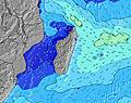 | 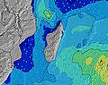 | 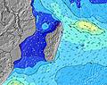 | 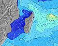 | 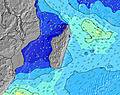 | 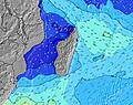 | 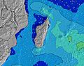 | ||||||||||||||
Oleaje Altura (m) Dirección Período (s) | E 9 | E 9 | E 9 | E 9 | E 9 | E 9 | E 9 | E 9 | E 9 | E 9 | E 9 | E 9 | E 9 | E 9 | E 10 | E 10 | E 10 | E 10 | E 10 | E 10 | E 9 | E 9 |
Gráfico Olas | ||||||||||||||||||||||
1021 | 1104 | 937 | 861 | 788 | 702 | 707 | 718 | 734 | 680 | 665 | 734 | 880 | 899 | 882 | 900 | 832 | 745 | 745 | 858 | 912 | 818 | |
Viento (km/h) | ||||||||||||||||||||||
Estado del Viento Viento de Mar Viento de Mar-Cruzado Cruzado Viento de Tierra-Cruzado Viento de Tierra Cristalino | cross-off | cross-off | cross-off | cross-off | cross-off | cross-off | cross-off | cross-off | cross-off | cross | cross | cross | cross | cross | cross-off | cross-off | cross-off | cross | cross | cross-off | cross | cross |
Marea alta | 3:14PM0.59m | 3:13AM0.57m | 3:48PM0.57m | 3:53AM0.50m | 4:31PM0.53m | |||||||||||||||||
Marea baja | 8:57AM0.09m | 9:13PM0.17m | 9:26AM0.13m | 9:55PM0.20m | 10:01AM0.18m | |||||||||||||||||
6:48 | — | — | — | — | — | — | 6:48 | — | — | — | — | — | — | — | 6:47 | — | — | — | — | — | — | |
— | — | — | 5:59 | — | — | — | — | — | — | — | 5:59 | — | — | — | — | — | — | — | 5:59 | — | — | |
mm | — | — | — | — | — | — | — | — | — | — | — | — | — | — | — | — | — | — | — | 1 | 1 | — |
Temp. °C | 22 | 23 | 24 | 24 | 23 | 23 | 22 | 22 | 22 | 23 | 24 | 23 | 23 | 23 | 22 | 22 | 22 | 24 | 24 | 23 | 22 | 22 |
Enfriamiento °C | 21 | 22 | 23 | 23 | 22 | 22 | 20 | 21 | 21 | 22 | 23 | 22 | 23 | 22 | 21 | 21 | 21 | 23 | 23 | 23 | 21 | 21 |
Oleaje 1 Altura (m) Dirección Período (s) | SW 14 | SW 14 | SW 14 | SW 13 | SW 13 | SW 13 | SW 13 | S 14 | E 9 | SW 13 | S 13 | S 13 | S 13 | S 12 | E 10 | E 10 | E 10 | E 10 | E 10 | SW 15 | SSW 14 | SSW 14 |
706 | 565 | 478 | 451 | 340 | 246 | 246 | 198 | 734 | 161 | 168 | 215 | 153 | 143 | 882 | 900 | 832 | 745 | 745 | 318 | 367 | 352 | |
Oleaje 2 Altura (m) Dirección Período (s) | S 18 | S 18 | S 17 | S 16 | S 16 | S 15 | S 15 | SW 13 | SW 13 | S 13 | SW 12 | SW 12 | SW 12 | SW 12 | S 12 | SSW 15 | SW 15 | SSW 15 | SSW 15 | S 11 | S 11 | S 11 |
627 | 492 | 368 | 330 | 248 | 221 | 209 | 168 | 168 | 171 | 151 | 73 | 92 | 90 | 103 | 154 | 232 | 287 | 387 | 40 | 37 | 37 | |
Oleaje 3 Altura (m) Dirección Período (s) | S 18 | — | S 10 | S 10 | S 10 | S 10 | S 10 | S 10 | S 13 | SSE 10 | SSE 9 | SSE 9 | SW 16 | SSW 16 | SSW 16 | S 12 | S 12 | S 12 | S 12 | S 11 | S 11 | S 11 |
627 | — | 8 | 18 | 19 | 19 | 17 | 17 | 176 | 33 | 17 | 17 | 68 | 104 | 173 | 102 | 100 | 100 | 69 | 2 | 37 | 37 | |
Olas de Viento Altura (m) Dirección Período (s) | E 9 | E 9 | E 9 | E 9 | E 9 | E 9 | E 9 | E 9 | — | E 9 | E 9 | E 9 | E 9 | E 9 | — | — | — | — | — | E 10 | E 9 | E 9 |
1021 | 1104 | 937 | 861 | 788 | 702 | 707 | 718 | — | 680 | 665 | 734 | 880 | 899 | — | — | — | — | — | 858 | 912 | 818 | |
Viento del Tierra o Mar Limpio más proximo | ||||||||||||||||||||||
Distancia (km) | 11 | 11 | 29 | 15 | 15 | 15 | 15 | 11 | 11 | 29 | 29 | 29 | 15 | 15 | 15 | 15 | 15 | 15 | 53 | 15 | 15 | 15 |
Mejores Olas Previstas en Réunion Island | ||||||||||||||||||||||
Mejores Olas Previstas en Reunion | ||||||||||||||||||||||
Busca-Olas Global | ||||||||||||||||||||||
- Map Icons:
 Break
Break Live Wave Height (m)
 Live Wind Speed (km/h)
 Surf Rating (10 Max)
 Ocean Swells (m)
- Wind Speed (km/h)
GRÁTIS! Un widget de Surf-Forecast.com para tu sitio
Este widget grátis de previsiones de surf y tiempo puede ser añadido a cualquier otro sitio y da un resumen de previsiones de olas para Manapany. Solo necesita cortar y pegar el código HTML de abajo en su web. Puede elegir preferencias de idioma y de unidades (métricas o imperiales) para convenir a los usuarios de su sitio. Clica aquí para obtener el código.
 Nearest