
Previsiones:

Pronóstico Corto PlazoMayormente seco. Warm (max 23°C el jueves por la mañana, min 19°C el viernes por la noche). El viento será generalmente ligero. | |||||||||||||||||||||
mié 29 | jueves 30 | viernes 31 | |||||||||||||||||||
10 AM | 1 PM | 4 PM | 7 PM | 10 PM | 1 AM | 4 AM | 7 AM | 10 AM | 1 PM | 4 PM | 7 PM | 10 PM | 1 AM | 4 AM | 7 AM | 10 AM | 1 PM | 4 PM | 7 PM | 10 PM | |
Mapa de Altura de Olas |  | 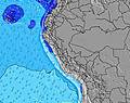 |  | 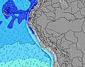 | 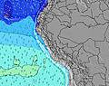 |  | 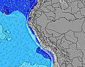 | 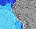 | |||||||||||||
Oleaje Altura (m) Dirección Período (s) | SW 14 | SW 13 | SW 13 | SW 13 | SW 13 | SW 13 | SW 13 | SW 13 | SW 12 | SW 12 | SW 12 | SW 12 | SW 13 | SW 13 | SW 12 | SW 12 | SW 12 | SW 12 | SW 12 | SW 12 | S 7 |
Gráfico Olas | |||||||||||||||||||||
801 | 778 | 755 | 755 | 673 | 663 | 529 | 581 | 496 | 481 | 488 | 496 | 512 | 411 | 392 | 367 | 277 | 272 | 272 | 197 | 197 | |
Viento (km/h) | |||||||||||||||||||||
Estado del Viento Viento de Mar Viento de Mar-Cruzado Cruzado Viento de Tierra-Cruzado Viento de Tierra Cristalino | cross-on | on | cross-on | cross | cross | cross | cross | cross | cross-on | cross-on | cross-on | cross | cross | cross | cross-off | cross | cross | cross-on | cross | cross | cross |
Marea alta | 4:47PM0.70m | 6:03AM1.03m | 5:24PM0.72m | 6:29AM1.04m | 6:01PM0.73m | ||||||||||||||||
Marea baja | 11:54AM0.40m | 11:06PM0.11m | 12:23PM0.38m | 11:37PM0.13m | 12:52PM0.36m | ||||||||||||||||
6:28 | — | — | — | — | — | 6:28 | — | — | — | — | — | — | — | 6:28 | — | — | — | — | — | — | |
— | — | 6:07 | — | — | — | — | — | — | — | 6:08 | — | — | — | — | — | — | — | 6:08 | — | — | |
mm | — | — | — | — | — | — | — | — | — | — | — | — | — | — | — | — | — | — | — | — | — |
Temp. °C | 21 | 22 | 22 | 21 | 21 | 20 | 20 | 20 | 22 | 23 | 23 | 21 | 21 | 20 | 20 | 20 | 21 | 22 | 22 | 21 | 20 |
Enfriamiento °C | 22 | 22 | 22 | 22 | 22 | 20 | 21 | 21 | 23 | 23 | 22 | 20 | 21 | 19 | 20 | 20 | 21 | 20 | 20 | 19 | 18 |
Oleaje 1 Altura (m) Dirección Período (s) | SW 14 | SW 13 | SW 13 | SW 13 | SW 13 | SW 13 | SW 13 | SW 13 | SW 12 | SW 12 | SW 12 | SW 12 | SW 13 | SW 13 | SW 12 | SW 12 | SW 12 | SW 12 | SW 12 | SW 12 | SW 12 |
801 | 778 | 755 | 755 | 673 | 663 | 529 | 581 | 496 | 481 | 488 | 496 | 512 | 411 | 392 | 367 | 277 | 272 | 272 | 197 | 197 | |
Oleaje 2 Altura (m) Dirección Período (s) | S 7 | S 7 | S 7 | S 7 | S 7 | S 12 | S 12 | S 12 | S 12 | S 12 | S 12 | S 11 | S 11 | S 11 | S 11 | S 5 | S 11 | SSW 10 | SSW 10 | S 10 | S 10 |
60 | 60 | 46 | 46 | 44 | 43 | 76 | 43 | 73 | 75 | 70 | 64 | 63 | 61 | 61 | 34 | 58 | 37 | 35 | 32 | 31 | |
Oleaje 3 Altura (m) Dirección Período (s) | S 12 | S 10 | S 10 | WNW 13 | SSW 12 | NW 13 | NW 12 | NW 12 | NW 12 | NW 12 | NW 12 | NW 12 | NW 12 | NW 12 | NW 12 | S 11 | SW 18 | SW 17 | SW 17 | SW 17 | SW 17 |
12 | 18 | 18 | 17 | 52 | 6 | 6 | 6 | 6 | 6 | 6 | 6 | 6 | 6 | 6 | 59 | 13 | 44 | 44 | 44 | 44 | |
Olas de Viento Altura (m) Dirección Período (s) | — | — | — | — | — | S 7 | S 7 | S 7 | S 6 | S 6 | S 6 | S 4 | S 4 | S 5 | S 5 | — | S 5 | S 5 | S 5 | S 6 | S 7 |
— | — | — | — | — | 44 | 43 | 31 | 29 | 38 | 37 | 19 | 26 | 34 | 40 | — | 36 | 59 | 97 | 139 | 168 | |
Viento del Tierra o Mar Limpio más proximo | |||||||||||||||||||||
Distancia (km) | 44 | 263 | 240 | 44 | 44 | 44 | 44 | 44 | 203 | 240 | 263 | 289 | 44 | 192 | 0 | 44 | 44 | 321 | 263 | 289 | 192 |
Mejores Olas Previstas en Ancash | |||||||||||||||||||||
Mejores Olas Previstas en Peru | |||||||||||||||||||||
Busca-Olas Global | |||||||||||||||||||||
- Map Icons:
 Break
Break Live Wave Height (m)
 Live Wind Speed (km/h)
 Surf Rating (10 Max)
 Ocean Swells (m)
- Wind Speed (km/h)
GRÁTIS! Un widget de Surf-Forecast.com para tu sitio
Este widget grátis de previsiones de surf y tiempo puede ser añadido a cualquier otro sitio y da un resumen de previsiones de olas para Centinela. Solo necesita cortar y pegar el código HTML de abajo en su web. Puede elegir preferencias de idioma y de unidades (métricas o imperiales) para convenir a los usuarios de su sitio. Clica aquí para obtener el código.
 Nearest