
Previsiones:

Pronóstico Corto PlazoMayormente seco. Warm (max 21°C el domingo por la mañana, min 20°C el domingo por la mañana). Mayormente vientos frescos. | |||||||||||||||||||||
dom 19 | lunes 20 | martes 21 | |||||||||||||||||||
10 AM | 1 PM | 4 PM | 7 PM | 10 PM | 1 AM | 4 AM | 7 AM | 10 AM | 1 PM | 4 PM | 7 PM | 10 PM | 1 AM | 4 AM | 7 AM | 10 AM | 1 PM | 4 PM | 7 PM | 10 PM | |
Mapa de Altura de Olas |  |  |  | 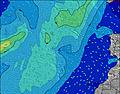 |  |  | 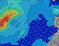 | 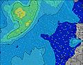 | |||||||||||||
Oleaje Altura (m) Dirección Período (s) | NNE 6 | NNE 7 | NNE 7 | NNE 7 | NNE 6 | NNE 6 | NNE 6 | NNE 7 | NNE 6 | NNE 7 | NNE 7 | N 7 | N 6 | NNE 7 | N 6 | N 6 | N 6 | N 7 | N 7 | N 7 | N 7 |
Gráfico Olas | |||||||||||||||||||||
160 | 166 | 168 | 168 | 149 | 160 | 165 | 206 | 200 | 219 | 245 | 212 | 194 | 175 | 194 | 190 | 166 | 171 | 176 | 176 | 179 | |
Viento (km/h) | |||||||||||||||||||||
Estado del Viento Viento de Mar Viento de Mar-Cruzado Cruzado Viento de Tierra-Cruzado Viento de Tierra Cristalino | cross-on | cross-on | on | on | cross-on | cross-on | on | on | on | on | on | on | on | cross-on | on | on | on | on | on | on | on |
Marea alta | 6:04PM2.19m | 6:34AM1.90m | 6:51PM1.99m | 7:24AM1.79m | 7:45PM1.80m | ||||||||||||||||
Marea baja | 11:42AM0.39m | 00:20AM0.39m | 12:29PM0.54m | 1:06AM0.55m | 1:23PM0.68m | ||||||||||||||||
7:09 | — | — | — | — | — | — | 7:09 | — | — | — | — | — | — | — | 7:09 | — | — | — | — | — | |
— | — | — | 8:53 | — | — | — | — | — | — | — | 8:53 | — | — | — | — | — | — | — | 8:52 | — | |
mm | — | — | — | — | — | — | — | — | — | — | — | — | — | — | — | — | — | — | — | — | — |
Temp. °C | 20 | 21 | 21 | 21 | 20 | 20 | 20 | 20 | 20 | 21 | 21 | 21 | 20 | 20 | 20 | 20 | 20 | 21 | 21 | 21 | 20 |
Enfriamiento °C | 17 | 18 | 18 | 18 | 17 | 17 | 17 | 17 | 16 | 18 | 18 | 18 | 17 | 17 | 17 | 17 | 17 | 18 | 18 | 18 | 17 |
Oleaje 1 Altura (m) Dirección Período (s) | WNW 9 | WNW 9 | WNW 9 | WNW 8 | WNW 8 | NW 8 | WNW 8 | NW 8 | WNW 8 | WNW 8 | NW 8 | NW 8 | NW 8 | NW 7 | WNW 7 | WNW 7 | WNW 7 | WNW 11 | WNW 11 | NW 11 | NW 11 |
16 | 16 | 16 | 14 | 14 | 17 | 13 | 17 | 13 | 13 | 15 | 15 | 9 | 9 | 5 | 5 | 5 | 13 | 12 | 30 | 30 | |
Oleaje 2 Altura (m) Dirección Período (s) | S 16 | S 16 | S 16 | S 16 | — | — | N 11 | N 11 | S 14 | S 14 | W 13 | NW 13 | N 9 | NW 9 | NW 12 | NW 12 | WNW 12 | WNW 7 | WNW 7 | NW 8 | NW 8 |
5 | 5 | 5 | 5 | — | — | 2 | 2 | 4 | 4 | 3 | 7 | 2 | 3 | 6 | 6 | 14 | 5 | 5 | 3 | 3 | |
Oleaje 3 Altura (m) Dirección Período (s) | — | — | — | — | — | — | — | S 14 | — | — | S 15 | N 10 | NW 13 | NW 12 | N 9 | N 9 | NNW 9 | NW 9 | NNW 8 | NW 7 | S 13 |
— | — | — | — | — | — | — | 4 | — | — | 4 | 2 | 6 | 6 | 2 | 2 | 8 | 3 | 7 | 2 | 3 | |
Olas de Viento Altura (m) Dirección Período (s) | NNE 6 | NNE 7 | NNE 7 | NNE 7 | NNE 6 | NNE 6 | NNE 6 | NNE 7 | NNE 6 | NNE 7 | NNE 7 | N 7 | N 6 | NNE 7 | N 6 | N 6 | N 6 | N 7 | N 7 | N 7 | N 7 |
160 | 166 | 168 | 168 | 149 | 160 | 165 | 206 | 200 | 219 | 245 | 212 | 194 | 175 | 194 | 190 | 166 | 171 | 176 | 176 | 179 | |
Viento del Tierra o Mar Limpio más proximo | |||||||||||||||||||||
Distancia (km) | 201 | 201 | 281 | 281 | 281 | 282 | 201 | 201 | 201 | 281 | 280 | 281 | 447 | 280 | 201 | 201 | 201 | 201 | 281 | 281 | 280 |
Mejores Olas Previstas en Fuerteventura | |||||||||||||||||||||
Mejores Olas Previstas en Spain (Africa) | |||||||||||||||||||||
Busca-Olas Global | |||||||||||||||||||||
- Map Icons:
 Break
Break Live Wave Height (m)
 Live Wind Speed (km/h)
 Surf Rating (10 Max)
 Ocean Swells (m)
- Wind Speed (km/h)
GRÁTIS! Un widget de Surf-Forecast.com para tu sitio
Este widget grátis de previsiones de surf y tiempo puede ser añadido a cualquier otro sitio y da un resumen de previsiones de olas para Yarro. Solo necesita cortar y pegar el código HTML de abajo en su web. Puede elegir preferencias de idioma y de unidades (métricas o imperiales) para convenir a los usuarios de su sitio. Clica aquí para obtener el código.
 Nearest