
Previsiones:

Pronóstico Corto PlazoLluvia moderada (totál 16mm), más pesada el domingo por la noche. Warm (max 27°C el viernes por la tarde, min 26°C el viernes por la noche). Mayormente vientos fuertes. | |||||||||||||||||||
vie 17 | sábado 18 | domingo 19 | |||||||||||||||||
4 PM | 7 PM | 10 PM | 1 AM | 4 AM | 7 AM | 10 AM | 1 PM | 4 PM | 7 PM | 10 PM | 1 AM | 4 AM | 7 AM | 10 AM | 1 PM | 4 PM | 7 PM | 10 PM | |
Mapa de Altura de Olas |  | 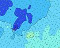 | 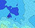 |  | 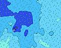 | 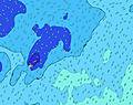 |  | ||||||||||||
Oleaje Altura (m) Dirección Período (s) | SE 8 | SE 8 | SE 8 | SE 9 | SE 9 | SE 9 | SE 8 | SE 8 | SE 9 | SE 9 | SE 9 | SE 9 | SE 9 | SE 9 | SE 9 | SE 9 | SE 9 | SE 9 | SE 9 |
Gráfico Olas | |||||||||||||||||||
1255 | 1407 | 1635 | 1610 | 1473 | 1277 | 1191 | 1220 | 1407 | 1580 | 1651 | 1651 | 1651 | 1575 | 1336 | 1271 | 1236 | 1236 | 1236 | |
Viento (km/h) | |||||||||||||||||||
Estado del Viento Viento de Mar Viento de Mar-Cruzado Cruzado Viento de Tierra-Cruzado Viento de Tierra Cristalino | cross-on | cross-on | cross-on | cross-on | cross-on | cross-on | cross-on | cross-on | cross-on | cross-on | cross-on | cross-on | cross-on | cross-on | cross-on | cross-on | cross-on | cross-on | cross-on |
Marea alta | 8:24PM1.23m | 8:44AM1.31m | 9:12PM1.18m | 9:32AM1.20m | |||||||||||||||
Marea baja | 2:27AM0.13m | 3:01PM0.15m | 3:17AM0.23m | 3:48PM0.24m | |||||||||||||||
— | — | — | — | 6:45 | — | — | — | — | — | — | — | 6:45 | — | — | — | — | — | — | |
6:25 | — | — | — | — | — | — | — | 6:25 | — | — | — | — | — | — | — | 6:25 | — | — | |
mm | 1 | — | — | — | — | — | — | — | — | — | — | — | — | — | — | — | 1 | 2 | 2 |
Temp. °C | 27 | 27 | 27 | 27 | 26 | 27 | 27 | 27 | 27 | 27 | 27 | 27 | 27 | 27 | 27 | 27 | 26 | 27 | 27 |
Enfriamiento °C | 22 | 22 | 22 | 23 | 22 | 23 | 23 | 23 | 22 | 22 | 23 | 23 | 23 | 23 | 23 | 24 | 23 | 25 | 24 |
Oleaje 1 Altura (m) Dirección Período (s) | WNW 14 | WNW 14 | WNW 14 | SSE 19 | SSE 19 | SSE 18 | SSE 18 | SSE 18 | SSE 17 | SSE 16 | SSE 16 | SSE 16 | SSE 16 | SSE 15 | SSE 15 | SSE 15 | SSE 15 | SSE 15 | SSE 14 |
75 | 73 | 71 | 146 | 243 | 289 | 395 | 390 | 459 | 412 | 487 | 481 | 463 | 434 | 417 | 491 | 485 | 522 | 478 | |
Oleaje 2 Altura (m) Dirección Período (s) | NE 8 | SSW 20 | SSW 19 | WNW 13 | SSW 19 | SW 18 | SSW 18 | SSW 18 | SSW 16 | SSW 16 | SSW 16 | SSW 17 | SSW 15 | SSW 16 | SSW 16 | SSW 16 | SSW 16 | SSW 16 | SSW 16 |
18 | 157 | 145 | 70 | 137 | 164 | 216 | 204 | 179 | 177 | 181 | 190 | 85 | 169 | 171 | 171 | 166 | 166 | 164 | |
Oleaje 3 Altura (m) Dirección Período (s) | SW 21 | NE 8 | NE 9 | SW 19 | WNW 13 | WNW 13 | NW 13 | NE 9 | NE 9 | NE 9 | WNW 13 | NE 9 | SSW 17 | WNW 13 | NE 9 | NE 9 | NE 9 | NE 8 | NE 8 |
109 | 18 | 21 | 91 | 70 | 70 | 46 | 20 | 21 | 21 | 34 | 12 | 119 | 33 | 19 | 20 | 19 | 11 | 18 | |
Olas de Viento Altura (m) Dirección Período (s) | SE 8 | SE 8 | SE 8 | SE 9 | SE 9 | SE 9 | SE 8 | SE 8 | SE 9 | SE 9 | SE 9 | SE 9 | SE 9 | SE 9 | SE 9 | SE 9 | SE 9 | SE 9 | SE 9 |
1255 | 1407 | 1635 | 1610 | 1473 | 1277 | 1191 | 1220 | 1407 | 1580 | 1651 | 1651 | 1651 | 1575 | 1336 | 1271 | 1236 | 1236 | 1236 | |
Viento del Tierra o Mar Limpio más proximo | |||||||||||||||||||
Distancia (km) | 1523 | 1521 | 1521 | 1521 | 1523 | 1523 | 1521 | 1521 | 1521 | 1523 | 1521 | 1521 | 1521 | 1521 | 1521 | 2002 | 2002 | 1521 | 1521 |
Mejores Olas Previstas en Tokelau | |||||||||||||||||||
Mejores Olas Previstas en Tokelau | |||||||||||||||||||
Busca-Olas Global | |||||||||||||||||||
- Map Icons:
 Break
Break Live Wave Height (m)
 Live Wind Speed (km/h)
 Surf Rating (10 Max)
 Ocean Swells (m)
- Wind Speed (km/h)
GRÁTIS! Un widget de Surf-Forecast.com para tu sitio
Este widget grátis de previsiones de surf y tiempo puede ser añadido a cualquier otro sitio y da un resumen de previsiones de olas para Utua Mamao (Atafu). Solo necesita cortar y pegar el código HTML de abajo en su web. Puede elegir preferencias de idioma y de unidades (métricas o imperiales) para convenir a los usuarios de su sitio. Clica aquí para obtener el código.
 Nearest