
Previsiones:

Pronóstico Corto PlazoFuerte lluvia (totál 36mm), más pesada durante la noche de lunes. Warm (max 27°C el lunes por la mañana, min 25°C el lunes por la noche). El viento será generalmente ligero. | |||||||||||||||||||||||
lunes 3 | martes 4 | miércoles 5 | |||||||||||||||||||||
4 AM | 7 AM | 10 AM | 1 PM | 4 PM | 7 PM | 10 PM | 1 AM | 4 AM | 7 AM | 10 AM | 1 PM | 4 PM | 7 PM | 10 PM | 1 AM | 4 AM | 7 AM | 10 AM | 1 PM | 4 PM | 7 PM | 10 PM | |
Mapa de Altura de Olas | 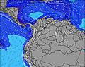 | 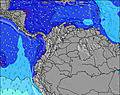 | 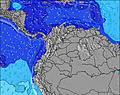 | 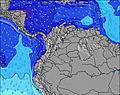 | 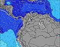 | 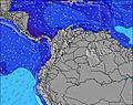 | 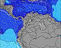 | 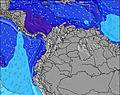 | 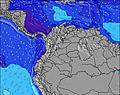 | ||||||||||||||
Oleaje Altura (m) Dirección Período (s) | SW 14 | SW 13 | SW 13 | SW 13 | SW 13 | SW 13 | SW 13 | SW 13 | SW 13 | SW 12 | SW 12 | WSW 5 | SW 12 | WSW 4 | WSW 5 | WSW 5 | WSW 5 | WSW 12 | WSW 12 | WSW 12 | W 5 | W 5 | W 5 |
Gráfico Olas | |||||||||||||||||||||||
47 | 46 | 45 | 45 | 45 | 44 | 44 | 43 | 42 | 24 | 24 | 18 | 23 | 20 | 22 | 23 | 22 | 14 | 16 | 15 | 15 | 15 | 12 | |
Viento (km/h) | |||||||||||||||||||||||
Estado del Viento Viento de Mar Viento de Mar-Cruzado Cruzado Viento de Tierra-Cruzado Viento de Tierra Cristalino | cross-off | cross-off | cross-off | cross | cross | cross-on | cross-off | cross-off | cross-off | cross-off | cross-off | cross | cross | cross | cross | cross-off | cross-off | cross-off | cross-off | cross | cross | cross-on | cross |
Marea alta | 6:34AM3.12m | 6:50PM2.89m | 7:11AM3.08m | 7:31PM2.80m | 7:52AM3.01m | 8:19PM2.70m | |||||||||||||||||
Marea baja | 12:47PM0.52m | 00:55AM0.50m | 1:26PM0.55m | 1:35AM0.60m | 2:12PM0.60m | ||||||||||||||||||
6:15 | — | — | — | — | — | — | — | 6:15 | — | — | — | — | — | — | — | 6:15 | — | — | — | — | — | — | |
— | — | — | — | 6:27 | — | — | — | — | — | — | — | 6:27 | — | — | — | — | — | — | — | 6:27 | — | — | |
mm | 1 | — | — | — | — | 2 | 5 | 2 | 1 | 1 | — | — | — | — | 3 | 5 | 4 | 3 | 1 | — | — | — | 2 |
Temp. °C | 25 | 25 | 27 | 27 | 27 | 26 | 26 | 25 | 25 | 25 | 26 | 27 | 27 | 26 | 26 | 25 | 25 | 25 | 26 | 27 | 27 | 26 | 26 |
Enfriamiento °C | 27 | 28 | 30 | 29 | 29 | 28 | 29 | 28 | 28 | 28 | 28 | 29 | 28 | 28 | 29 | 27 | 27 | 27 | 28 | 29 | 29 | 29 | 29 |
Oleaje 1 Altura (m) Dirección Período (s) | SW 14 | SW 13 | WSW 5 | SW 13 | SW 13 | SW 13 | SW 13 | SW 13 | SW 13 | SW 12 | SW 12 | WSW 12 | SW 12 | WSW 12 | WSW 12 | WSW 12 | WSW 12 | WSW 12 | WSW 12 | WSW 12 | WSW 11 | WSW 11 | W 5 |
47 | 46 | 30 | 45 | 45 | 44 | 44 | 43 | 42 | 24 | 24 | 15 | 23 | 14 | 14 | 14 | 14 | 14 | 13 | 13 | 13 | 13 | 11 | |
Oleaje 2 Altura (m) Dirección Período (s) | WNW 11 | WNW 11 | SW 13 | WNW 11 | WNW 11 | WNW 11 | WNW 11 | WNW 11 | WNW 11 | WNW 11 | WNW 10 | WNW 10 | WNW 10 | WNW 10 | WNW 10 | WNW 10 | WNW 10 | WNW 10 | WNW 10 | WNW 10 | NW 9 | NW 9 | WSW 11 |
24 | 24 | 45 | 25 | 24 | 23 | 22 | 11 | 11 | 11 | 10 | 10 | 10 | 10 | 10 | 10 | 10 | 10 | 9 | 9 | 3 | 3 | 12 | |
Oleaje 3 Altura (m) Dirección Período (s) | SW 11 | WSW 11 | WNW 11 | — | — | — | — | — | — | SW 10 | SW 10 | SW 10 | W 16 | W 16 | N 5 | SW 16 | SW 9 | SW 9 | SW 15 | SW 15 | SW 15 | SW 15 | NW 9 |
5 | 11 | 24 | — | — | — | — | — | — | 4 | 4 | 4 | 5 | 5 | 1 | 10 | 3 | 3 | 8 | 8 | 8 | 9 | 3 | |
Olas de Viento Altura (m) Dirección Período (s) | WSW 5 | WSW 5 | — | WSW 5 | WSW 5 | WSW 5 | WSW 5 | WSW 5 | WSW 5 | WSW 5 | WSW 5 | WSW 5 | W 5 | WSW 4 | WSW 5 | WSW 5 | WSW 5 | WSW 4 | WSW 4 | W 4 | W 5 | W 5 | — |
41 | 41 | — | 21 | 28 | 37 | 37 | 26 | 24 | 25 | 26 | 18 | 17 | 20 | 22 | 23 | 22 | 22 | 16 | 15 | 15 | 15 | — | |
Viento del Tierra o Mar Limpio más proximo | |||||||||||||||||||||||
Distancia (km) | 0 | 0 | 0 | 640 | 630 | 632 | 0 | 0 | 0 | 159 | 151 | 640 | 871 | 633 | 477 | 0 | 275 | 194 | 194 | 436 | 436 | 436 | 436 |
Mejores Olas Previstas en Pacific Coast | |||||||||||||||||||||||
Mejores Olas Previstas en Colombia | |||||||||||||||||||||||
Busca-Olas Global | |||||||||||||||||||||||
- Map Icons:
 Break
Break Live Wave Height (m)
 Live Wind Speed (km/h)
 Surf Rating (10 Max)
 Ocean Swells (m)
- Wind Speed (km/h)
GRÁTIS! Un widget de Surf-Forecast.com para tu sitio
Este widget grátis de previsiones de surf y tiempo puede ser añadido a cualquier otro sitio y da un resumen de previsiones de olas para Tumaco. Solo necesita cortar y pegar el código HTML de abajo en su web. Puede elegir preferencias de idioma y de unidades (métricas o imperiales) para convenir a los usuarios de su sitio. Clica aquí para obtener el código.
 Nearest