
Previsiones:

Pronóstico Corto PlazoAlgo de llovizna, más pesada durante la tarde de jueves. Warm (max 26°C el viernes por la tarde, min 21°C el jueves por la mañana). El viento será generalmente ligero. | ||||||||||||||||||||||||
jueves 30 | viernes 31 | sábado 1 | ||||||||||||||||||||||
2 AM | 5 AM | 8 AM | 11 AM | 2 PM | 5 PM | 8 PM | 11 PM | 2 AM | 5 AM | 8 AM | 11 AM | 2 PM | 5 PM | 8 PM | 11 PM | 2 AM | 5 AM | 8 AM | 11 AM | 2 PM | 5 PM | 8 PM | 11 PM | |
Mapa de Altura de Olas | 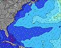 | 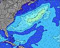 | 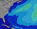 | 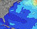 | 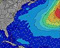 | 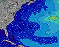 | 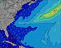 | 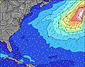 | 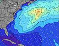 | |||||||||||||||
Oleaje Altura (m) Dirección Período (s) | SSE 7 | SE 7 | SE 7 | SE 8 | SE 8 | SSE 8 | SSE 8 | SSE 8 | SSE 8 | SSE 8 | SSE 8 | SSE 8 | SSE 8 | SE 8 | SSE 9 | SSE 9 | SSE 9 | SSE 8 | SSE 8 | SSE 7 | SSE 7 | SSE 7 | S 7 | S 3 |
Gráfico Olas | ||||||||||||||||||||||||
36 | 24 | 12 | 33 | 31 | 23 | 23 | 23 | 23 | 23 | 27 | 26 | 26 | 16 | 17 | 32 | 31 | 27 | 13 | 11 | 10 | 16 | 23 | 8 | |
Viento (km/h) | ||||||||||||||||||||||||
Estado del Viento Viento de Mar Viento de Mar-Cruzado Cruzado Viento de Tierra-Cruzado Viento de Tierra Cristalino | off | off | off | off | off | cross-off | cross-on | on | cross-on | cross-off | cross-off | off | cross-off | cross-on | cross-on | cross-on | cross | cross-off | cross | cross-on | on | cross-on | cross-on | cross-on |
Marea alta | 9:17AM1.33m | 9:25PM1.58m | 9:53AM1.35m | 10:00PM1.55m | 10:30AM1.38m | 10:36PM1.51m | ||||||||||||||||||
Marea baja | 3:01AM0.02m | 3:02PM0.14m | 3:37AM-0.00m | 3:42PM0.14m | 4:12AM-0.01m | 4:21PM0.15m | ||||||||||||||||||
— | 5:58 | — | — | — | — | — | — | — | 5:58 | — | — | — | — | — | — | — | 5:58 | — | — | — | — | — | — | |
— | — | — | — | — | — | 8:13 | — | — | — | — | — | — | — | 8:12 | — | — | — | — | — | — | — | 8:10 | — | |
mm | — | — | — | — | — | 1 | — | — | — | — | — | — | — | — | — | — | — | — | — | — | — | — | — | — |
Temp. °C | 22 | 22 | 21 | 23 | 25 | 24 | 23 | 23 | 22 | 22 | 22 | 23 | 25 | 26 | 25 | 24 | 24 | 23 | 24 | 25 | 25 | 25 | 25 | 25 |
Enfriamiento °C | 19 | 19 | 17 | 19 | 23 | 25 | 24 | 25 | 23 | 24 | 24 | 25 | 26 | 26 | 25 | 24 | 24 | 23 | 26 | 26 | 24 | 23 | 24 | 24 |
Oleaje 1 Altura (m) Dirección Período (s) | SSE 7 | SE 7 | SE 7 | SE 8 | SE 8 | SSE 8 | SSE 8 | SSE 8 | SSE 8 | SSE 8 | SSE 8 | SSE 8 | SSE 8 | SE 8 | ENE 6 | SSE 9 | SSE 9 | SSE 8 | SSE 8 | SSE 7 | SSE 7 | SE 9 | SE 8 | SE 8 |
36 | 24 | 12 | 33 | 31 | 23 | 23 | 23 | 23 | 23 | 27 | 26 | 26 | 16 | 3 | 32 | 31 | 27 | 13 | 11 | 10 | 3 | 3 | 3 | |
Oleaje 2 Altura (m) Dirección Período (s) | E 6 | E 6 | SE 8 | ENE 8 | E 7 | WNW 3 | — | ENE 6 | ENE 6 | ENE 6 | ENE 6 | ENE 6 | ENE 5 | ENE 6 | NE 6 | ENE 6 | ENE 6 | S 3 | SSW 3 | S 3 | SE 9 | E 6 | E 6 | E 6 |
1 | 1 | 11 | 6 | 1 | 2 | — | 6 | 6 | 6 | 6 | 6 | 6 | 3 | 9 | 3 | 3 | 2 | 2 | 1 | 3 | 1 | 1 | 1 | |
Oleaje 3 Altura (m) Dirección Período (s) | E 8 | E 8 | E 8 | — | E 8 | E 7 | E 6 | — | — | — | — | — | — | SE 9 | SSE 9 | SE 9 | ESE 9 | E 6 | SE 8 | SE 9 | E 6 | NE 6 | — | S 9 |
1 | 1 | 1 | — | 1 | 1 | 1 | — | — | — | — | — | — | 3 | 17 | 3 | 7 | 3 | 3 | 3 | 1 | 1 | — | 2 | |
Olas de Viento Altura (m) Dirección Período (s) | NW 4 | NW 4 | NW 4 | NW 4 | WNW 3 | NW 3 | — | — | — | — | — | — | — | — | — | SSW 3 | SSW 3 | — | SW 3 | — | S 3 | SSE 7 | S 7 | S 3 |
11 | 13 | 14 | 14 | 5 | 3 | — | — | — | — | — | — | — | — | — | 3 | 3 | — | 3 | — | 1 | 16 | 23 | 8 | |
Viento del Tierra o Mar Limpio más proximo | ||||||||||||||||||||||||
Distancia (km) | 34 | 94 | 69 | 34 | 210 | 34 | 207 | 83 | 83 | 100 | 100 | 104 | 320 | 348 | 348 | 73 | 33 | 34 | 100 | 160 | 375 | 1011 | 1013 | 555 |
Mejores Olas Previstas en New Jersey | ||||||||||||||||||||||||
Mejores Olas Previstas en United States | ||||||||||||||||||||||||
Busca-Olas Global | ||||||||||||||||||||||||
- Map Icons:
 Break
Break Live Wave Height (m)
 Live Wind Speed (km/h)
 Surf Rating (10 Max)
 Ocean Swells (m)
- Wind Speed (km/h)
GRÁTIS! Un widget de Surf-Forecast.com para tu sitio
Este widget grátis de previsiones de surf y tiempo puede ser añadido a cualquier otro sitio y da un resumen de previsiones de olas para Trestles. Solo necesita cortar y pegar el código HTML de abajo en su web. Puede elegir preferencias de idioma y de unidades (métricas o imperiales) para convenir a los usuarios de su sitio. Clica aquí para obtener el código.
 Nearest