
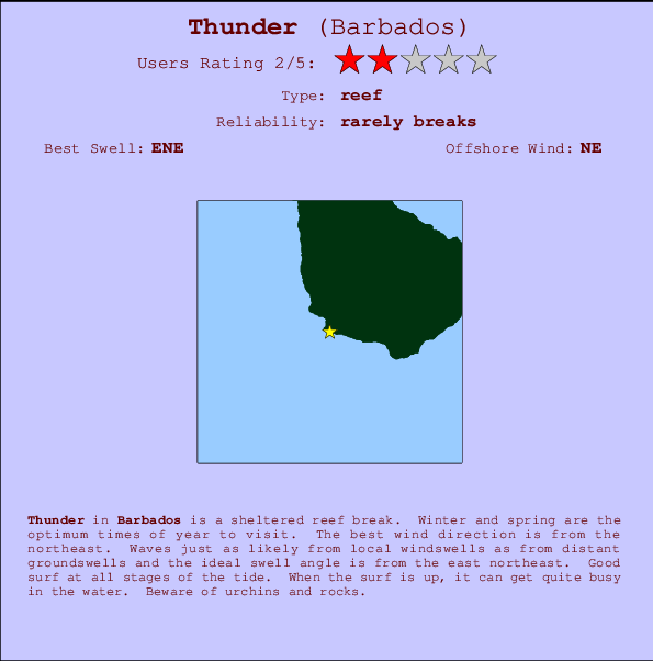
Thunder Surf Guide
Thunder on the West Coast is a sheltered reef break. Winter and spring are the favoured times of year to visit. Offshore winds are from the northeast. Groundswells and windswells are equally likely and the ideal swell direction is from the east northeast. Reef breaks provide lefts and rights. When the surf is up, it can get quite busy in the water. Beware of urchins and rocks.
Thunder Spot Info
| Type: | Rating: | Reliability: | Todays Sea Temp*: |
|---|---|---|---|
| rarely breaks | 28.3°C*ocean temperature recorded from satellite |
Surfing Thunder:
The best conditions reported for surf at Thunder occur when a East-northeast swell combines with an offshore wind direction from the Northeast.

Energía de Olas (poder): 12 horas


Thunder Surf:
Sunday, 26 July 2026, 19:17 Local time| domingo 26 | lun | |||
| 5PM | 8PM | 11PM | 2AM | |
| Wave (m) | ||||
| Período (s) | 9 | 9 | 9 | 9 |
| Viento (km/h) | ||||
| Estado del Viento | cross- off |
cross- off |
cross- off |
cross- off |
- /breaks/Thunder/forecasts/latest
Thunder Surf Guide
Thunder on the West Coast is a sheltered reef break. Winter and spring are the favoured times of year to visit. Offshore winds are from the northeast. Groundswells and windswells are equally likely and the ideal swell direction is from the east northeast. Reef breaks provide lefts and rights. When the surf is up, it can get quite busy in the water. Beware of urchins and rocks.
Thunder Spot Info
Type: Rating: Reliability: Todays Sea Temp*:  Reef
Reef 2
2rarely breaks 28.3°C*ocean temperature recorded from satelliteSurfing Thunder:
The best conditions reported for surf at Thunder occur when a East-northeast swell combines with an offshore wind direction from the Northeast.
Energía de Olas (poder): 12 horas
Usa la barra de navegación de arriba para ver la temperatura del mar en Thunder, fotografías Thunder, previsiones detalladas de olas para Thunder, vientos y previsión del tiempo, webcams para Thunder, viento actual desde estaciones meteorológicas en Barbados y predicciones de marea para Thunder. Las mapas de olas para Barbados enseñarán un mapa grande de Barbados y los mares que rodean. Los mapas de olas pueden ser animadas para mostrar diferentes componentes de olas, la altura de ola, la energía de ola, el período, junto con previsiones de viento y del tiempo. Previsiones actuales del tiempo y del estado del mar provienen de boyas marinas de Barbados, del barcos que transitan en la zona y de estaciones meteorológicas costeras. Cada página de previsiones tiene un Busca-Olas Regional y Global para localizar las mejores condiciones para surfear en el área de Thunder.
Thunder Surf:
Sunday, 26 July 2026, 19:17 Local timedomingo 26 lun 5PM 8PM 11PM 2AM Wave (m) Período (s) 9 9 9 9 Viento (km/h) Estado del Viento cross-
offcross-
offcross-
offcross-
off- /breaks/Thunder/forecasts/latest
- /breaks/Thunder/forecasts/latest/six_day
Thunder Surf Guide
Thunder on the West Coast is a sheltered reef break. Winter and spring are the favoured times of year to visit. Offshore winds are from the northeast. Groundswells and windswells are equally likely and the ideal swell direction is from the east northeast. Reef breaks provide lefts and rights. When the surf is up, it can get quite busy in the water. Beware of urchins and rocks.
Thunder Spot Info
Type: Rating: Reliability: Todays Sea Temp*: Reef2rarely breaks 28.3°C*ocean temperature recorded from satelliteSurfing Thunder:
The best conditions reported for surf at Thunder occur when a East-northeast swell combines with an offshore wind direction from the Northeast.
Energía de Olas (poder): 12 horas
Usa la barra de navegación de arriba para ver la temperatura del mar en Thunder, fotografías Thunder, previsiones detalladas de olas para Thunder, vientos y previsión del tiempo, webcams para Thunder, viento actual desde estaciones meteorológicas en Barbados y predicciones de marea para Thunder. Las mapas de olas para Barbados enseñarán un mapa grande de Barbados y los mares que rodean. Los mapas de olas pueden ser animadas para mostrar diferentes componentes de olas, la altura de ola, la energía de ola, el período, junto con previsiones de viento y del tiempo. Previsiones actuales del tiempo y del estado del mar provienen de boyas marinas de Barbados, del barcos que transitan en la zona y de estaciones meteorológicas costeras. Cada página de previsiones tiene un Busca-Olas Regional y Global para localizar las mejores condiciones para surfear en el área de Thunder.
Thunder Surf:
Sunday, 26 July 2026, 19:17 Local timedomingo 26 lun 5PM 8PM 11PM 2AM Wave (m) Período (s) 9 9 9 9 Viento (km/h) Estado del Viento cross-
offcross-
offcross-
offcross-
off- /breaks/Thunder/forecasts/latest
Thunder Surf Guide
Thunder on the West Coast is a sheltered reef break. Winter and spring are the favoured times of year to visit. Offshore winds are from the northeast. Groundswells and windswells are equally likely and the ideal swell direction is from the east northeast. Reef breaks provide lefts and rights. When the surf is up, it can get quite busy in the water. Beware of urchins and rocks.
Thunder Spot Info
Type: Rating: Reliability: Todays Sea Temp*: Reef2rarely breaks 28.3°C*ocean temperature recorded from satelliteSurfing Thunder:
The best conditions reported for surf at Thunder occur when a East-northeast swell combines with an offshore wind direction from the Northeast.
Energía de Olas (poder): 12 horas
Usa la barra de navegación de arriba para ver la temperatura del mar en Thunder, fotografías Thunder, previsiones detalladas de olas para Thunder, vientos y previsión del tiempo, webcams para Thunder, viento actual desde estaciones meteorológicas en Barbados y predicciones de marea para Thunder. Las mapas de olas para Barbados enseñarán un mapa grande de Barbados y los mares que rodean. Los mapas de olas pueden ser animadas para mostrar diferentes componentes de olas, la altura de ola, la energía de ola, el período, junto con previsiones de viento y del tiempo. Previsiones actuales del tiempo y del estado del mar provienen de boyas marinas de Barbados, del barcos que transitan en la zona y de estaciones meteorológicas costeras. Cada página de previsiones tiene un Busca-Olas Regional y Global para localizar las mejores condiciones para surfear en el área de Thunder.
Thunder Surf:
Sunday, 26 July 2026, 19:17 Local timedomingo 26 lun 5PM 8PM 11PM 2AM Wave (m) Período (s) 9 9 9 9 Viento (km/h) Estado del Viento cross-
offcross-
offcross-
offcross-
offTide Times:
Para Bridgetown, Barbados, a %{dist} %{km} de %{location}.
PROXIMA ES A LAS (hora local) quedan marea alta marea baja Thunder Tide Times and Tide Chart
Live Weather:
At Grantley Adams International Airport, 13 km from Thunder.
moderate winds from the ENE
(km/h)
no reportAir temperature
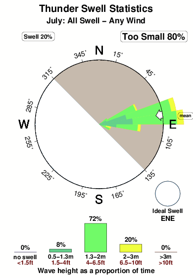
27.4°COverall Thunder Surf Consistency and Wind Distribution in julio
Fotos de Surf
de la galeríaContornos: Carreteras y Ríos: Selecciona un spot desde el menú 
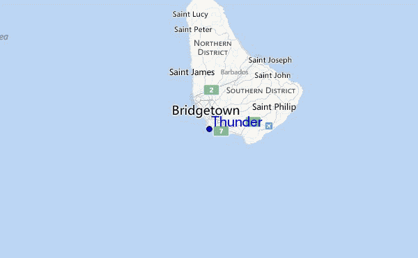
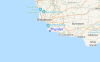
Usa este mapa para navegar hacia las playas de surf de Barbados y estaciones de marea cercanas de Thunder
Spots de Surf más cercanos a Thunder:
(Clica la ubicación para más detalles)- Closest spot1 mi
- Second closest spot1 mi
- Third closest spot2 mi
- Fourth closest spot2 mi
- Fifth closest spot4 mi
Boyas marinas más cercanas a Thunder:
- Closest Boya Marinas252 mi
- Second closest Boya Marinas352 mi
- Third closest Boya Marinas454 mi
- Fourth closest Boya Marinas495 mi
- Fifth closest Boya Marinas529 mi
Estaciones de marea más cercanas a Thunder:
- Closest estación de mareaBridgetown, Barbados2 mi
- Second closest estación de mareaVieux Fort Bay102 mi
- Third closest estación de mareaKingstown, Saint Vincent109 mi
- Fourth closest estación de mareaBisee112 mi
- Fifth closest estación de mareaPort Castries114 mi
Airports
- The closest passenger airport to Thunder is Grantley Adams International (Bridgetown) Airport (BGI) in Barbados, 12 km (7 miles) away (directly).
- The second nearest airport to Thunder is Hewanorra International (Hewandorra) Airport (UVF) in St. Lucia Island, 163 km (101 miles) away.
- Third is Mustique Airport (MQS) in St.vincent/grenadines, 172 km (107 miles) away.
- E T Joshua (Kingstown) Airport (SVD) in St.vincent/grenadines is 174 km (108 miles) away.
- George F L Charles (Castries) Airport (SLU) in St. Lucia Island is the fifth nearest airport to Thunder and is 183 km (114 miles) away.
- /breaks/Thunder/forecasts/latest


 Nearest