

30th Street/Ship Bottom Surf Guide
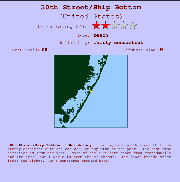
30th Street/Ship Bottom in New Jersey is an exposed beach break that has fairly consistent surf and can work at any time of the year. Offshore winds are from the west. Most of the surf here comes from groundswells and the best swell direction is from the southeast. Waves at the beach break both left and right. When it's working here, it can get crowded.
30th Street/Ship Bottom Spot Info
| Type: | Rating: | Reliability: | Todays Sea Temp*: |
|---|---|---|---|
| fairly consistent | 24.6°C*ocean temperature recorded from satellite |
Surfing 30th Street/Ship Bottom:
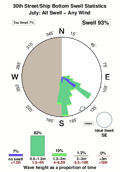
The best conditions reported for surf at 30th Street/Ship Bottom occur when a Southeast swell combines with an offshore wind direction from the West.

Energía de Olas (poder): 12 horas


30th Street/Ship Bottom Surf:
Tuesday, 14 July 2026, 23:29 Local time| mar | miércoles 15 | |||
| 11PM | 2AM | 5AM | 8AM | |
| Wave (m) | ||||
| Período (s) | 9 | 9 | 5 | 5 |
| Viento (km/h) | ||||
| Estado del Viento | cross- off |
cross- off |
cross- off |
off |
- /breaks/Thirtith-Street/forecasts/latest
30th Street/Ship Bottom Surf Guide
30th Street/Ship Bottom in New Jersey is an exposed beach break that has fairly consistent surf and can work at any time of the year. Offshore winds are from the west. Most of the surf here comes from groundswells and the best swell direction is from the southeast. Waves at the beach break both left and right. When it's working here, it can get crowded.
30th Street/Ship Bottom Spot Info
Type: Rating: Reliability: Todays Sea Temp*:  Beach
Beach 2
2fairly consistent 24.6°C*ocean temperature recorded from satelliteSurfing 30th Street/Ship Bottom:
The best conditions reported for surf at 30th Street/Ship Bottom occur when a Southeast swell combines with an offshore wind direction from the West.
Energía de Olas (poder): 12 horas
Usa la barra de navegación de arriba para ver la temperatura del mar en 30th Street/Ship Bottom, fotografías 30th Street/Ship Bottom, previsiones detalladas de olas para 30th Street/Ship Bottom, vientos y previsión del tiempo, webcams para 30th Street/Ship Bottom, viento actual desde estaciones meteorológicas en New Jersey y predicciones de marea para 30th Street/Ship Bottom. Las mapas de olas para United States enseñarán un mapa grande de United States y los mares que rodean. Los mapas de olas pueden ser animadas para mostrar diferentes componentes de olas, la altura de ola, la energía de ola, el período, junto con previsiones de viento y del tiempo. Previsiones actuales del tiempo y del estado del mar provienen de boyas marinas de United States, del barcos que transitan en la zona y de estaciones meteorológicas costeras. Cada página de previsiones tiene un Busca-Olas Regional y Global para localizar las mejores condiciones para surfear en el área de 30th Street/Ship Bottom.
30th Street/Ship Bottom Surf:
Tuesday, 14 July 2026, 23:29 Local timemar miércoles 15 11PM 2AM 5AM 8AM Wave (m) Período (s) 9 9 5 5 Viento (km/h) Estado del Viento cross-
offcross-
offcross-
offoff - /breaks/Thirtith-Street/forecasts/latest
- /breaks/Thirtith-Street/forecasts/latest/six_day
30th Street/Ship Bottom Surf Guide
30th Street/Ship Bottom in New Jersey is an exposed beach break that has fairly consistent surf and can work at any time of the year. Offshore winds are from the west. Most of the surf here comes from groundswells and the best swell direction is from the southeast. Waves at the beach break both left and right. When it's working here, it can get crowded.
30th Street/Ship Bottom Spot Info
Type: Rating: Reliability: Todays Sea Temp*: Beach2fairly consistent 24.6°C*ocean temperature recorded from satelliteSurfing 30th Street/Ship Bottom:
The best conditions reported for surf at 30th Street/Ship Bottom occur when a Southeast swell combines with an offshore wind direction from the West.
Energía de Olas (poder): 12 horas
Usa la barra de navegación de arriba para ver la temperatura del mar en 30th Street/Ship Bottom, fotografías 30th Street/Ship Bottom, previsiones detalladas de olas para 30th Street/Ship Bottom, vientos y previsión del tiempo, webcams para 30th Street/Ship Bottom, viento actual desde estaciones meteorológicas en New Jersey y predicciones de marea para 30th Street/Ship Bottom. Las mapas de olas para United States enseñarán un mapa grande de United States y los mares que rodean. Los mapas de olas pueden ser animadas para mostrar diferentes componentes de olas, la altura de ola, la energía de ola, el período, junto con previsiones de viento y del tiempo. Previsiones actuales del tiempo y del estado del mar provienen de boyas marinas de United States, del barcos que transitan en la zona y de estaciones meteorológicas costeras. Cada página de previsiones tiene un Busca-Olas Regional y Global para localizar las mejores condiciones para surfear en el área de 30th Street/Ship Bottom.
30th Street/Ship Bottom Surf:
Tuesday, 14 July 2026, 23:29 Local timemar miércoles 15 11PM 2AM 5AM 8AM Wave (m) Período (s) 9 9 5 5 Viento (km/h) Estado del Viento cross-
offcross-
offcross-
offoff - /breaks/Thirtith-Street/forecasts/latest
30th Street/Ship Bottom Surf Guide
30th Street/Ship Bottom in New Jersey is an exposed beach break that has fairly consistent surf and can work at any time of the year. Offshore winds are from the west. Most of the surf here comes from groundswells and the best swell direction is from the southeast. Waves at the beach break both left and right. When it's working here, it can get crowded.
30th Street/Ship Bottom Spot Info
Type: Rating: Reliability: Todays Sea Temp*: Beach2fairly consistent 24.6°C*ocean temperature recorded from satelliteSurfing 30th Street/Ship Bottom:
The best conditions reported for surf at 30th Street/Ship Bottom occur when a Southeast swell combines with an offshore wind direction from the West.
Energía de Olas (poder): 12 horas
Usa la barra de navegación de arriba para ver la temperatura del mar en 30th Street/Ship Bottom, fotografías 30th Street/Ship Bottom, previsiones detalladas de olas para 30th Street/Ship Bottom, vientos y previsión del tiempo, webcams para 30th Street/Ship Bottom, viento actual desde estaciones meteorológicas en New Jersey y predicciones de marea para 30th Street/Ship Bottom. Las mapas de olas para United States enseñarán un mapa grande de United States y los mares que rodean. Los mapas de olas pueden ser animadas para mostrar diferentes componentes de olas, la altura de ola, la energía de ola, el período, junto con previsiones de viento y del tiempo. Previsiones actuales del tiempo y del estado del mar provienen de boyas marinas de United States, del barcos que transitan en la zona y de estaciones meteorológicas costeras. Cada página de previsiones tiene un Busca-Olas Regional y Global para localizar las mejores condiciones para surfear en el área de 30th Street/Ship Bottom.
30th Street/Ship Bottom Surf:
Tuesday, 14 July 2026, 23:29 Local timemar miércoles 15 11PM 2AM 5AM 8AM Wave (m) Período (s) 9 9 5 5 Viento (km/h) Estado del Viento cross-
offcross-
offcross-
offoff Tide Times:
Para Seaside Heights, ocean, New Jersey, a %{dist} %{km} de %{location}.
PROXIMA ES A LAS (hora local) quedan marea alta marea baja 30th Street/Ship Bottom Tide Times and Tide Chart
Live Weather:
At BUOY-JCRN4, 26 km from 30th Street/Ship Bottom.
light winds from the S
(km/h)Air temperature
26.5°COverall 30th Street/Ship Bottom Surf Consistency and Wind Distribution in julio
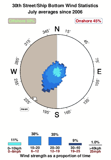


Wind stats for 30th Street/Ship Bottom: see the variation in direction and stength by month.
Fotos de Surf
de la galeríaContornos: Carreteras y Ríos: Selecciona un spot desde el menú 


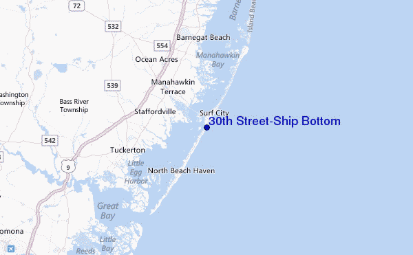
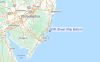
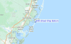
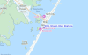
Usa este mapa para navegar hacia las playas de surf de New Jersey y estaciones de marea cercanas de 30th Street/Ship Bottom
Spots de Surf más cercanos a 30th Street/Ship Bottom:
(Clica la ubicación para más detalles)- Closest spot1 mi
- Second closest spot2 mi
- Third closest spot2 mi
- Fourth closest spot4 mi
- Fifth closest spot4 mi
Boyas marinas más cercanas a 30th Street/Ship Bottom:
- Closest Boya Marinas2 mi
- Second closest Boya Marinas24 mi
- Third closest Boya Marinas57 mi
- Fourth closest Boya Marinas68 mi
- Fifth closest Boya Marinas85 mi
Estaciones de marea más cercanas a 30th Street/Ship Bottom:
- Closest estación de mareaManahawkin Drawbridge, Manahawkin Bay1 mi
- Second closest estación de mareaBeach Haven Crest2 mi
- Third closest estación de mareaManahawkin Creek, Manahawkin Bay2 mi
- Fourth closest estación de mareaMill Creek, 1 nautical miles above entrance3 mi
- Fifth closest estación de mareaNorth Beach, Manahawkin Bay3 mi
Airports
- The closest passenger airport to 30th Street/Ship Bottom is Atlantic City International Airport (ACY) in USA, 39 km (24 miles) away (directly).
- The second nearest airport to 30th Street/Ship Bottom is Lakehurst Naes Airport (NEL), also in USA, 46 km (29 miles) away.
- Third is Mc Guire Afb (Wrightstown) Airport (WRI) in USA, 55 km (34 miles) away.
- Millville Muni Airport (MIV) in USA is 82 km (51 miles) away.
- Northeast Philadelphia Airport (PNE), also in USA is the fifth nearest airport to 30th Street/Ship Bottom and is 86 km (53 miles) away.
- /breaks/Thirtith-Street/forecasts/latest
 Nearest