
Previsiones:

Pronóstico Corto PlazoFuerte lluvia (totál 56mm), más pesada durante la noche de miércoles. Warm (max 28°C el miércoles por la mañana, min 27°C el martes por la noche). El viento será generalmente ligero. | ||||||||||||||||||
mar 28 | miércoles 29 | jueves 30 | ||||||||||||||||
8 PM | 11 PM | 2 AM | 5 AM | 8 AM | 11 AM | 2 PM | 5 PM | 8 PM | 11 PM | 2 AM | 5 AM | 8 AM | 11 AM | 2 PM | 5 PM | 8 PM | 11 PM | |
Mapa de Altura de Olas |  | 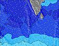 | 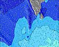 | 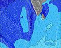 | 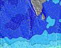 | 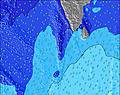 | 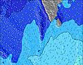 | |||||||||||
Oleaje Altura (m) Dirección Período (s) | SSW 16 | SSW 16 | SSW 16 | SSW 15 | SSW 15 | SSW 14 | SSW 21 | SSW 20 | SSW 20 | SSW 14 | SSW 19 | SSW 18 | SSW 18 | SSW 18 | SSW 18 | SSW 18 | SSW 17 | SSW 16 |
Gráfico Olas | ||||||||||||||||||
277 | 256 | 253 | 228 | 222 | 371 | 339 | 349 | 301 | 189 | 329 | 464 | 454 | 454 | 356 | 352 | 414 | 412 | |
Viento (km/h) | ||||||||||||||||||
Estado del Viento Viento de Mar Viento de Mar-Cruzado Cruzado Viento de Tierra-Cruzado Viento de Tierra Cristalino | cross-on | cross-on | cross-on | cross-on | cross-on | cross | cross | cross | cross-on | cross-on | cross-on | cross-on | cross-on | cross-on | cross-on | cross-on | cross-on | cross-on |
Marea alta | 2:44AM0.43m | 2:37PM0.53m | 3:09AM0.46m | 3:03PM0.55m | ||||||||||||||
Marea baja | 8:42PM0.06m | 8:25AM0.11m | 9:05PM0.03m | 8:54AM0.09m | 9:27PM0.01m | |||||||||||||
— | — | — | 6:03 | — | — | — | — | — | — | — | 6:03 | — | — | — | — | — | — | |
— | — | — | — | — | — | — | 6:25 | — | — | — | — | — | — | — | 6:25 | — | — | |
mm | 1 | 1 | 2 | 2 | 2 | 3 | 2 | 2 | 2 | 2 | 4 | 3 | 2 | 2 | 2 | 2 | 2 | 3 |
Temp. °C | 27 | 27 | 27 | 27 | 27 | 28 | 28 | 27 | 27 | 27 | 27 | 27 | 27 | 28 | 28 | 27 | 27 | 27 |
Enfriamiento °C | 29 | 28 | 28 | 28 | 28 | 29 | 29 | 28 | 29 | 29 | 28 | 28 | 28 | 29 | 29 | 28 | 28 | 28 |
Oleaje 1 Altura (m) Dirección Período (s) | SSW 16 | SSW 16 | SSW 16 | SSW 15 | SSW 15 | SSW 14 | SSW 14 | SSW 14 | SSW 14 | W 9 | SSW 13 | SSW 13 | SSW 18 | SSW 13 | SSW 13 | SSW 12 | SSW 17 | SSW 16 |
277 | 256 | 253 | 228 | 222 | 371 | 215 | 213 | 204 | 103 | 184 | 290 | 454 | 222 | 212 | 202 | 414 | 412 | |
Oleaje 2 Altura (m) Dirección Período (s) | SSW 5 | W 9 | W 9 | SSW 5 | W 9 | W 9 | W 9 | W 9 | W 9 | SSW 14 | W 9 | SSW 18 | SSW 13 | SSW 18 | SSW 18 | SSW 18 | SSW 12 | SSW 12 |
30 | 62 | 64 | 22 | 62 | 81 | 81 | 83 | 81 | 189 | 85 | 464 | 286 | 454 | 356 | 352 | 195 | 147 | |
Oleaje 3 Altura (m) Dirección Período (s) | W 9 | SSW 11 | S 11 | W 9 | SSE 10 | SSW 21 | SSW 21 | SSW 20 | SSW 20 | SSW 6 | SSW 19 | W 9 | W 9 | W 9 | W 9 | W 9 | W 9 | W 9 |
62 | 69 | 59 | 64 | 38 | 258 | 339 | 349 | 301 | 27 | 329 | 85 | 85 | 83 | 63 | 60 | 61 | 43 | |
Olas de Viento Altura (m) Dirección Período (s) | W 6 | WSW 6 | WSW 6 | W 6 | WSW 6 | WSW 6 | WSW 6 | W 7 | WSW 6 | W 7 | WSW 6 | WSW 6 | WSW 7 | WSW 7 | WSW 6 | WSW 6 | WSW 6 | WSW 6 |
75 | 115 | 111 | 109 | 146 | 144 | 165 | 131 | 149 | 85 | 129 | 129 | 137 | 145 | 161 | 146 | 146 | 161 | |
Viento del Tierra o Mar Limpio más proximo | ||||||||||||||||||
Distancia (km) | 1361 | 1931 | 875 | 875 | 740 | 193 | 193 | 192 | 875 | 875 | 875 | 875 | 194 | 193 | 193 | 875 | 875 | 875 |
Mejores Olas Previstas en West Sri Lanka | ||||||||||||||||||
Mejores Olas Previstas en Sri Lanka | ||||||||||||||||||
Busca-Olas Global | ||||||||||||||||||
- Map Icons:
 Break
Break Live Wave Height (m)
 Live Wind Speed (km/h)
 Surf Rating (10 Max)
 Ocean Swells (m)
- Wind Speed (km/h)
GRÁTIS! Un widget de Surf-Forecast.com para tu sitio
Este widget grátis de previsiones de surf y tiempo puede ser añadido a cualquier otro sitio y da un resumen de previsiones de olas para The Rock. Solo necesita cortar y pegar el código HTML de abajo en su web. Puede elegir preferencias de idioma y de unidades (métricas o imperiales) para convenir a los usuarios de su sitio. Clica aquí para obtener el código.
 Nearest