
The Ledge Surf Guide
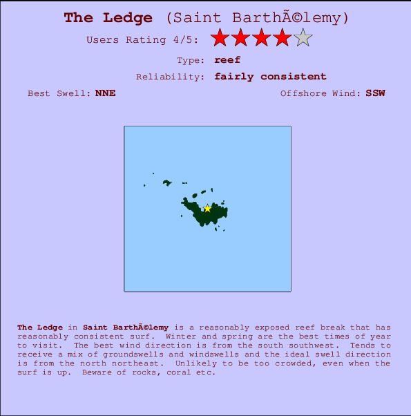
The Ledge on the North Coast is a fairly exposed reef break that has reasonably consistent surf. Winter and spring are the best times of year to visit. Works best in offshore winds from the south southwest. Tends to receive a mix of groundswells and windswells and the best swell direction is from the north northeast. A choice of left and right reefs. Rarely crowded here. Beware of rocks, coral etc.
The Ledge Spot Info
| Type: | Rating: | Reliability: | Todays Sea Temp*: |
|---|---|---|---|
| fairly consistent | 28.2°C*ocean temperature recorded from satellite |
Surfing The Ledge:
The best conditions reported for surf at The Ledge occur when a North-northeast swell combines with an offshore wind direction from the South-southwest.

Energía de Olas (poder): 12 horas


The Ledge Surf:
Tuesday, 14 July 2026, 15:51 Local time| martes 14 | mié | |||
| 5PM | 8PM | 11PM | 2AM | |
| Wave (m) | ||||
| Período (s) | 8 | 8 | 8 | 7 |
| Viento (km/h) | ||||
| Estado del Viento | cross- on |
cross- on |
cross- on |
cross- on |
- /breaks/The-Ledge/forecasts/latest
The Ledge Surf Guide
The Ledge on the North Coast is a fairly exposed reef break that has reasonably consistent surf. Winter and spring are the best times of year to visit. Works best in offshore winds from the south southwest. Tends to receive a mix of groundswells and windswells and the best swell direction is from the north northeast. A choice of left and right reefs. Rarely crowded here. Beware of rocks, coral etc.
The Ledge Spot Info
Type: Rating: Reliability: Todays Sea Temp*:  Reef
Reef 4
4fairly consistent 28.2°C*ocean temperature recorded from satelliteSurfing The Ledge:
The best conditions reported for surf at The Ledge occur when a North-northeast swell combines with an offshore wind direction from the South-southwest.
Energía de Olas (poder): 12 horas
Usa la barra de navegación de arriba para ver la temperatura del mar en The Ledge, fotografías The Ledge, previsiones detalladas de olas para The Ledge, vientos y previsión del tiempo, webcams para The Ledge, viento actual desde estaciones meteorológicas en Saint Barthélemy y predicciones de marea para The Ledge. Las mapas de olas para Saint Barthélemy enseñarán un mapa grande de Saint Barthélemy y los mares que rodean. Los mapas de olas pueden ser animadas para mostrar diferentes componentes de olas, la altura de ola, la energía de ola, el período, junto con previsiones de viento y del tiempo. Previsiones actuales del tiempo y del estado del mar provienen de boyas marinas de Saint Barthélemy, del barcos que transitan en la zona y de estaciones meteorológicas costeras. Cada página de previsiones tiene un Busca-Olas Regional y Global para localizar las mejores condiciones para surfear en el área de The Ledge.
The Ledge Surf:
Tuesday, 14 July 2026, 15:51 Local timemartes 14 mié 5PM 8PM 11PM 2AM Wave (m) Período (s) 8 8 8 7 Viento (km/h) Estado del Viento cross-
oncross-
oncross-
oncross-
on- /breaks/The-Ledge/forecasts/latest
- /breaks/The-Ledge/forecasts/latest/six_day
The Ledge Surf Guide
The Ledge on the North Coast is a fairly exposed reef break that has reasonably consistent surf. Winter and spring are the best times of year to visit. Works best in offshore winds from the south southwest. Tends to receive a mix of groundswells and windswells and the best swell direction is from the north northeast. A choice of left and right reefs. Rarely crowded here. Beware of rocks, coral etc.
The Ledge Spot Info
Type: Rating: Reliability: Todays Sea Temp*: Reef4fairly consistent 28.2°C*ocean temperature recorded from satelliteSurfing The Ledge:
The best conditions reported for surf at The Ledge occur when a North-northeast swell combines with an offshore wind direction from the South-southwest.
Energía de Olas (poder): 12 horas
Usa la barra de navegación de arriba para ver la temperatura del mar en The Ledge, fotografías The Ledge, previsiones detalladas de olas para The Ledge, vientos y previsión del tiempo, webcams para The Ledge, viento actual desde estaciones meteorológicas en Saint Barthélemy y predicciones de marea para The Ledge. Las mapas de olas para Saint Barthélemy enseñarán un mapa grande de Saint Barthélemy y los mares que rodean. Los mapas de olas pueden ser animadas para mostrar diferentes componentes de olas, la altura de ola, la energía de ola, el período, junto con previsiones de viento y del tiempo. Previsiones actuales del tiempo y del estado del mar provienen de boyas marinas de Saint Barthélemy, del barcos que transitan en la zona y de estaciones meteorológicas costeras. Cada página de previsiones tiene un Busca-Olas Regional y Global para localizar las mejores condiciones para surfear en el área de The Ledge.
The Ledge Surf:
Tuesday, 14 July 2026, 15:51 Local timemartes 14 mié 5PM 8PM 11PM 2AM Wave (m) Período (s) 8 8 8 7 Viento (km/h) Estado del Viento cross-
oncross-
oncross-
oncross-
on- /breaks/The-Ledge/forecasts/latest
The Ledge Surf Guide
The Ledge on the North Coast is a fairly exposed reef break that has reasonably consistent surf. Winter and spring are the best times of year to visit. Works best in offshore winds from the south southwest. Tends to receive a mix of groundswells and windswells and the best swell direction is from the north northeast. A choice of left and right reefs. Rarely crowded here. Beware of rocks, coral etc.
The Ledge Spot Info
Type: Rating: Reliability: Todays Sea Temp*: Reef4fairly consistent 28.2°C*ocean temperature recorded from satelliteSurfing The Ledge:
The best conditions reported for surf at The Ledge occur when a North-northeast swell combines with an offshore wind direction from the South-southwest.
Energía de Olas (poder): 12 horas
Usa la barra de navegación de arriba para ver la temperatura del mar en The Ledge, fotografías The Ledge, previsiones detalladas de olas para The Ledge, vientos y previsión del tiempo, webcams para The Ledge, viento actual desde estaciones meteorológicas en Saint Barthélemy y predicciones de marea para The Ledge. Las mapas de olas para Saint Barthélemy enseñarán un mapa grande de Saint Barthélemy y los mares que rodean. Los mapas de olas pueden ser animadas para mostrar diferentes componentes de olas, la altura de ola, la energía de ola, el período, junto con previsiones de viento y del tiempo. Previsiones actuales del tiempo y del estado del mar provienen de boyas marinas de Saint Barthélemy, del barcos que transitan en la zona y de estaciones meteorológicas costeras. Cada página de previsiones tiene un Busca-Olas Regional y Global para localizar las mejores condiciones para surfear en el área de The Ledge.
The Ledge Surf:
Tuesday, 14 July 2026, 15:51 Local timemartes 14 mié 5PM 8PM 11PM 2AM Wave (m) Período (s) 8 8 8 7 Viento (km/h) Estado del Viento cross-
oncross-
oncross-
oncross-
onTide Times:
Para Saint Barthelemy, Guadeloupe, a %{dist} %{km} de %{location}.
PROXIMA ES A LAS (hora local) quedan marea alta marea baja The Ledge Tide Times and Tide Chart
Live Weather:
At Gustavia/st.bart, 2 km from The Ledge.
fresh winds from the NE
(km/h)
Dry and partly cloudyAir temperature
32°CCurrent weather near The Ledge
Buoy Data:
At Eastern Caribbean Buoy, 107 miles from The Ledge.
11AM 12PM 1PM 2PM Antigüedad de datos 4 hr 3 hr 2 hr 1 hr Altura de Olas (m) 

Período Dominante (s) 6 6 - 5 Overall The Ledge Surf Consistency and Wind Distribution in julio
Fotos de Surf
de la galeríaContornos: Carreteras y Ríos: Selecciona un spot desde el menú 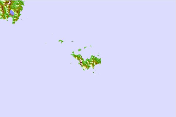
Usa este mapa para navegar hacia las playas de surf de Saint Barthélemy y estaciones de marea cercanas de The Ledge
Spots de Surf más cercanos a The Ledge:
(Clica la ubicación para más detalles)- Closest spot0 mi
- Second closest spot1 mi
- Third closest spot1 mi
- Fourth closest spot1 mi
- Fifth closest spot1 mi
Boyas marinas más cercanas a The Ledge:
- Closest Boya Marinas107 mi
- Second closest Boya Marinas129 mi
- Third closest Boya Marinas175 mi
- Fourth closest Boya Marinas218 mi
- Fifth closest Boya Marinas243 mi
Estaciones de marea más cercanas a The Ledge:
- Closest estación de mareaSaint Barthelemy1 mi
- Second closest estación de mareaDuth Cul de Sac18 mi
- Third closest estación de mareaMarigot20 mi
- Fourth closest estación de mareaBasseterre43 mi
- Fifth closest estación de mareaSaint Johns, Antigua83 mi
Airports
- The closest passenger airport to The Ledge is Gustavia/st.barthel (St.-barthelemy) Airport (SBH) in Antilles, 2 km (1 miles) away (directly).
- The second nearest airport to The Ledge is Grand Case (St. Martin) Airport (SFG), also in Antilles, 31 km (19 miles) away.
- Third is Princess Juliana International (Philipsburg) Airport (SXM) in Antilles, 33 km (20 miles) away.
- Wallblake (The Valley) Airport (AXA) in Anguilla Isl. is 40 km (25 miles) away.
- F D Roosevelt (Oranjestad) Airport (EUX) in Antilles is the fifth nearest airport to The Ledge and is 49 km (30 miles) away.
- /breaks/The-Ledge/forecasts/latest


 Nearest