
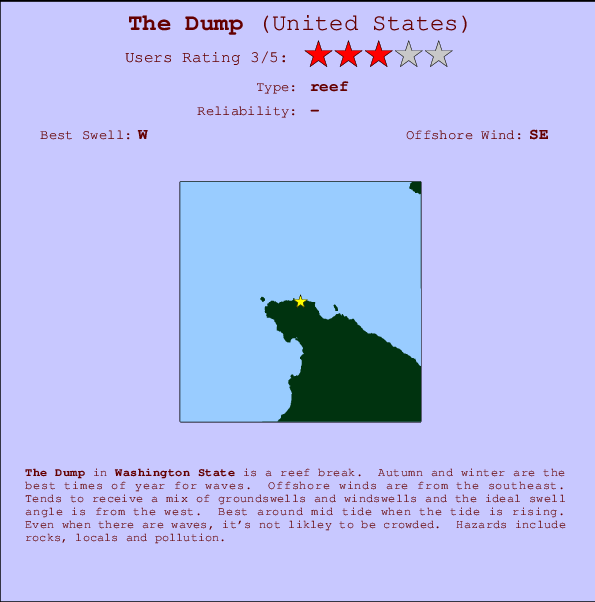
The Dump Surf Guide
The Dump in Washington State is a sheltered reef break. Autumn and winter are the best times of year for waves. The best wind direction is from the southeast. Windswells and groundswells in equal measure and the optimum swell angle is from the west. Best around mid tide when the tide is rising. Unlikely to be too crowded, even when the surf is up. Take care of rocks, locals and pollution.
The Dump Spot Info
| Type: | Rating: | Reliability: | Todays Sea Temp*: |
|---|---|---|---|
11.1°C*ocean temperature recorded from satellite |
Surfing The Dump:
The best conditions reported for surf at The Dump occur when a West swell combines with an offshore wind direction from the Southeast.
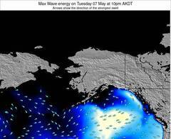
Energía de Olas (poder): 12 horas
The Dump Surf:
Tuesday, 14 July 2026, 23:54 Local time| mar | mié | |||
| 8PM | 11PM | 2AM | 5AM | |
| Wave (m) | ||||
| Período (s) | 13 | 9 | 10 | 10 |
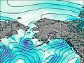
| Viento (km/h) | ||||
| Estado del Viento | cross- on |
glass | cross | cross |
- /breaks/The-Dump/forecasts/latest
The Dump Surf Guide
The Dump in Washington State is a sheltered reef break. Autumn and winter are the best times of year for waves. The best wind direction is from the southeast. Windswells and groundswells in equal measure and the optimum swell angle is from the west. Best around mid tide when the tide is rising. Unlikely to be too crowded, even when the surf is up. Take care of rocks, locals and pollution.
The Dump Spot Info
Type: Rating: Reliability: Todays Sea Temp*:  Reef
Reef 311.1°C*ocean temperature recorded from satellite
Surfing The Dump:
The best conditions reported for surf at The Dump occur when a West swell combines with an offshore wind direction from the Southeast.
Energía de Olas (poder): 12 horas
Usa la barra de navegación de arriba para ver la temperatura del mar en The Dump, fotografías The Dump, previsiones detalladas de olas para The Dump, vientos y previsión del tiempo, webcams para The Dump, viento actual desde estaciones meteorológicas en Washington y predicciones de marea para The Dump. Las mapas de olas para United States enseñarán un mapa grande de United States y los mares que rodean. Los mapas de olas pueden ser animadas para mostrar diferentes componentes de olas, la altura de ola, la energía de ola, el período, junto con previsiones de viento y del tiempo. Previsiones actuales del tiempo y del estado del mar provienen de boyas marinas de United States, del barcos que transitan en la zona y de estaciones meteorológicas costeras. Cada página de previsiones tiene un Busca-Olas Regional y Global para localizar las mejores condiciones para surfear en el área de The Dump.
The Dump Surf:
Tuesday, 14 July 2026, 23:54 Local timemar mié 8PM 11PM 2AM 5AM Wave (m) Período (s) 13 9 10 10 Viento (km/h) Estado del Viento cross-
onglass cross cross - /breaks/The-Dump/forecasts/latest
- /breaks/The-Dump/forecasts/latest/six_day
The Dump Surf Guide
The Dump in Washington State is a sheltered reef break. Autumn and winter are the best times of year for waves. The best wind direction is from the southeast. Windswells and groundswells in equal measure and the optimum swell angle is from the west. Best around mid tide when the tide is rising. Unlikely to be too crowded, even when the surf is up. Take care of rocks, locals and pollution.
The Dump Spot Info
Type: Rating: Reliability: Todays Sea Temp*: Reef311.1°C*ocean temperature recorded from satelliteSurfing The Dump:
The best conditions reported for surf at The Dump occur when a West swell combines with an offshore wind direction from the Southeast.
Energía de Olas (poder): 12 horas
Usa la barra de navegación de arriba para ver la temperatura del mar en The Dump, fotografías The Dump, previsiones detalladas de olas para The Dump, vientos y previsión del tiempo, webcams para The Dump, viento actual desde estaciones meteorológicas en Washington y predicciones de marea para The Dump. Las mapas de olas para United States enseñarán un mapa grande de United States y los mares que rodean. Los mapas de olas pueden ser animadas para mostrar diferentes componentes de olas, la altura de ola, la energía de ola, el período, junto con previsiones de viento y del tiempo. Previsiones actuales del tiempo y del estado del mar provienen de boyas marinas de United States, del barcos que transitan en la zona y de estaciones meteorológicas costeras. Cada página de previsiones tiene un Busca-Olas Regional y Global para localizar las mejores condiciones para surfear en el área de The Dump.
The Dump Surf:
Tuesday, 14 July 2026, 23:54 Local timemar mié 8PM 11PM 2AM 5AM Wave (m) Período (s) 13 9 10 10 Viento (km/h) Estado del Viento cross-
onglass cross cross - /breaks/The-Dump/forecasts/latest
The Dump Surf Guide
The Dump in Washington State is a sheltered reef break. Autumn and winter are the best times of year for waves. The best wind direction is from the southeast. Windswells and groundswells in equal measure and the optimum swell angle is from the west. Best around mid tide when the tide is rising. Unlikely to be too crowded, even when the surf is up. Take care of rocks, locals and pollution.
The Dump Spot Info
Type: Rating: Reliability: Todays Sea Temp*: Reef311.1°C*ocean temperature recorded from satelliteSurfing The Dump:
The best conditions reported for surf at The Dump occur when a West swell combines with an offshore wind direction from the Southeast.
Energía de Olas (poder): 12 horas
Usa la barra de navegación de arriba para ver la temperatura del mar en The Dump, fotografías The Dump, previsiones detalladas de olas para The Dump, vientos y previsión del tiempo, webcams para The Dump, viento actual desde estaciones meteorológicas en Washington y predicciones de marea para The Dump. Las mapas de olas para United States enseñarán un mapa grande de United States y los mares que rodean. Los mapas de olas pueden ser animadas para mostrar diferentes componentes de olas, la altura de ola, la energía de ola, el período, junto con previsiones de viento y del tiempo. Previsiones actuales del tiempo y del estado del mar provienen de boyas marinas de United States, del barcos que transitan en la zona y de estaciones meteorológicas costeras. Cada página de previsiones tiene un Busca-Olas Regional y Global para localizar las mejores condiciones para surfear en el área de The Dump.
The Dump Surf:
Tuesday, 14 July 2026, 23:54 Local timemar mié 8PM 11PM 2AM 5AM Wave (m) Período (s) 13 9 10 10 Viento (km/h) Estado del Viento cross-
onglass cross cross Tide Times:
Para Neah Bay, Washington, a %{dist} %{km} de %{location}.
PROXIMA ES A LAS (hora local) quedan marea alta marea baja The Dump Tide Times and Tide Chart
Live Weather:
At BUOY-NEAW1, 5 km from The Dump.
- Air temperature
-°CBuoy Data:
At Neah Bay Buoy, 7 miles from The Dump.
6PM 7PM 8PM 9PM Antigüedad de datos 4 hr 3 hr 2 hr 1 hr Altura de Olas (m) 


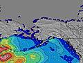
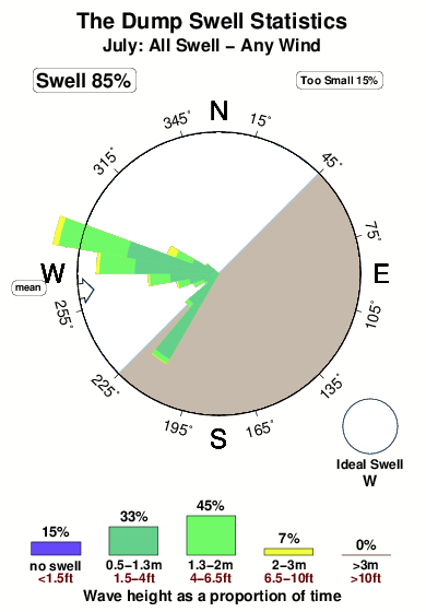
Período Dominante (s) 8 9 9 14 Overall The Dump Surf Consistency and Wind Distribution in julio
Fotos de Surf
de la galeríaContornos: Carreteras y Ríos: Selecciona un spot desde el menú 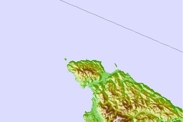
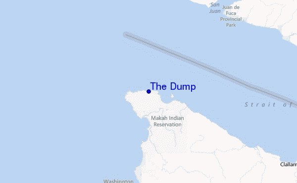
Usa este mapa para navegar hacia las playas de surf de Washington y estaciones de marea cercanas de The Dump
Spots de Surf más cercanos a The Dump:
(Clica la ubicación para más detalles)- Closest spot2 mi
- Second closest spot5 mi
- Third closest spot10 mi
- Fourth closest spot14 mi
- Fifth closest spot21 mi
Boyas marinas más cercanas a The Dump:
- Closest Boya Marinas7 mi
- Second closest Boya Marinas68 mi
- Third closest Boya Marinas69 mi
- Fourth closest Boya Marinas72 mi
- Fifth closest Boya Marinas78 mi
Estaciones de marea más cercanas a The Dump:
- Closest estación de mareaNeah Bay2 mi
- Second closest estación de mareaTatoosh Island, Cape Flattery, Strait of Juan de Fuca3 mi
- Third closest estación de mareaMakah Bay6 mi
- Fourth closest estación de mareaCape Alava16 mi
- Fifth closest estación de mareaPort Renfrew16 mi
Airports
- The closest passenger airport to The Dump is Nanaimo Airport (YCD) in Canada, 94 km (58 miles) away (directly).
- The second nearest airport to The Dump is Victoria International Airport (YYJ), also in Canada, 96 km (60 miles) away.
- Third is Port Angeles Cgas Airport (NOW) in USA, 97 km (60 miles) away.
- Tofino Airport (YAZ) in Canada is 112 km (70 miles) away.
- Vancouver International Airport (YVR), also in Canada is the fifth nearest airport to The Dump and is 141 km (88 miles) away.
- /breaks/The-Dump/forecasts/latest


 Nearest