
Previsiones:

Pronóstico Corto PlazoMayormente seco. Warm (max 20°C el martes por la tarde, min 12°C el domingo por la noche). El viento será generalmente ligero. | ||||||||||||||||||||
dom 2 | lunes 3 | martes 4 | ||||||||||||||||||
2 PM | 5 PM | 8 PM | 11 PM | 2 AM | 5 AM | 8 AM | 11 AM | 2 PM | 5 PM | 8 PM | 11 PM | 2 AM | 5 AM | 8 AM | 11 AM | 2 PM | 5 PM | 8 PM | 11 PM | |
Mapa de Altura de Olas |  | 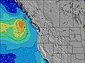 | 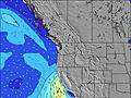 | 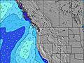 | 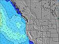 | 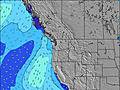 | 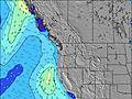 | 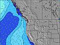 | ||||||||||||
Oleaje Altura (m) Dirección Período (s) | W 9 | W 9 | W 8 | WNW 8 | W 8 | WNW 8 | WNW 7 | WNW 7 | WNW 7 | WNW 7 | WNW 7 | WNW 7 | WNW 7 | WNW 7 | WNW 7 | WNW 7 | WNW 7 | WNW 7 | WNW 8 | WNW 8 |
Gráfico Olas | ||||||||||||||||||||
399 | 402 | 331 | 270 | 223 | 196 | 186 | 186 | 151 | 132 | 154 | 145 | 145 | 93 | 124 | 158 | 153 | 131 | 236 | 232 | |
Viento (km/h) | ||||||||||||||||||||
Estado del Viento Viento de Mar Viento de Mar-Cruzado Cruzado Viento de Tierra-Cruzado Viento de Tierra Cristalino | cross-on | cross-on | cross-on | cross | cross | glassy | glassy | cross-on | cross-on | cross-on | cross-on | cross | cross | glassy | glassy | on | cross-on | cross-on | cross-on | cross |
Marea alta | 3:47PM3.04m | 3:39AM2.78m | 4:18PM3.10m | 4:30AM2.58m | 4:54PM3.14m | |||||||||||||||
Marea baja | 9:51PM1.15m | 9:50AM0.84m | 10:39PM1.06m | 10:23AM1.05m | ||||||||||||||||
— | — | — | — | — | 5:56 | — | — | — | — | — | — | — | 5:58 | — | — | — | — | — | — | |
— | — | 8:50 | — | — | — | — | — | — | — | 8:47 | — | — | — | — | — | — | — | 8:46 | — | |
mm | — | — | — | — | — | — | — | — | — | — | — | — | — | — | — | — | — | — | — | — |
Temp. °C | 15 | 15 | 14 | 13 | 12 | 13 | 13 | 16 | 17 | 17 | 16 | 16 | 15 | 14 | 15 | 19 | 20 | 20 | 17 | 17 |
Enfriamiento °C | 11 | 10 | 10 | 10 | 10 | 12 | 12 | 15 | 15 | 14 | 12 | 13 | 14 | 13 | 15 | 18 | 17 | 17 | 14 | 15 |
Oleaje 1 Altura (m) Dirección Período (s) | W 9 | SW 13 | SW 13 | WNW 8 | W 8 | WNW 8 | WNW 7 | WNW 7 | WNW 7 | SW 13 | SW 13 | SW 13 | WNW 7 | WNW 7 | WNW 7 | WNW 7 | WNW 7 | W 9 | SW 16 | WNW 8 |
399 | 63 | 63 | 270 | 223 | 196 | 186 | 186 | 151 | 27 | 27 | 27 | 102 | 93 | 124 | 158 | 153 | 42 | 64 | 232 | |
Oleaje 2 Altura (m) Dirección Período (s) | SW 14 | SW 19 | SW 19 | SW 13 | SW 13 | SW 13 | SW 13 | SW 13 | SW 13 | WSW 18 | WSW 17 | WSW 16 | WSW 16 | WSW 16 | WSW 16 | WSW 16 | WNW 10 | WSW 16 | SW 12 | SW 16 |
65 | 14 | 14 | 63 | 63 | 62 | 45 | 45 | 27 | 30 | 29 | 26 | 51 | 51 | 51 | 51 | 31 | 50 | 6 | 62 | |
Oleaje 3 Altura (m) Dirección Período (s) | SW 19 | — | — | WSW 18 | WSW 18 | WSW 18 | WSW 18 | WSW 18 | WSW 18 | WSW 18 | — | — | SW 13 | SW 13 | SW 13 | SW 13 | WSW 16 | WSW 12 | — | SW 12 |
15 | — | — | 31 | 31 | 61 | 61 | 31 | 30 | 30 | — | — | 26 | 26 | 26 | 26 | 51 | 15 | — | 6 | |
Olas de Viento Altura (m) Dirección Período (s) | — | W 9 | W 8 | — | — | — | — | — | — | WNW 7 | WNW 7 | WNW 7 | WNW 7 | — | — | — | — | WNW 7 | WNW 8 | — |
— | 402 | 331 | — | — | — | — | — | — | 132 | 154 | 145 | 145 | — | — | — | — | 131 | 236 | — | |
Viento del Tierra o Mar Limpio más proximo | ||||||||||||||||||||
Distancia (km) | 1070 | 1498 | 1070 | 84 | 10 | 0 | 0 | 54 | 10 | 110 | 713 | 100 | 10 | 0 | 0 | 55 | 10 | 110 | 98 | 98 |
Mejores Olas Previstas en Washington State | ||||||||||||||||||||
Mejores Olas Previstas en United States | ||||||||||||||||||||
Busca-Olas Global | ||||||||||||||||||||
- Map Icons:
 Break
Break Live Wave Height (m)
 Live Wind Speed (km/h)
 Surf Rating (10 Max)
 Ocean Swells (m)
- Wind Speed (km/h)
GRÁTIS! Un widget de Surf-Forecast.com para tu sitio
Este widget grátis de previsiones de surf y tiempo puede ser añadido a cualquier otro sitio y da un resumen de previsiones de olas para The Cape. Solo necesita cortar y pegar el código HTML de abajo en su web. Puede elegir preferencias de idioma y de unidades (métricas o imperiales) para convenir a los usuarios de su sitio. Clica aquí para obtener el código.
 Nearest