

Tanjung A'an Surf Guide
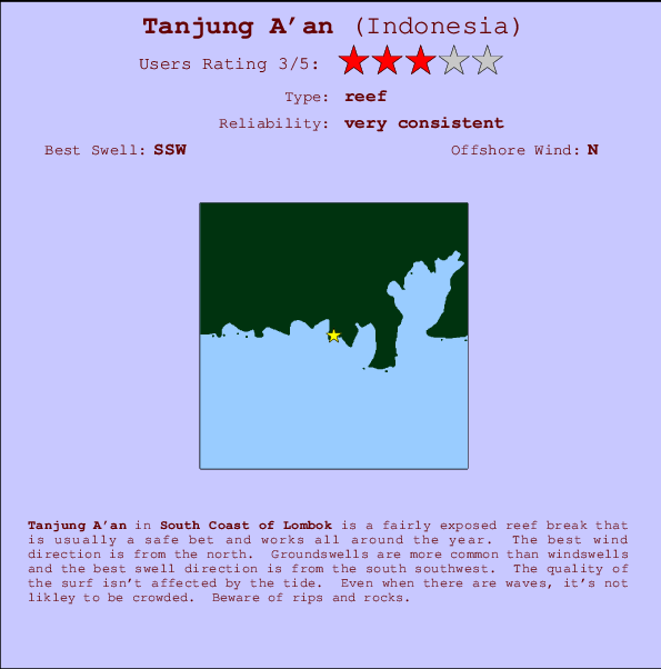
Tanjung A'an in South Lombok is a fairly exposed reef break that has very consistent surf and works all around the year. Offshore winds are from the north. Most of the surf here comes from groundswells and the best swell direction is from the south southwest. A right hand reef. The quality of the surf isn't affected by the tide. Even when there are waves, it's not likley to be crowded. Hazards include rips and rocks.
Tanjung A'an Spot Info
| Type: | Rating: | Reliability: | Todays Sea Temp*: |
|---|---|---|---|
| very consistent | 26.2°C*ocean temperature recorded from satellite |
Surfing Tanjung A'an:
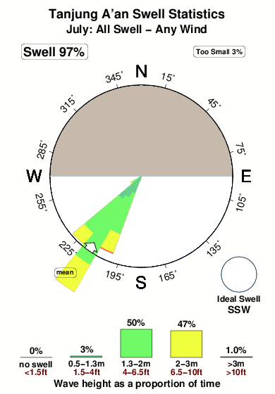
The best conditions reported for surf at Tanjung A'an occur when a South-southwest swell combines with an offshore wind direction from the North.

Energía de Olas (poder): 12 horas


Tanjung A'an Surf:
Friday, 31 July 2026, 17:45 Local time| viernes 31 | sáb | |||
| 5PM | 8PM | 11PM | 2AM | |
| Wave (m) | ||||
| Período (s) | 17 | 17 | 16 | 16 |
| Viento (km/h) | ||||
| Estado del Viento | cross- on |
cross- on |
cross- on |
cross- on |
- /breaks/Tanjung-Aan/forecasts/latest
Tanjung A'an Surf Guide
Tanjung A'an in South Lombok is a fairly exposed reef break that has very consistent surf and works all around the year. Offshore winds are from the north. Most of the surf here comes from groundswells and the best swell direction is from the south southwest. A right hand reef. The quality of the surf isn't affected by the tide. Even when there are waves, it's not likley to be crowded. Hazards include rips and rocks.
Tanjung A'an Spot Info
Type: Rating: Reliability: Todays Sea Temp*:  Reef
Reef 3
3very consistent 26.2°C*ocean temperature recorded from satelliteSurfing Tanjung A'an:
The best conditions reported for surf at Tanjung A'an occur when a South-southwest swell combines with an offshore wind direction from the North.
Energía de Olas (poder): 12 horas
Usa la barra de navegación de arriba para ver la temperatura del mar en Tanjung A'an, fotografías Tanjung A'an, previsiones detalladas de olas para Tanjung A'an, vientos y previsión del tiempo, webcams para Tanjung A'an, viento actual desde estaciones meteorológicas en Lombok - South y predicciones de marea para Tanjung A'an. Las mapas de olas para Indonesia enseñarán un mapa grande de Indonesia y los mares que rodean. Los mapas de olas pueden ser animadas para mostrar diferentes componentes de olas, la altura de ola, la energía de ola, el período, junto con previsiones de viento y del tiempo. Previsiones actuales del tiempo y del estado del mar provienen de boyas marinas de Indonesia, del barcos que transitan en la zona y de estaciones meteorológicas costeras. Cada página de previsiones tiene un Busca-Olas Regional y Global para localizar las mejores condiciones para surfear en el área de Tanjung A'an.
Tanjung A'an Surf:
Friday, 31 July 2026, 17:45 Local timeviernes 31 sáb 5PM 8PM 11PM 2AM Wave (m) Período (s) 17 17 16 16 Viento (km/h) Estado del Viento cross-
oncross-
oncross-
oncross-
on- /breaks/Tanjung-Aan/forecasts/latest
- /breaks/Tanjung-Aan/forecasts/latest/six_day
Tanjung A'an Surf Guide
Tanjung A'an in South Lombok is a fairly exposed reef break that has very consistent surf and works all around the year. Offshore winds are from the north. Most of the surf here comes from groundswells and the best swell direction is from the south southwest. A right hand reef. The quality of the surf isn't affected by the tide. Even when there are waves, it's not likley to be crowded. Hazards include rips and rocks.
Tanjung A'an Spot Info
Type: Rating: Reliability: Todays Sea Temp*: Reef3very consistent 26.2°C*ocean temperature recorded from satelliteSurfing Tanjung A'an:
The best conditions reported for surf at Tanjung A'an occur when a South-southwest swell combines with an offshore wind direction from the North.
Energía de Olas (poder): 12 horas
Usa la barra de navegación de arriba para ver la temperatura del mar en Tanjung A'an, fotografías Tanjung A'an, previsiones detalladas de olas para Tanjung A'an, vientos y previsión del tiempo, webcams para Tanjung A'an, viento actual desde estaciones meteorológicas en Lombok - South y predicciones de marea para Tanjung A'an. Las mapas de olas para Indonesia enseñarán un mapa grande de Indonesia y los mares que rodean. Los mapas de olas pueden ser animadas para mostrar diferentes componentes de olas, la altura de ola, la energía de ola, el período, junto con previsiones de viento y del tiempo. Previsiones actuales del tiempo y del estado del mar provienen de boyas marinas de Indonesia, del barcos que transitan en la zona y de estaciones meteorológicas costeras. Cada página de previsiones tiene un Busca-Olas Regional y Global para localizar las mejores condiciones para surfear en el área de Tanjung A'an.
Tanjung A'an Surf:
Friday, 31 July 2026, 17:45 Local timeviernes 31 sáb 5PM 8PM 11PM 2AM Wave (m) Período (s) 17 17 16 16 Viento (km/h) Estado del Viento cross-
oncross-
oncross-
oncross-
on- /breaks/Tanjung-Aan/forecasts/latest
Tanjung A'an Surf Guide
Tanjung A'an in South Lombok is a fairly exposed reef break that has very consistent surf and works all around the year. Offshore winds are from the north. Most of the surf here comes from groundswells and the best swell direction is from the south southwest. A right hand reef. The quality of the surf isn't affected by the tide. Even when there are waves, it's not likley to be crowded. Hazards include rips and rocks.
Tanjung A'an Spot Info
Type: Rating: Reliability: Todays Sea Temp*: Reef3very consistent 26.2°C*ocean temperature recorded from satelliteSurfing Tanjung A'an:
The best conditions reported for surf at Tanjung A'an occur when a South-southwest swell combines with an offshore wind direction from the North.
Energía de Olas (poder): 12 horas
Usa la barra de navegación de arriba para ver la temperatura del mar en Tanjung A'an, fotografías Tanjung A'an, previsiones detalladas de olas para Tanjung A'an, vientos y previsión del tiempo, webcams para Tanjung A'an, viento actual desde estaciones meteorológicas en Lombok - South y predicciones de marea para Tanjung A'an. Las mapas de olas para Indonesia enseñarán un mapa grande de Indonesia y los mares que rodean. Los mapas de olas pueden ser animadas para mostrar diferentes componentes de olas, la altura de ola, la energía de ola, el período, junto con previsiones de viento y del tiempo. Previsiones actuales del tiempo y del estado del mar provienen de boyas marinas de Indonesia, del barcos que transitan en la zona y de estaciones meteorológicas costeras. Cada página de previsiones tiene un Busca-Olas Regional y Global para localizar las mejores condiciones para surfear en el área de Tanjung A'an.
Tanjung A'an Surf:
Friday, 31 July 2026, 17:45 Local timeviernes 31 sáb 5PM 8PM 11PM 2AM Wave (m) Período (s) 17 17 16 16 Viento (km/h) Estado del Viento cross-
oncross-
oncross-
oncross-
onTide Times:
Para Aan, a %{dist} %{km} de %{location}.
PROXIMA ES A LAS (hora local) quedan marea alta marea baja Tanjung A'an Tide Times and Tide Chart
Live Weather:
At Bandara Airport, 20 km from Tanjung A'an.
light winds from the SE.(Wind varies from 100 to 160 degs)
(km/h)Air temperature
28°COverall Tanjung A'an Surf Consistency and Wind Distribution in julio
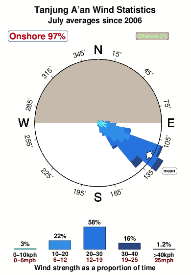


Wind stats for Tanjung A'an: see the variation in direction and stength by month.
Fotos de Surf
de la galeríaContornos: Carreteras y Ríos: Selecciona un spot desde el menú 


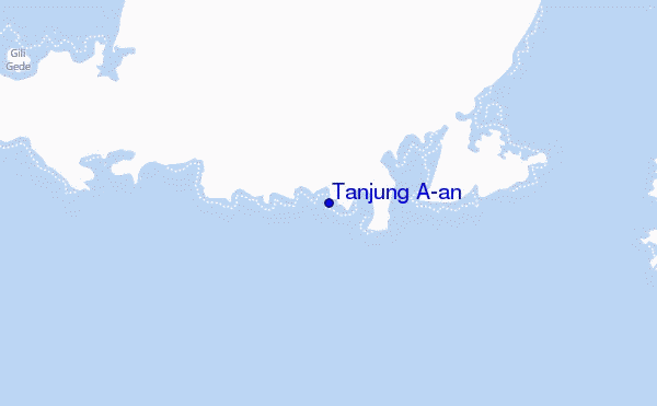
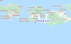
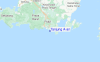
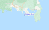
Usa este mapa para navegar hacia las playas de surf de Lombok - South y estaciones de marea cercanas de Tanjung A'an
Spots de Surf más cercanos a Tanjung A'an:
(Clica la ubicación para más detalles)- Closest spot2 mi
- Second closest spot2 mi
- Third closest spot2 mi
- Fourth closest spot2 mi
- Fifth closest spot3 mi
Boyas marinas más cercanas a Tanjung A'an:
- Closest Boya Marinas1740 mi
- Second closest Boya Marinas2050 mi
- Third closest Boya Marinas2175 mi
- Fourth closest Boya Marinas2253 mi
- Fifth closest Boya Marinas2270 mi
Estaciones de marea más cercanas a Tanjung A'an:
- Closest estación de mareaMataram27 mi
- Second closest estación de mareaDenpasar78 mi
- Third closest estación de mareaSumbawa Besar81 mi
- Fourth closest estación de mareaSingaraja101 mi
- Fifth closest estación de mareaBanjar106 mi
Airports
- The closest passenger airport to Tanjung A'an is Selaparang (Mataram) Airport (AMI) in Indonesia, which is 48 km (30 miles) away (directly).
- The second nearest airport to Tanjung A'an is Bali International (Denpasar) Airport (DPS), also in Indonesia, 129 km (80 miles) away.
- The third closest airport is Sumbawa Besar Airport (SWG), also in Indonesia, 129 km (80 miles) away.
- /breaks/Tanjung-Aan/forecasts/latest
 Nearest