
Previsiones:

Pronóstico Corto PlazoAlgo de llovizna, más pesada durante la noche de miércoles. Warm (max 32°C el martes por la mañana, min 27°C el lunes por la noche). El viento será generalmente ligero. | ||||||||||||||||||||||||
lun 13 | martes 14 | miércoles 15 | jue 16 | |||||||||||||||||||||
12 PM | 3 PM | 6 PM | 9 PM | 12 AM | 3 AM | 6 AM | 9 AM | 12 PM | 3 PM | 6 PM | 9 PM | 12 AM | 3 AM | 6 AM | 9 AM | 12 PM | 3 PM | 6 PM | 9 PM | 12 AM | 3 AM | 6 AM | 9 AM | |
Mapa de Altura de Olas |  |  |  | 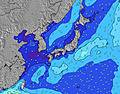 |  |  | 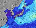 |  |  | 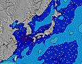 | ||||||||||||||
Oleaje Altura (m) Dirección Período (s) | SSW 11 | SSW 11 | SSW 11 | SSW 11 | SSW 11 | SSW 10 | SSW 10 | SSW 10 | SSW 10 | SSW 10 | SSW 9 | SSW 9 | SSW 9 | SSW 9 | SSW 9 | SSW 9 | SSW 9 | SSW 9 | SSW 8 | SSW 8 | SSW 8 | SSW 7 | SSW 8 | SSW 8 |
Gráfico Olas | ||||||||||||||||||||||||
540 | 447 | 415 | 356 | 292 | 265 | 214 | 209 | 173 | 157 | 118 | 113 | 86 | 86 | 84 | 84 | 62 | 67 | 78 | 76 | 75 | 38 | 100 | 95 | |
Viento (km/h) | ||||||||||||||||||||||||
Estado del Viento Viento de Mar Viento de Mar-Cruzado Cruzado Viento de Tierra-Cruzado Viento de Tierra Cristalino | cross-on | cross-on | cross | glassy | off | off | off | cross-off | cross | on | cross-on | cross | cross | glassy | glassy | cross | cross-on | cross-on | glassy | glassy | glassy | glassy | cross-off | glassy |
Marea alta | 6:04PM1.79m | 4:46AM1.83m | 6:38PM1.84m | 5:30AM1.88m | 7:09PM1.86m | 6:12AM1.90m | ||||||||||||||||||
Marea baja | 11:04AM0.18m | 11:23PM1.09m | 11:44AM0.12m | 00:01AM1.02m | 12:22PM0.11m | 00:38AM0.95m | ||||||||||||||||||
— | — | — | — | — | 5:00 | — | — | — | — | — | — | — | 5:01 | — | — | — | — | — | — | — | 5:01 | — | — | |
— | — | 7:14 | — | — | — | — | — | — | — | 7:13 | — | — | — | — | — | — | — | 7:13 | — | — | — | — | 7:12 | |
mm | — | — | — | — | — | — | — | — | — | — | — | — | — | — | — | — | — | — | — | — | 1 | — | — | — |
Temp. °C | 30 | 31 | 30 | 29 | 28 | 27 | 27 | 30 | 32 | 30 | 30 | 28 | 28 | 27 | 27 | 29 | 30 | 29 | 29 | 28 | 27 | 27 | 27 | 29 |
Enfriamiento °C | 34 | 36 | 34 | 34 | 32 | 30 | 31 | 34 | 36 | 34 | 35 | 33 | 33 | 33 | 33 | 33 | 34 | 34 | 35 | 34 | 33 | 33 | 32 | 34 |
Oleaje 1 Altura (m) Dirección Período (s) | SSW 11 | SSW 11 | SSW 11 | SSW 11 | SSW 11 | SSW 10 | SSW 10 | SSW 10 | SSW 10 | SSW 10 | SSW 9 | SSW 9 | SSW 9 | SSW 9 | SSW 9 | SSW 9 | SSW 9 | SSW 9 | SSW 8 | SSW 8 | SSW 8 | SSW 7 | SSW 8 | SSW 8 |
540 | 447 | 415 | 356 | 292 | 265 | 214 | 209 | 173 | 157 | 118 | 113 | 86 | 86 | 84 | 84 | 62 | 67 | 78 | 76 | 75 | 38 | 100 | 95 | |
Oleaje 2 Altura (m) Dirección Período (s) | SE 10 | SE 10 | SE 10 | SE 11 | SE 10 | SE 10 | SE 10 | ESE 10 | SE 12 | SE 12 | SE 12 | SE 12 | SE 11 | SE 11 | SE 11 | SE 11 | SE 10 | SE 10 | SE 10 | ESE 10 | SE 10 | SSW 8 | SE 11 | SE 10 |
17 | 17 | 17 | 29 | 24 | 15 | 14 | 9 | 22 | 36 | 36 | 35 | 31 | 30 | 29 | 29 | 28 | 28 | 27 | 40 | 17 | 37 | 18 | 14 | |
Oleaje 3 Altura (m) Dirección Período (s) | SE 13 | E 9 | SE 13 | E 9 | SE 12 | SE 12 | SE 12 | SE 12 | ENE 9 | — | E 9 | SE 12 | E 9 | E 10 | SE 11 | E 10 | — | S 8 | S 8 | SE 10 | ESE 9 | SE 11 | ESE 10 | ESE 10 |
7 | 6 | 7 | 2 | 6 | 6 | 23 | 23 | 8 | — | 2 | 22 | 15 | 19 | 18 | 16 | — | 1 | 1 | 17 | 16 | 18 | 19 | 19 | |
Olas de Viento Altura (m) Dirección Período (s) | — | — | — | — | — | — | — | NNE 3 | NNE 3 | NNE 3 | — | — | — | — | — | — | — | — | — | SW 7 | — | — | — | — |
— | — | — | — | — | — | — | 3 | 3 | 2 | — | — | — | — | — | — | — | — | — | 55 | — | — | — | — | |
Viento del Tierra o Mar Limpio más proximo | ||||||||||||||||||||||||
Distancia (km) | 19 | 3 | 3 | 0 | 0 | 0 | 0 | 0 | 51 | 2 | 3 | 2 | 2 | 0 | 0 | 21 | 51 | 3 | 0 | 0 | 0 | 0 | 0 | 0 |
Mejores Olas Previstas en Shikoku | ||||||||||||||||||||||||
Mejores Olas Previstas en Japan | ||||||||||||||||||||||||
Busca-Olas Global | ||||||||||||||||||||||||
- Map Icons:
 Break
Break Live Wave Height (m)
 Live Wind Speed (km/h)
 Surf Rating (10 Max)
 Ocean Swells (m)
- Wind Speed (km/h)
GRÁTIS! Un widget de Surf-Forecast.com para tu sitio
Este widget grátis de previsiones de surf y tiempo puede ser añadido a cualquier otro sitio y da un resumen de previsiones de olas para Tainohama. Solo necesita cortar y pegar el código HTML de abajo en su web. Puede elegir preferencias de idioma y de unidades (métricas o imperiales) para convenir a los usuarios de su sitio. Clica aquí para obtener el código.
 Nearest