
Previsiones:

Pronóstico Corto PlazoMayormente seco. Very mild (max 18°C el martes por la mañana, min 11°C el miércoles por la noche). El viento será generalmente ligero. | ||||||||||||||||||||
lun 27 | martes 28 | miércoles 29 | ||||||||||||||||||
2 PM | 5 PM | 8 PM | 11 PM | 2 AM | 5 AM | 8 AM | 11 AM | 2 PM | 5 PM | 8 PM | 11 PM | 2 AM | 5 AM | 8 AM | 11 AM | 2 PM | 5 PM | 8 PM | 11 PM | |
Mapa de Altura de Olas |  |  | 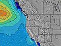 | 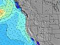 |  |  | 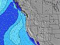 | 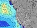 | ||||||||||||
Oleaje Altura (m) Dirección Período (s) | SW 18 | SW 18 | SW 18 | SW 18 | SW 18 | SW 19 | SW 19 | SW 16 | SW 16 | SW 16 | SW 17 | SW 17 | SW 17 | SW 17 | SW 17 | SW 17 | SW 17 | SW 16 | SW 16 | SW 16 |
Gráfico Olas | ||||||||||||||||||||
522 | 522 | 375 | 447 | 546 | 595 | 372 | 254 | 206 | 322 | 334 | 413 | 423 | 423 | 499 | 418 | 346 | 260 | 310 | 310 | |
Viento (km/h) | ||||||||||||||||||||
Estado del Viento Viento de Mar Viento de Mar-Cruzado Cruzado Viento de Tierra-Cruzado Viento de Tierra Cristalino | on | on | glassy | cross-off | cross-off | cross-off | cross-off | cross-on | on | cross-on | cross | cross-off | cross-off | cross-off | cross-off | cross-on | cross-on | cross-on | cross | cross |
Marea alta | 1:10PM1.49m | 11:38PM1.98m | 1:39PM1.53m | 00:18AM2.00m | 2:07PM1.58m | |||||||||||||||
Marea baja | 6:12PM0.79m | 7:18AM-0.12m | 6:53PM0.73m | 7:51AM-0.16m | 7:32PM0.67m | |||||||||||||||
— | — | — | — | — | 5:56 | — | — | — | — | — | — | — | 5:56 | — | — | — | — | — | — | |
— | — | 8:47 | — | — | — | — | — | — | — | 8:46 | — | — | — | — | — | — | — | 8:45 | — | |
mm | — | — | — | — | — | — | — | — | — | — | — | — | — | — | — | — | — | — | — | — |
Temp. °C | 17 | 17 | 16 | 14 | 14 | 15 | 16 | 18 | 18 | 18 | 16 | 13 | 12 | 12 | 13 | 17 | 17 | 16 | 14 | 12 |
Enfriamiento °C | 16 | 16 | 17 | 14 | 14 | 15 | 16 | 17 | 17 | 17 | 16 | 12 | 11 | 11 | 12 | 15 | 14 | 13 | 12 | 11 |
Oleaje 1 Altura (m) Dirección Período (s) | SW 18 | SW 18 | SW 18 | SW 18 | WNW 9 | WNW 8 | W 8 | W 8 | W 8 | W 8 | WNW 8 | WNW 8 | WNW 8 | WNW 9 | WNW 9 | WNW 9 | WNW 9 | WNW 8 | WNW 8 | WNW 8 |
522 | 522 | 375 | 447 | 106 | 120 | 113 | 111 | 137 | 161 | 159 | 155 | 197 | 232 | 238 | 249 | 197 | 184 | 151 | 207 | |
Oleaje 2 Altura (m) Dirección Período (s) | NW 9 | NW 9 | NW 9 | NW 9 | SW 18 | SW 19 | SW 19 | SW 16 | SW 16 | SW 16 | SW 17 | SW 17 | SW 17 | SW 17 | SW 17 | SW 17 | SW 17 | SW 16 | SW 16 | SW 16 |
97 | 95 | 95 | 91 | 546 | 595 | 372 | 254 | 206 | 322 | 334 | 413 | 423 | 423 | 499 | 418 | 346 | 260 | 310 | 310 | |
Oleaje 3 Altura (m) Dirección Período (s) | WSW 5 | WSW 5 | WSW 5 | WSW 5 | SSW 11 | SSW 11 | SW 16 | SW 19 | SW 19 | SW 12 | SW 12 | SW 12 | SW 12 | SSW 11 | — | — | SW 12 | SW 12 | SSW 11 | SSW 11 |
17 | 11 | 9 | 11 | 12 | 12 | 155 | 183 | 177 | 36 | 35 | 36 | 38 | 11 | — | — | 37 | 35 | 24 | 24 | |
Olas de Viento Altura (m) Dirección Período (s) | — | — | — | — | — | — | — | — | — | — | — | — | — | — | — | — | NNW 3 | NNW 4 | NNW 4 | — |
— | — | — | — | — | — | — | — | — | — | — | — | — | — | — | — | 8 | 13 | 14 | — | |
Viento del Tierra o Mar Limpio más proximo | ||||||||||||||||||||
Distancia (km) | 0 | 220 | 281 | 220 | 0 | 0 | 0 | 0 | 0 | 220 | 220 | 902 | 149 | 21 | 0 | 0 | 0 | 149 | 903 | 903 |
Mejores Olas Previstas en North Oregon | ||||||||||||||||||||
Mejores Olas Previstas en United States | ||||||||||||||||||||
Busca-Olas Global | ||||||||||||||||||||
- Map Icons:
 Break
Break Live Wave Height (m)
 Live Wind Speed (km/h)
 Surf Rating (10 Max)
 Ocean Swells (m)
- Wind Speed (km/h)
GRÁTIS! Un widget de Surf-Forecast.com para tu sitio
Este widget grátis de previsiones de surf y tiempo puede ser añadido a cualquier otro sitio y da un resumen de previsiones de olas para Taft (Siltetz River). Solo necesita cortar y pegar el código HTML de abajo en su web. Puede elegir preferencias de idioma y de unidades (métricas o imperiales) para convenir a los usuarios de su sitio. Clica aquí para obtener el código.
 Nearest