
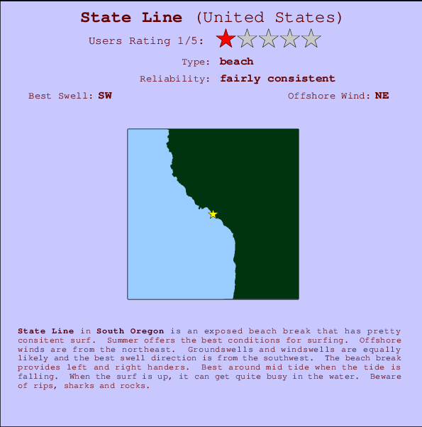
State Line Surf Guide
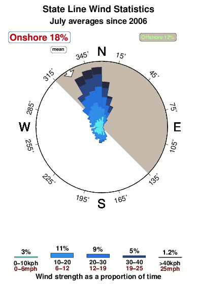
State Line in Oregon_South is an exposed beach break that has pretty consitent surf. Summer offers the best conditions for surfing. Offshore winds blow from the northeast. Most of the surf here comes from groundswells and the best swell direction is from the southwest. The beach breaks offer lefts and rights. Best around mid tide. When it's working here, it can get crowded. Beware of rips, sharks and rocks.
State Line Spot Info
| Type: | Rating: | Reliability: | Todays Sea Temp*: |
|---|---|---|---|
| fairly consistent | 12.1°C*ocean temperature recorded from satellite |
Surfing State Line:
The best conditions reported for surf at State Line occur when a Southwest swell combines with an offshore wind direction from the Northeast.
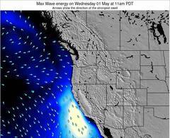
Energía de Olas (poder): 12 horas

State Line Surf:
Thursday, 23 July 2026, 17:42 Local time| jueves 23 | ||||
| 2PM | 5PM | 8PM | 11PM | |
| Wave (m) | ||||
| Período (s) | 14 | 14 | 14 | 14 |
| Viento (km/h) | ||||
| Estado del Viento | on | on | glass | glass |
- /breaks/State-Line/forecasts/latest
State Line Surf Guide
State Line in Oregon_South is an exposed beach break that has pretty consitent surf. Summer offers the best conditions for surfing. Offshore winds blow from the northeast. Most of the surf here comes from groundswells and the best swell direction is from the southwest. The beach breaks offer lefts and rights. Best around mid tide. When it's working here, it can get crowded. Beware of rips, sharks and rocks.
State Line Spot Info
Type: Rating: Reliability: Todays Sea Temp*:  Beach
Beach 1
1fairly consistent 12.1°C*ocean temperature recorded from satelliteSurfing State Line:
The best conditions reported for surf at State Line occur when a Southwest swell combines with an offshore wind direction from the Northeast.
Energía de Olas (poder): 12 horas
Usa la barra de navegación de arriba para ver la temperatura del mar en State Line, fotografías State Line, previsiones detalladas de olas para State Line, vientos y previsión del tiempo, webcams para State Line, viento actual desde estaciones meteorológicas en Oregon South y predicciones de marea para State Line. Las mapas de olas para United States enseñarán un mapa grande de United States y los mares que rodean. Los mapas de olas pueden ser animadas para mostrar diferentes componentes de olas, la altura de ola, la energía de ola, el período, junto con previsiones de viento y del tiempo. Previsiones actuales del tiempo y del estado del mar provienen de boyas marinas de United States, del barcos que transitan en la zona y de estaciones meteorológicas costeras. Cada página de previsiones tiene un Busca-Olas Regional y Global para localizar las mejores condiciones para surfear en el área de State Line.
State Line Surf:
Thursday, 23 July 2026, 17:42 Local timejueves 23 2PM 5PM 8PM 11PM Wave (m) Período (s) 14 14 14 14 Viento (km/h) Estado del Viento on on glass glass - /breaks/State-Line/forecasts/latest
- /breaks/State-Line/forecasts/latest/six_day
State Line Surf Guide
State Line in Oregon_South is an exposed beach break that has pretty consitent surf. Summer offers the best conditions for surfing. Offshore winds blow from the northeast. Most of the surf here comes from groundswells and the best swell direction is from the southwest. The beach breaks offer lefts and rights. Best around mid tide. When it's working here, it can get crowded. Beware of rips, sharks and rocks.
State Line Spot Info
Type: Rating: Reliability: Todays Sea Temp*: Beach1fairly consistent 12.1°C*ocean temperature recorded from satelliteSurfing State Line:
The best conditions reported for surf at State Line occur when a Southwest swell combines with an offshore wind direction from the Northeast.
Energía de Olas (poder): 12 horas
Usa la barra de navegación de arriba para ver la temperatura del mar en State Line, fotografías State Line, previsiones detalladas de olas para State Line, vientos y previsión del tiempo, webcams para State Line, viento actual desde estaciones meteorológicas en Oregon South y predicciones de marea para State Line. Las mapas de olas para United States enseñarán un mapa grande de United States y los mares que rodean. Los mapas de olas pueden ser animadas para mostrar diferentes componentes de olas, la altura de ola, la energía de ola, el período, junto con previsiones de viento y del tiempo. Previsiones actuales del tiempo y del estado del mar provienen de boyas marinas de United States, del barcos que transitan en la zona y de estaciones meteorológicas costeras. Cada página de previsiones tiene un Busca-Olas Regional y Global para localizar las mejores condiciones para surfear en el área de State Line.
State Line Surf:
Thursday, 23 July 2026, 17:42 Local timejueves 23 2PM 5PM 8PM 11PM Wave (m) Período (s) 14 14 14 14 Viento (km/h) Estado del Viento on on glass glass - /breaks/State-Line/forecasts/latest
State Line Surf Guide
State Line in Oregon_South is an exposed beach break that has pretty consitent surf. Summer offers the best conditions for surfing. Offshore winds blow from the northeast. Most of the surf here comes from groundswells and the best swell direction is from the southwest. The beach breaks offer lefts and rights. Best around mid tide. When it's working here, it can get crowded. Beware of rips, sharks and rocks.
State Line Spot Info
Type: Rating: Reliability: Todays Sea Temp*: Beach1fairly consistent 12.1°C*ocean temperature recorded from satelliteSurfing State Line:
The best conditions reported for surf at State Line occur when a Southwest swell combines with an offshore wind direction from the Northeast.
Energía de Olas (poder): 12 horas
Usa la barra de navegación de arriba para ver la temperatura del mar en State Line, fotografías State Line, previsiones detalladas de olas para State Line, vientos y previsión del tiempo, webcams para State Line, viento actual desde estaciones meteorológicas en Oregon South y predicciones de marea para State Line. Las mapas de olas para United States enseñarán un mapa grande de United States y los mares que rodean. Los mapas de olas pueden ser animadas para mostrar diferentes componentes de olas, la altura de ola, la energía de ola, el período, junto con previsiones de viento y del tiempo. Previsiones actuales del tiempo y del estado del mar provienen de boyas marinas de United States, del barcos que transitan en la zona y de estaciones meteorológicas costeras. Cada página de previsiones tiene un Busca-Olas Regional y Global para localizar las mejores condiciones para surfear en el área de State Line.
State Line Surf:
Thursday, 23 July 2026, 17:42 Local timejueves 23 2PM 5PM 8PM 11PM Wave (m) Período (s) 14 14 14 14 Viento (km/h) Estado del Viento on on glass glass Tide Times:
Para Brookings, Chetco Cove, Oregon, a %{dist} %{km} de %{location}.
PROXIMA ES A LAS (hora local) quedan marea alta marea baja State Line Tide Times and Tide Chart
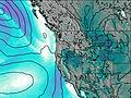
Live Weather:
At Brookings Airport (OR), 4 km from State Line.
light winds from the N
(km/h)
ClearAir temperature
18.3°CCurrent weather near State Line
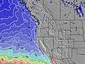
Buoy Data:
At St Georges Buoy, 14 miles from State Line.
12PM 1PM 2PM 3PM Antigüedad de datos 4 hr 3 hr 2 hr 1 hr Altura de Olas (m) 


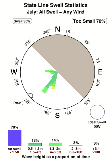
Período Dominante (s) 10 9 9 9 Overall State Line Surf Consistency and Wind Distribution in julio
Fotos de Surf
de la galeríaContornos: Carreteras y Ríos: Selecciona un spot desde el menú 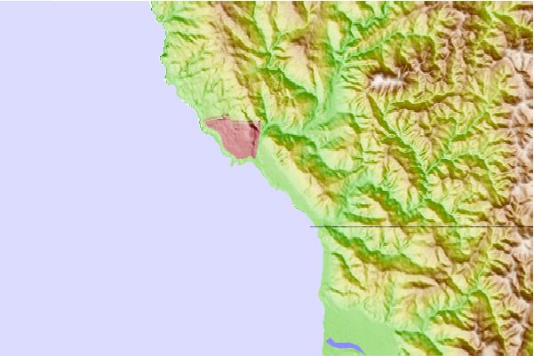
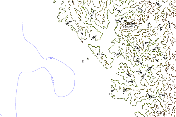
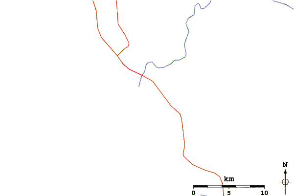
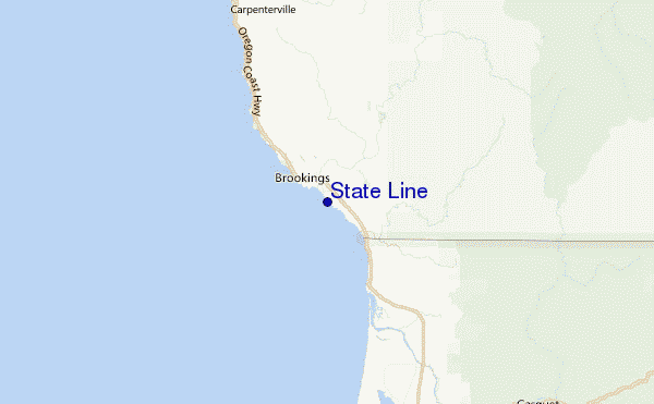
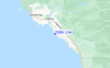
Usa este mapa para navegar hacia las playas de surf de Oregon South y estaciones de marea cercanas de State Line
Spots de Surf más cercanos a State Line:
(Clica la ubicación para más detalles)- Closest spot2 mi
- Second closest spot4 mi
- Third closest spot9 mi
- Fourth closest spot17 mi
- Fifth closest spot18 mi
Boyas marinas más cercanas a State Line:
- Closest Boya Marinas14 mi
- Second closest Boya Marinas57 mi
- Third closest Boya Marinas78 mi
- Fourth closest Boya Marinas90 mi
- Fifth closest Boya Marinas108 mi
Estaciones de marea más cercanas a State Line:
- Closest estación de mareaBrookings, Chetco Cove2 mi
- Second closest estación de mareaCrescent City21 mi
- Third closest estación de mareaWedderburn, Rogue River29 mi
- Fourth closest estación de mareaPort Orford50 mi
- Fifth closest estación de mareaTrinidad Harbor68 mi
Airports
- The nearest passenger airport to State Line is Chico Muni Airport (CIC) in USA, which is 320 km (199 miles) away (directly).
- The second closest airport to State Line is Mc Minnville Muni (Mackminnville) Airport (MMV), also in USA, 363 km (225 miles) away.
- /breaks/State-Line/forecasts/latest


 Nearest