

Shipwreck Surf Guide
Shipwreck in Liberia is an exposed reef break that is usually a safe bet and works all around the year. The best wind direction is from the northeast. Tends to receive distant groundswells and the ideal swell direction is from the southwest. Best around high tide when the tide is falling. The location means that it never gets crowded. Hazards include - Rips / undertow - Rocks.
Shipwreck Spot Info
| Type: | Rating: | Reliability: | Todays Sea Temp*: |
|---|---|---|---|
| very consistent | 27.7°C*ocean temperature recorded from satellite |
Surfing Shipwreck:
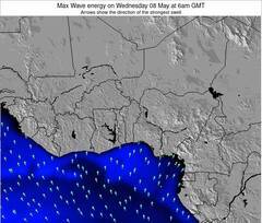
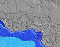
The best conditions reported for surf at Shipwreck occur when a Southwest swell combines with an offshore wind direction from the Northeast.
Energía de Olas (poder): 12 horas
Shipwreck Surf:
Wednesday, 15 July 2026, 13:21 Local time| miércoles 15 | ||||
| 9AM | 12PM | 3PM | 6PM | |
| Wave (m) | ||||
| Período (s) | 6 | 6 | 6 | 6 |
| Viento (km/h) | ||||
| Estado del Viento | cross- on |
cross- on |
cross- on |
on |
- /breaks/Robertsport/forecasts/latest
Shipwreck Surf Guide
Shipwreck in Liberia is an exposed reef break that is usually a safe bet and works all around the year. The best wind direction is from the northeast. Tends to receive distant groundswells and the ideal swell direction is from the southwest. Best around high tide when the tide is falling. The location means that it never gets crowded. Hazards include - Rips / undertow - Rocks.
Shipwreck Spot Info
Type: Rating: Reliability: Todays Sea Temp*:  Reef
Reef 3
3very consistent 27.7°C*ocean temperature recorded from satelliteSurfing Shipwreck:
The best conditions reported for surf at Shipwreck occur when a Southwest swell combines with an offshore wind direction from the Northeast.
Energía de Olas (poder): 12 horas
Usa la barra de navegación de arriba para ver la temperatura del mar en Shipwreck, fotografías Shipwreck, previsiones detalladas de olas para Shipwreck, vientos y previsión del tiempo, webcams para Shipwreck, viento actual desde estaciones meteorológicas en Liberia y predicciones de marea para Shipwreck. Las mapas de olas para Liberia enseñarán un mapa grande de Liberia y los mares que rodean. Los mapas de olas pueden ser animadas para mostrar diferentes componentes de olas, la altura de ola, la energía de ola, el período, junto con previsiones de viento y del tiempo. Previsiones actuales del tiempo y del estado del mar provienen de boyas marinas de Liberia, del barcos que transitan en la zona y de estaciones meteorológicas costeras. Cada página de previsiones tiene un Busca-Olas Regional y Global para localizar las mejores condiciones para surfear en el área de Shipwreck.
Shipwreck Surf:
Wednesday, 15 July 2026, 13:21 Local timemiércoles 15 9AM 12PM 3PM 6PM Wave (m) Período (s) 6 6 6 6 Viento (km/h) Estado del Viento cross-
oncross-
oncross-
onon - /breaks/Robertsport/forecasts/latest
- /breaks/Robertsport/forecasts/latest/six_day
Shipwreck Surf Guide
Shipwreck in Liberia is an exposed reef break that is usually a safe bet and works all around the year. The best wind direction is from the northeast. Tends to receive distant groundswells and the ideal swell direction is from the southwest. Best around high tide when the tide is falling. The location means that it never gets crowded. Hazards include - Rips / undertow - Rocks.
Shipwreck Spot Info
Type: Rating: Reliability: Todays Sea Temp*: Reef3very consistent 27.7°C*ocean temperature recorded from satelliteSurfing Shipwreck:
The best conditions reported for surf at Shipwreck occur when a Southwest swell combines with an offshore wind direction from the Northeast.
Energía de Olas (poder): 12 horas
Usa la barra de navegación de arriba para ver la temperatura del mar en Shipwreck, fotografías Shipwreck, previsiones detalladas de olas para Shipwreck, vientos y previsión del tiempo, webcams para Shipwreck, viento actual desde estaciones meteorológicas en Liberia y predicciones de marea para Shipwreck. Las mapas de olas para Liberia enseñarán un mapa grande de Liberia y los mares que rodean. Los mapas de olas pueden ser animadas para mostrar diferentes componentes de olas, la altura de ola, la energía de ola, el período, junto con previsiones de viento y del tiempo. Previsiones actuales del tiempo y del estado del mar provienen de boyas marinas de Liberia, del barcos que transitan en la zona y de estaciones meteorológicas costeras. Cada página de previsiones tiene un Busca-Olas Regional y Global para localizar las mejores condiciones para surfear en el área de Shipwreck.
Shipwreck Surf:
Wednesday, 15 July 2026, 13:21 Local timemiércoles 15 9AM 12PM 3PM 6PM Wave (m) Período (s) 6 6 6 6 Viento (km/h) Estado del Viento cross-
oncross-
oncross-
onon - /breaks/Robertsport/forecasts/latest
Shipwreck Surf Guide
Shipwreck in Liberia is an exposed reef break that is usually a safe bet and works all around the year. The best wind direction is from the northeast. Tends to receive distant groundswells and the ideal swell direction is from the southwest. Best around high tide when the tide is falling. The location means that it never gets crowded. Hazards include - Rips / undertow - Rocks.
Shipwreck Spot Info
Type: Rating: Reliability: Todays Sea Temp*: Reef3very consistent 27.7°C*ocean temperature recorded from satelliteSurfing Shipwreck:
The best conditions reported for surf at Shipwreck occur when a Southwest swell combines with an offshore wind direction from the Northeast.
Energía de Olas (poder): 12 horas
Usa la barra de navegación de arriba para ver la temperatura del mar en Shipwreck, fotografías Shipwreck, previsiones detalladas de olas para Shipwreck, vientos y previsión del tiempo, webcams para Shipwreck, viento actual desde estaciones meteorológicas en Liberia y predicciones de marea para Shipwreck. Las mapas de olas para Liberia enseñarán un mapa grande de Liberia y los mares que rodean. Los mapas de olas pueden ser animadas para mostrar diferentes componentes de olas, la altura de ola, la energía de ola, el período, junto con previsiones de viento y del tiempo. Previsiones actuales del tiempo y del estado del mar provienen de boyas marinas de Liberia, del barcos que transitan en la zona y de estaciones meteorológicas costeras. Cada página de previsiones tiene un Busca-Olas Regional y Global para localizar las mejores condiciones para surfear en el área de Shipwreck.
Shipwreck Surf:
Wednesday, 15 July 2026, 13:21 Local timemiércoles 15 9AM 12PM 3PM 6PM Wave (m) Período (s) 6 6 6 6 Viento (km/h) Estado del Viento cross-
oncross-
oncross-
onon Tide Times:
Para Robertsport, a %{dist} %{km} de %{location}.
PROXIMA ES A LAS (hora local) quedan marea alta marea baja Shipwreck Tide Times and Tide Chart
Live Weather:
At Roberts International Airport/Monrovia, 128 km from Shipwreck.
light winds from the S
(km/h)
Dry and partly cloudyAir temperature
26°COverall Shipwreck Surf Consistency and Wind Distribution in julio
Fotos de Surf
de la galeríaContornos: Carreteras y Ríos: Selecciona un spot desde el menú 


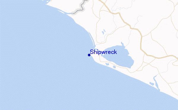
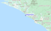
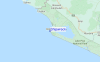
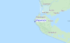
Usa este mapa para navegar hacia las playas de surf de Liberia y estaciones de marea cercanas de Shipwreck
Spots de Surf más cercanos a Shipwreck:
(Clica la ubicación para más detalles)- Closest spot1 mi
- Second closest spot1 mi
- Third closest spot1 mi
- Fourth closest spot1 mi
- Fifth closest spot21 mi
Boyas marinas más cercanas a Shipwreck:
- Closest Boya Marinas913 mi
- Second closest Boya Marinas1809 mi
- Third closest Boya Marinas1828 mi
- Fourth closest Boya Marinas2097 mi
- Fifth closest Boya Marinas2161 mi
Estaciones de marea más cercanas a Shipwreck:
- Closest estación de mareaRobertsport1 mi
- Second closest estación de mareaMonrovia, Liberia49 mi
- Third closest estación de mareaBonthe94 mi
- Fourth closest estación de mareaBuchanan109 mi
- Fifth closest estación de mareaHastings165 mi
Airports
- The nearest passenger airport to Shipwreck is Monrovia Spriggs Payne Airport (MLW) in Liberia, which is 85 km (53 miles) away (directly).
- The second closest airport to Shipwreck is Monrovia Roberts International Airport (ROB), also in Liberia, 126 km (78 miles) away.

- /breaks/Robertsport/forecasts/latest


 Nearest