
Previsiones:

Pronóstico Corto PlazoMayormente seco. Warm (max 24°C el martes por la mañana, min 11°C el domingo por la noche). El viento será generalmente ligero. | ||||||||||||||||||
dom 2 | lunes 3 | martes 4 | ||||||||||||||||
8 PM | 11 PM | 2 AM | 5 AM | 8 AM | 11 AM | 2 PM | 5 PM | 8 PM | 11 PM | 2 AM | 5 AM | 8 AM | 11 AM | 2 PM | 5 PM | 8 PM | 11 PM | |
Mapa de Altura de Olas |  |  | 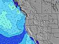 |  |  | 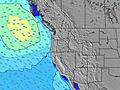 |  | |||||||||||
Oleaje Altura (m) Dirección Período (s) | WNW 9 | WNW 9 | WNW 8 | WNW 8 | NW 8 | NW 8 | NW 6 | NNW 6 | NNW 7 | NNW 7 | NNW 7 | NW 7 | NW 7 | NW 7 | NW 7 | NW 7 | NW 7 | NW 7 |
Gráfico Olas | ||||||||||||||||||
405 | 372 | 277 | 232 | 277 | 239 | 223 | 319 | 392 | 418 | 332 | 276 | 258 | 234 | 258 | 352 | 407 | 452 | |
Viento (km/h) | ||||||||||||||||||
Estado del Viento Viento de Mar Viento de Mar-Cruzado Cruzado Viento de Tierra-Cruzado Viento de Tierra Cristalino | cross | cross-off | cross-off | cross-off | cross-off | cross | cross | cross | cross | cross-off | cross-off | cross-off | cross-off | cross | cross | cross | cross | cross-off |
Marea alta | 3:43AM1.64m | 4:29PM1.90m | 4:40AM1.49m | 5:04PM1.95m | ||||||||||||||
Marea baja | 10:23PM0.42m | 10:21AM0.18m | 11:16PM0.34m | 10:55AM0.34m | ||||||||||||||
— | — | — | 6:03 | — | — | — | — | — | — | — | 6:03 | — | — | — | — | — | — | |
8:40 | — | — | — | — | — | — | — | 8:39 | — | — | — | — | — | — | — | 8:38 | — | |
mm | — | — | — | — | — | — | — | — | — | — | — | — | — | — | — | — | — | — |
Temp. °C | 15 | 13 | 12 | 11 | 13 | 19 | 20 | 19 | 16 | 14 | 15 | 15 | 19 | 24 | 23 | 22 | 17 | 15 |
Enfriamiento °C | 12 | 10 | 10 | 8 | 11 | 15 | 15 | 15 | 13 | 11 | 13 | 12 | 18 | 21 | 20 | 19 | 15 | 13 |
Oleaje 1 Altura (m) Dirección Período (s) | WNW 9 | WNW 9 | WNW 8 | WNW 8 | NW 8 | SW 13 | SW 13 | SW 13 | SW 13 | SW 13 | SW 16 | SW 16 | NW 7 | WSW 16 | SW 16 | SW 16 | WNW 9 | WNW 9 |
405 | 372 | 277 | 232 | 277 | 44 | 27 | 27 | 27 | 26 | 41 | 41 | 258 | 25 | 40 | 64 | 35 | 35 | |
Oleaje 2 Altura (m) Dirección Período (s) | SW 13 | SW 13 | SW 13 | SW 13 | SW 13 | WSW 18 | WSW 18 | WSW 17 | WSW 16 | WSW 16 | SW 13 | SW 13 | SW 16 | SSW 12 | WNW 10 | SSW 12 | SW 15 | SW 15 |
63 | 45 | 45 | 44 | 44 | 30 | 30 | 29 | 26 | 25 | 26 | 25 | 41 | 15 | 10 | 14 | 60 | 57 | |
Oleaje 3 Altura (m) Dirección Período (s) | WSW 18 | WSW 18 | WSW 18 | WSW 18 | WSW 18 | — | — | — | — | — | SW 13 | SW 13 | SSW 12 | SW 12 | SSW 12 | — | SSW 12 | SW 12 |
31 | 31 | 31 | 31 | 31 | — | — | — | — | — | 26 | 25 | 15 | 24 | 15 | — | 14 | 6 | |
Olas de Viento Altura (m) Dirección Período (s) | N 5 | N 5 | N 5 | N 5 | — | NW 8 | NW 6 | NNW 6 | NNW 7 | NNW 7 | NNW 7 | NW 7 | — | NW 7 | NW 7 | NW 7 | NW 7 | NW 7 |
55 | 62 | 50 | 41 | — | 239 | 223 | 319 | 392 | 418 | 332 | 276 | — | 234 | 258 | 352 | 407 | 452 | |
Viento del Tierra o Mar Limpio más proximo | ||||||||||||||||||
Distancia (km) | 634 | 351 | 6 | 6 | 6 | 207 | 373 | 378 | 360 | 344 | 6 | 6 | 6 | 207 | 263 | 344 | 344 | 29 |
Mejores Olas Previstas en North Oregon | ||||||||||||||||||
Mejores Olas Previstas en United States | ||||||||||||||||||
Busca-Olas Global | ||||||||||||||||||
- Map Icons:
 Break
Break Live Wave Height (m)
 Live Wind Speed (km/h)
 Surf Rating (10 Max)
 Ocean Swells (m)
- Wind Speed (km/h)
GRÁTIS! Un widget de Surf-Forecast.com para tu sitio
Este widget grátis de previsiones de surf y tiempo puede ser añadido a cualquier otro sitio y da un resumen de previsiones de olas para Roads End. Solo necesita cortar y pegar el código HTML de abajo en su web. Puede elegir preferencias de idioma y de unidades (métricas o imperiales) para convenir a los usuarios de su sitio. Clica aquí para obtener el código.
 Nearest