
Previsiones:

Pronóstico Corto PlazoMayormente seco. Warm (max 27°C el domingo por la mañana, min 22°C el domingo por la noche). El viento será generalmente ligero. | |||||||||||||||||||
sáb 1 | domingo 2 | lunes 3 | |||||||||||||||||
4 PM | 7 PM | 10 PM | 1 AM | 4 AM | 7 AM | 10 AM | 1 PM | 4 PM | 7 PM | 10 PM | 1 AM | 4 AM | 7 AM | 10 AM | 1 PM | 4 PM | 7 PM | 10 PM | |
Mapa de Altura de Olas |  |  | 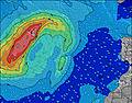 |  |  | 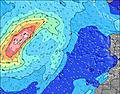 |  | ||||||||||||
Oleaje Altura (m) Dirección Período (s) | NNE 7 | NNE 7 | NNE 6 | NNE 6 | NNE 6 | NNE 6 | NNE 6 | NNE 6 | NNE 6 | NNE 6 | NNE 6 | NNE 6 | NNE 6 | NNE 7 | NNE 7 | NNE 7 | NNE 7 | NNE 7 | NNE 7 |
Gráfico Olas | |||||||||||||||||||
96 | 77 | 108 | 98 | 103 | 103 | 87 | 115 | 121 | 159 | 182 | 203 | 197 | 209 | 216 | 192 | 210 | 210 | 198 | |
Viento (km/h) | |||||||||||||||||||
Estado del Viento Viento de Mar Viento de Mar-Cruzado Cruzado Viento de Tierra-Cruzado Viento de Tierra Cristalino | on | on | on | on | on | on | on | on | on | on | on | on | on | on | on | on | on | on | on |
Marea alta | 3:58PM2.15m | 4:19AM1.93m | 4:31PM2.11m | 4:54AM1.90m | 5:07PM2.03m | ||||||||||||||
Marea baja | 10:11PM0.19m | 10:14AM0.27m | 10:44PM0.22m | 10:50AM0.32m | |||||||||||||||
— | — | — | — | — | 7:24 | — | — | — | — | — | — | — | 7:24 | — | — | — | — | — | |
— | 8:52 | — | — | — | — | — | — | — | 8:51 | — | — | — | — | — | — | — | 8:51 | — | |
mm | — | — | — | — | — | — | — | — | — | — | — | — | — | — | — | — | — | — | — |
Temp. °C | 26 | 25 | 24 | 24 | 24 | 24 | 27 | 27 | 26 | 25 | 24 | 23 | 22 | 23 | 25 | 26 | 26 | 25 | 24 |
Enfriamiento °C | 27 | 26 | 24 | 25 | 24 | 24 | 27 | 27 | 25 | 24 | 23 | 23 | 22 | 23 | 25 | 26 | 25 | 24 | 24 |
Oleaje 1 Altura (m) Dirección Período (s) | NW 9 | NW 9 | NW 9 | NW 9 | WNW 9 | NW 9 | NW 8 | NW 8 | NW 8 | NW 8 | NW 10 | NW 9 | N 10 | NW 9 | N 9 | N 9 | NW 9 | NW 10 | NW 10 |
42 | 41 | 41 | 40 | 31 | 19 | 18 | 18 | 18 | 10 | 23 | 22 | 28 | 21 | 26 | 26 | 13 | 15 | 15 | |
Oleaje 2 Altura (m) Dirección Período (s) | N 10 | N 9 | N 9 | N 9 | N 9 | N 9 | N 9 | S 13 | — | WNW 10 | — | N 10 | NW 9 | SW 12 | NW 9 | NW 9 | — | S 12 | S 12 |
29 | 27 | 15 | 15 | 15 | 15 | 15 | 3 | — | 9 | — | 30 | 21 | 6 | 20 | 12 | — | 3 | 3 | |
Oleaje 3 Altura (m) Dirección Período (s) | S 15 | S 15 | S 15 | S 15 | S 14 | S 13 | S 13 | S 11 | S 11 | S 13 | S 13 | S 13 | N 8 | — | NW 11 | NW 11 | S 10 | S 10 | S 10 |
4 | 4 | 4 | 4 | 4 | 4 | 3 | 2 | 2 | 3 | 3 | 3 | 6 | — | 5 | 5 | 2 | 2 | 2 | |
Olas de Viento Altura (m) Dirección Período (s) | NNE 7 | NNE 7 | NNE 6 | NNE 6 | NNE 6 | NNE 6 | NNE 6 | NNE 6 | NNE 6 | NNE 6 | NNE 6 | NNE 6 | NNE 6 | NNE 7 | NNE 7 | NNE 7 | NNE 7 | NNE 7 | NNE 7 |
96 | 77 | 108 | 98 | 103 | 103 | 87 | 115 | 121 | 159 | 182 | 203 | 197 | 209 | 216 | 192 | 210 | 210 | 198 | |
Viento del Tierra o Mar Limpio más proximo | |||||||||||||||||||
Distancia (km) | 37 | 37 | 37 | 37 | 37 | 37 | 91 | 0 | 102 | 111 | 111 | 47 | 111 | 118 | 73 | 73 | 73 | 73 | 73 |
Mejores Olas Previstas en Gran Canaria | |||||||||||||||||||
Mejores Olas Previstas en Spain (Africa) | |||||||||||||||||||
Busca-Olas Global | |||||||||||||||||||
- Map Icons:
 Break
Break Live Wave Height (m)
 Live Wind Speed (km/h)
 Surf Rating (10 Max)
 Ocean Swells (m)
- Wind Speed (km/h)
GRÁTIS! Un widget de Surf-Forecast.com para tu sitio
Este widget grátis de previsiones de surf y tiempo puede ser añadido a cualquier otro sitio y da un resumen de previsiones de olas para Quintanilla. Solo necesita cortar y pegar el código HTML de abajo en su web. Puede elegir preferencias de idioma y de unidades (métricas o imperiales) para convenir a los usuarios de su sitio. Clica aquí para obtener el código.
 Nearest