
Previsiones:

Pronóstico Corto PlazoLluvia ligera (totál 3mm), cayendo mayormente el domingo por la tarde. Very mild (max 13°C el lunes por la mañana, min 8°C el sábado por la noche). Vientos decreciente (vientos frescos desde el SO el sábado por la mañana, calma por la noche de sábado). | ||||||||||||||||||||||||
sábado 1 | domingo 2 | lunes 3 | ||||||||||||||||||||||
12 AM | 3 AM | 6 AM | 9 AM | 12 PM | 3 PM | 6 PM | 9 PM | 12 AM | 3 AM | 6 AM | 9 AM | 12 PM | 3 PM | 6 PM | 9 PM | 12 AM | 3 AM | 6 AM | 9 AM | 12 PM | 3 PM | 6 PM | 9 PM | |
Mapa de Altura de Olas |  | 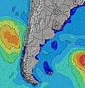 | 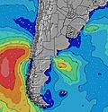 | 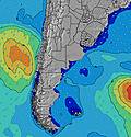 | 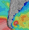 | 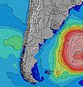 | 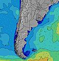 | 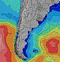 | 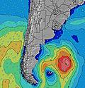 | |||||||||||||||
Oleaje Altura (m) Dirección Período (s) | ENE 8 | ENE 8 | E 8 | SW 5 | E 10 | E 10 | E 10 | E 10 | E 10 | E 10 | SSW 7 | E 10 | SSE 13 | S 12 | S 11 | S 11 | SSE 11 | SSE 10 | SSE 10 | SSE 10 | SSE 10 | SSE 10 | SE 10 | SE 10 |
Gráfico Olas | ||||||||||||||||||||||||
104 | 87 | 90 | 92 | 130 | 138 | 100 | 102 | 108 | 75 | 75 | 74 | 53 | 100 | 160 | 231 | 286 | 339 | 298 | 298 | 320 | 320 | 304 | 265 | |
Viento (km/h) | ||||||||||||||||||||||||
Estado del Viento Viento de Mar Viento de Mar-Cruzado Cruzado Viento de Tierra-Cruzado Viento de Tierra Cristalino | cross-on | cross-on | cross-on | cross-on | cross-on | cross-on | cross-on | cross-on | glassy | off | off | off | off | off | glassy | off | off | off | cross | cross-off | glassy | cross-off | cross | cross-off |
Marea alta | 8:57AM1.23m | 8:40PM1.75m | 9:30AM1.28m | 9:20PM1.73m | 10:05AM1.35m | |||||||||||||||||||
Marea baja | 3:33AM0.07m | 2:59PM0.61m | 4:12AM0.07m | 3:48PM0.57m | 4:49AM0.10m | 4:36PM0.52m | ||||||||||||||||||
— | — | 7:56 | — | — | — | — | — | — | — | 7:54 | — | — | — | — | — | — | — | 7:54 | — | — | — | — | — | |
— | — | — | — | — | — | 6:05 | — | — | — | — | — | — | — | 6:06 | — | — | — | — | — | — | — | 6:07 | — | |
mm | — | — | — | — | — | — | — | — | — | — | — | — | — | — | 2 | 1 | — | — | — | — | — | — | — | — |
Temp. °C | 14 | 13 | 12 | 10 | 10 | 10 | 10 | 9 | 8 | 8 | 8 | 8 | 10 | 12 | 11 | 10 | 11 | 11 | 12 | 12 | 13 | 13 | 13 | 12 |
Enfriamiento °C | 11 | 9 | 6 | 4 | 4 | 6 | 7 | 7 | 7 | 5 | 4 | 4 | 6 | 9 | 10 | 5 | 8 | 9 | 11 | 11 | 13 | 12 | 12 | 11 |
Oleaje 1 Altura (m) Dirección Período (s) | ENE 8 | ENE 8 | E 8 | E 9 | E 10 | E 10 | SSW 6 | SSW 6 | SSW 6 | SSW 6 | SSW 7 | SSW 7 | SSW 7 | S 12 | S 11 | S 11 | SSE 11 | SSE 10 | SSE 10 | SSE 10 | SSE 10 | SSE 10 | SE 10 | SE 10 |
104 | 87 | 90 | 74 | 130 | 138 | 70 | 66 | 68 | 57 | 62 | 47 | 35 | 100 | 160 | 231 | 286 | 339 | 298 | 298 | 320 | 320 | 304 | 265 | |
Oleaje 2 Altura (m) Dirección Período (s) | S 8 | S 8 | S 8 | E 10 | — | — | E 10 | E 10 | E 10 | E 10 | E 10 | E 10 | E 10 | SSW 7 | ENE 10 | — | ENE 4 | E 5 | E 5 | ENE 5 | ENE 5 | ENE 8 | ENE 8 | SW 5 |
5 | 5 | 5 | 33 | — | — | 100 | 102 | 108 | 75 | 75 | 74 | 50 | 25 | 31 | — | 13 | 17 | 14 | 9 | 6 | 24 | 14 | 7 | |
Oleaje 3 Altura (m) Dirección Período (s) | S 9 | S 9 | — | — | — | — | — | S 11 | S 16 | S 15 | SSE 14 | SSE 13 | SSE 13 | E 10 | SSW 6 | — | ENE 9 | ENE 9 | ENE 9 | ENE 9 | ENE 9 | S 10 | S 10 | ENE 8 |
2 | 2 | — | — | — | — | — | 2 | 5 | 17 | 38 | 34 | 53 | 49 | 15 | — | 17 | 16 | 16 | 15 | 15 | 2 | 2 | 14 | |
Olas de Viento Altura (m) Dirección Período (s) | WSW 3 | WSW 4 | WSW 5 | SW 5 | SW 5 | SW 6 | — | — | — | — | — | NE 3 | NE 3 | NE 3 | NNE 3 | ENE 9 | NE 5 | NNW 3 | — | — | — | W 3 | SW 5 | WSW 5 |
5 | 18 | 56 | 92 | 103 | 80 | — | — | — | — | — | 2 | 3 | 4 | 7 | 76 | 38 | 1 | — | — | — | 2 | 7 | 20 | |
Viento del Tierra o Mar Limpio más proximo | ||||||||||||||||||||||||
Distancia (km) | 114 | 287 | 468 | 227 | 300 | 114 | 1 | 1 | 0 | 0 | 0 | 0 | 0 | 0 | 0 | 0 | 0 | 0 | 1 | 0 | 0 | 0 | 1 | 0 |
Mejores Olas Previstas en Provincia de Buenos Aires | ||||||||||||||||||||||||
Mejores Olas Previstas en Argentina | ||||||||||||||||||||||||
Busca-Olas Global | ||||||||||||||||||||||||
- Map Icons:
 Break
Break Live Wave Height (m)
 Live Wind Speed (km/h)
 Surf Rating (10 Max)
 Ocean Swells (m)
- Wind Speed (km/h)
GRÁTIS! Un widget de Surf-Forecast.com para tu sitio
Este widget grátis de previsiones de surf y tiempo puede ser añadido a cualquier otro sitio y da un resumen de previsiones de olas para Quequen. Solo necesita cortar y pegar el código HTML de abajo en su web. Puede elegir preferencias de idioma y de unidades (métricas o imperiales) para convenir a los usuarios de su sitio. Clica aquí para obtener el código.
 Nearest