
Previsiones:

Pronóstico Corto PlazoFuerte lluvia (totál 42mm), más pesada durante la noche de jueves. Very mild (max 16°C el miércoles por la tarde, min 12°C el viernes por la tarde). Vientos crecientes (Vientos ligeros desde el NE el miércoles por la mañana, vientos fuertes desde el NNE por la noche de jueves). | ||||||||||||||||||||||||
miércoles 29 | jueves 30 | viernes 31 | ||||||||||||||||||||||
2 AM | 5 AM | 8 AM | 11 AM | 2 PM | 5 PM | 8 PM | 11 PM | 2 AM | 5 AM | 8 AM | 11 AM | 2 PM | 5 PM | 8 PM | 11 PM | 2 AM | 5 AM | 8 AM | 11 AM | 2 PM | 5 PM | 8 PM | 11 PM | |
Mapa de Altura de Olas |  | 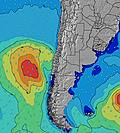 |  |  | 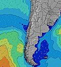 |  |  | 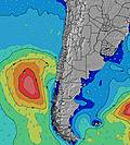 |  | |||||||||||||||
Oleaje Altura (m) Dirección Período (s) | W 12 | W 12 | W 12 | W 12 | W 11 | W 11 | W 11 | W 11 | WSW 12 | W 12 | W 12 | W 11 | W 11 | WNW 11 | WNW 10 | WNW 10 | NW 10 | NW 10 | NW 10 | NW 9 | NW 9 | WSW 10 | WSW 10 | WSW 10 |
Gráfico Olas | ||||||||||||||||||||||||
617 | 615 | 464 | 376 | 418 | 289 | 235 | 188 | 228 | 228 | 276 | 441 | 669 | 850 | 1109 | 1003 | 1679 | 696 | 782 | 374 | 363 | 370 | 410 | 342 | |
Viento (km/h) | ||||||||||||||||||||||||
Estado del Viento Viento de Mar Viento de Mar-Cruzado Cruzado Viento de Tierra-Cruzado Viento de Tierra Cristalino | glassy | glassy | off | cross-off | cross-off | on | cross-off | cross-off | cross-off | cross-off | cross-off | cross-off | cross-off | cross-off | cross-off | cross-off | cross-off | cross-on | cross | cross-off | cross | cross | cross-off | cross-off |
Marea alta | 10:28AM1.43m | 10:57PM0.92m | 11:01AM1.45m | 11:29PM0.96m | 11:32AM1.43m | |||||||||||||||||||
Marea baja | 3:52AM0.24m | 5:11PM0.12m | 4:27AM0.21m | 5:41PM0.10m | 5:02AM0.20m | 6:10PM0.10m | ||||||||||||||||||
— | 7:43 | — | — | — | — | — | — | — | 7:41 | — | — | — | — | — | — | — | 7:41 | — | — | — | — | — | — | |
— | — | — | — | — | 6:06 | — | — | — | — | — | — | — | 6:06 | — | — | — | — | — | — | — | 6:07 | — | — | |
mm | — | — | — | — | — | — | — | — | — | — | — | — | — | — | — | — | — | 13 | 10 | 3 | 7 | 7 | 1 | 1 |
Temp. °C | 13 | 13 | 13 | 14 | 16 | 14 | 14 | 14 | 13 | 13 | 13 | 14 | 15 | 15 | 15 | 15 | 15 | 13 | 13 | 14 | 12 | 12 | 13 | 13 |
Enfriamiento °C | 13 | 12 | 12 | 13 | 13 | 11 | 13 | 12 | 10 | 10 | 9 | 9 | 9 | 8 | 8 | 7 | 6 | 7 | 9 | 11 | 5 | 5 | 8 | 10 |
Oleaje 1 Altura (m) Dirección Período (s) | W 12 | W 12 | W 12 | W 12 | W 11 | W 11 | W 11 | W 11 | WSW 12 | W 12 | W 12 | W 11 | W 11 | WNW 11 | WNW 10 | WNW 10 | WSW 12 | NW 10 | W 11 | NW 9 | NW 9 | NW 9 | WSW 10 | WSW 10 |
617 | 615 | 464 | 376 | 418 | 289 | 235 | 188 | 228 | 228 | 276 | 441 | 669 | 850 | 1109 | 1003 | 418 | 696 | 457 | 365 | 357 | 294 | 410 | 342 | |
Oleaje 2 Altura (m) Dirección Período (s) | SSW 8 | SW 8 | SSW 8 | SSW 8 | SW 8 | WSW 13 | WSW 13 | WSW 13 | SW 8 | SSW 8 | SSW 8 | SSW 8 | SW 14 | SW 13 | WSW 13 | WSW 12 | WSW 18 | W 11 | WSW 17 | W 10 | WSW 10 | WSW 10 | NW 9 | NW 9 |
86 | 65 | 40 | 39 | 31 | 102 | 154 | 96 | 15 | 11 | 6 | 6 | 33 | 7 | 70 | 244 | 31 | 526 | 29 | 374 | 363 | 370 | 231 | 202 | |
Oleaje 3 Altura (m) Dirección Período (s) | WSW 16 | — | WSW 15 | SW 15 | NW 15 | SSW 8 | SSW 8 | SSW 8 | SSW 12 | SSW 12 | SSW 12 | SSW 12 | SW 8 | WSW 15 | — | NW 13 | — | SW 18 | WSW 17 | WSW 16 | WSW 16 | WSW 16 | WSW 16 | WSW 13 |
25 | — | 43 | 104 | 8 | 26 | 26 | 25 | 15 | 14 | 14 | 15 | 2 | 22 | — | 7 | — | 12 | 29 | 26 | 51 | 51 | 98 | 202 | |
Olas de Viento Altura (m) Dirección Período (s) | — | — | — | — | — | — | — | — | NNE 3 | NNE 3 | NNE 3 | NNE 4 | NNE 4 | NNE 5 | NNE 5 | NNE 6 | NW 10 | N 7 | NW 10 | N 6 | N 5 | N 6 | N 6 | NNE 6 |
— | — | — | — | — | — | — | — | 3 | 3 | 4 | 15 | 40 | 84 | 117 | 232 | 1679 | 150 | 782 | 78 | 61 | 101 | 88 | 64 | |
Viento del Tierra o Mar Limpio más proximo | ||||||||||||||||||||||||
Distancia (km) | 0 | 0 | 0 | 0 | 28 | 75 | 0 | 0 | 22 | 22 | 22 | 140 | 1332 | 179 | 140 | 140 | 179 | 140 | 34 | 179 | 167 | 140 | 65 | 0 |
Mejores Olas Previstas en Santiago | ||||||||||||||||||||||||
Mejores Olas Previstas en Chile | ||||||||||||||||||||||||
Busca-Olas Global | ||||||||||||||||||||||||
- Map Icons:
 Break
Break Live Wave Height (m)
 Live Wind Speed (km/h)
 Surf Rating (10 Max)
 Ocean Swells (m)
- Wind Speed (km/h)
GRÁTIS! Un widget de Surf-Forecast.com para tu sitio
Este widget grátis de previsiones de surf y tiempo puede ser añadido a cualquier otro sitio y da un resumen de previsiones de olas para Punta Topocalma. Solo necesita cortar y pegar el código HTML de abajo en su web. Puede elegir preferencias de idioma y de unidades (métricas o imperiales) para convenir a los usuarios de su sitio. Clica aquí para obtener el código.
 Nearest