
Previsiones:

Pronóstico Corto PlazoMayormente seco. Warm (max 22°C el martes por la mañana, min 18°C el martes por la noche). El viento será generalmente ligero. | ||||||||||||||||||
lun 27 | martes 28 | miércoles 29 | ||||||||||||||||
8 PM | 11 PM | 2 AM | 5 AM | 8 AM | 11 AM | 2 PM | 5 PM | 8 PM | 11 PM | 2 AM | 5 AM | 8 AM | 11 AM | 2 PM | 5 PM | 8 PM | 11 PM | |
Mapa de Altura de Olas |  | 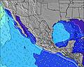 |  |  |  |  |  | |||||||||||
Oleaje Altura (m) Dirección Período (s) | SW 17 | SW 17 | SW 17 | SW 17 | SW 17 | SW 17 | SSW 17 | SW 17 | SW 16 | SSW 16 | SSW 16 | SSW 16 | SW 16 | SW 16 | SSW 16 | SSW 16 | SSW 16 | SSW 15 |
Gráfico Olas | ||||||||||||||||||
805 | 854 | 885 | 1235 | 1221 | 1193 | 1305 | 1124 | 1097 | 993 | 993 | 981 | 748 | 739 | 843 | 832 | 978 | 837 | |
Viento (km/h) | ||||||||||||||||||
Estado del Viento Viento de Mar Viento de Mar-Cruzado Cruzado Viento de Tierra-Cruzado Viento de Tierra Cristalino | cross | cross | cross | glassy | glassy | cross-on | cross-on | cross | cross | cross | cross-on | glassy | cross-on | cross-on | cross-on | cross-on | cross | cross-on |
Marea alta | 8:11PM2.09m | 9:52AM1.45m | 8:44PM2.12m | 10:16AM1.49m | 9:16PM2.12m | |||||||||||||
Marea baja | 3:25AM0.18m | 2:31PM0.95m | 3:53AM0.16m | 3:05PM0.91m | ||||||||||||||
— | — | — | 5:58 | — | — | — | — | — | — | — | 5:58 | — | — | — | — | — | — | |
— | — | — | — | — | — | — | 7:42 | — | — | — | — | — | — | — | 7:40 | — | — | |
mm | — | — | — | — | — | — | — | — | — | — | — | — | — | — | — | — | — | — |
Temp. °C | 21 | 20 | 19 | 19 | 20 | 22 | 22 | 22 | 20 | 19 | 18 | 18 | 19 | 22 | 22 | 22 | 20 | 19 |
Enfriamiento °C | 22 | 21 | 20 | 21 | 22 | 22 | 22 | 22 | 21 | 20 | 19 | 19 | 20 | 22 | 22 | 22 | 21 | 20 |
Oleaje 1 Altura (m) Dirección Período (s) | SW 17 | SW 17 | SW 17 | SW 17 | SW 17 | SW 17 | SSW 17 | SW 17 | SW 16 | SSW 16 | SSW 16 | SSW 16 | SW 16 | SW 16 | SSW 16 | SSW 16 | SSW 16 | SSW 15 |
805 | 854 | 885 | 1235 | 1221 | 1193 | 1305 | 1124 | 1097 | 993 | 993 | 981 | 748 | 739 | 843 | 832 | 978 | 837 | |
Oleaje 2 Altura (m) Dirección Período (s) | WNW 8 | WNW 8 | WNW 8 | WNW 8 | WNW 8 | WNW 8 | WNW 8 | WNW 8 | WNW 8 | WNW 8 | WNW 8 | WNW 8 | S 15 | S 15 | S 14 | S 13 | S 13 | S 13 |
103 | 103 | 103 | 100 | 95 | 91 | 88 | 88 | 88 | 91 | 93 | 105 | 343 | 418 | 395 | 352 | 273 | 268 | |
Oleaje 3 Altura (m) Dirección Período (s) | SW 12 | SW 12 | SSW 11 | S 9 | S 17 | S 16 | S 9 | S 16 | S 16 | S 15 | S 15 | S 14 | WNW 8 | WNW 8 | WNW 8 | WNW 8 | WNW 8 | WNW 8 |
36 | 71 | 48 | 2 | 51 | 46 | 2 | 195 | 183 | 209 | 208 | 199 | 84 | 71 | 69 | 69 | 103 | 108 | |
Olas de Viento Altura (m) Dirección Período (s) | — | — | — | — | — | — | — | — | — | — | — | — | — | — | — | — | — | — |
— | — | — | — | — | — | — | — | — | — | — | — | — | — | — | — | — | — | |
Viento del Tierra o Mar Limpio más proximo | ||||||||||||||||||
Distancia (km) | 115 | 115 | 115 | 0 | 0 | 358 | 228 | 442 | 115 | 115 | 32 | 0 | 32 | 358 | 228 | 448 | 115 | 115 |
Mejores Olas Previstas en Baja Norte | ||||||||||||||||||
Mejores Olas Previstas en Mexico | ||||||||||||||||||
Busca-Olas Global | ||||||||||||||||||
- Map Icons:
 Break
Break Live Wave Height (m)
 Live Wind Speed (km/h)
 Surf Rating (10 Max)
 Ocean Swells (m)
- Wind Speed (km/h)
GRÁTIS! Un widget de Surf-Forecast.com para tu sitio
Este widget grátis de previsiones de surf y tiempo puede ser añadido a cualquier otro sitio y da un resumen de previsiones de olas para Punta San Jacinto (Shipwrecks). Solo necesita cortar y pegar el código HTML de abajo en su web. Puede elegir preferencias de idioma y de unidades (métricas o imperiales) para convenir a los usuarios de su sitio. Clica aquí para obtener el código.
 Nearest