

Punta Hughes Surf Guide
Punta Hughes in Baja Sur is an exposed point break that has reasonably consistent surf Offshore winds are from the northeast. Tends to receive distant groundswells and the best swell direction is from the southwest.. Rarely crowded here. Take care of rocks in the line up.
Punta Hughes Spot Info
| Type: | Rating: | Reliability: | Todays Sea Temp*: |
|---|---|---|---|
| fairly consistent | 27.2°C*ocean temperature recorded from satellite |
Surfing Punta Hughes:
The best conditions reported for surf at Punta Hughes occur when a Southwest swell combines with an offshore wind direction from the Northeast.
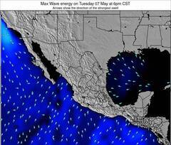
Energía de Olas (poder): 12 horas


Punta Hughes Surf:
Thursday, 23 July 2026, 00:43 Local time| mié | jue | |||
| 8PM | 11PM | 2AM | 5AM | |
| Wave (m) | ||||
| Período (s) | 11 | 11 | 10 | 12 |
| Viento (km/h) | ||||
| Estado del Viento | cross | cross | cross | cross |
- /breaks/Punta-Hughes/forecasts/latest
Punta Hughes Surf Guide
Punta Hughes in Baja Sur is an exposed point break that has reasonably consistent surf Offshore winds are from the northeast. Tends to receive distant groundswells and the best swell direction is from the southwest.. Rarely crowded here. Take care of rocks in the line up.
Punta Hughes Spot Info
Type: Rating: Reliability: Todays Sea Temp*:  Point
Point 2
2fairly consistent 27.2°C*ocean temperature recorded from satelliteSurfing Punta Hughes:
The best conditions reported for surf at Punta Hughes occur when a Southwest swell combines with an offshore wind direction from the Northeast.
Energía de Olas (poder): 12 horas
Usa la barra de navegación de arriba para ver la temperatura del mar en Punta Hughes, fotografías Punta Hughes, previsiones detalladas de olas para Punta Hughes, vientos y previsión del tiempo, webcams para Punta Hughes, viento actual desde estaciones meteorológicas en Baja Sur y predicciones de marea para Punta Hughes. Las mapas de olas para Mexico enseñarán un mapa grande de Mexico y los mares que rodean. Los mapas de olas pueden ser animadas para mostrar diferentes componentes de olas, la altura de ola, la energía de ola, el período, junto con previsiones de viento y del tiempo. Previsiones actuales del tiempo y del estado del mar provienen de boyas marinas de Mexico, del barcos que transitan en la zona y de estaciones meteorológicas costeras. Cada página de previsiones tiene un Busca-Olas Regional y Global para localizar las mejores condiciones para surfear en el área de Punta Hughes.
Punta Hughes Surf:
Thursday, 23 July 2026, 00:43 Local timemié jue 8PM 11PM 2AM 5AM Wave (m) Período (s) 11 11 10 12 Viento (km/h) Estado del Viento cross cross cross cross - /breaks/Punta-Hughes/forecasts/latest
- /breaks/Punta-Hughes/forecasts/latest/six_day
Punta Hughes Surf Guide
Punta Hughes in Baja Sur is an exposed point break that has reasonably consistent surf Offshore winds are from the northeast. Tends to receive distant groundswells and the best swell direction is from the southwest.. Rarely crowded here. Take care of rocks in the line up.
Punta Hughes Spot Info
Type: Rating: Reliability: Todays Sea Temp*: Point2fairly consistent 27.2°C*ocean temperature recorded from satelliteSurfing Punta Hughes:
The best conditions reported for surf at Punta Hughes occur when a Southwest swell combines with an offshore wind direction from the Northeast.
Energía de Olas (poder): 12 horas
Usa la barra de navegación de arriba para ver la temperatura del mar en Punta Hughes, fotografías Punta Hughes, previsiones detalladas de olas para Punta Hughes, vientos y previsión del tiempo, webcams para Punta Hughes, viento actual desde estaciones meteorológicas en Baja Sur y predicciones de marea para Punta Hughes. Las mapas de olas para Mexico enseñarán un mapa grande de Mexico y los mares que rodean. Los mapas de olas pueden ser animadas para mostrar diferentes componentes de olas, la altura de ola, la energía de ola, el período, junto con previsiones de viento y del tiempo. Previsiones actuales del tiempo y del estado del mar provienen de boyas marinas de Mexico, del barcos que transitan en la zona y de estaciones meteorológicas costeras. Cada página de previsiones tiene un Busca-Olas Regional y Global para localizar las mejores condiciones para surfear en el área de Punta Hughes.
Punta Hughes Surf:
Thursday, 23 July 2026, 00:43 Local timemié jue 8PM 11PM 2AM 5AM Wave (m) Período (s) 11 11 10 12 Viento (km/h) Estado del Viento cross cross cross cross - /breaks/Punta-Hughes/forecasts/latest
Punta Hughes Surf Guide
Punta Hughes in Baja Sur is an exposed point break that has reasonably consistent surf Offshore winds are from the northeast. Tends to receive distant groundswells and the best swell direction is from the southwest.. Rarely crowded here. Take care of rocks in the line up.
Punta Hughes Spot Info
Type: Rating: Reliability: Todays Sea Temp*: Point2fairly consistent 27.2°C*ocean temperature recorded from satelliteSurfing Punta Hughes:
The best conditions reported for surf at Punta Hughes occur when a Southwest swell combines with an offshore wind direction from the Northeast.
Energía de Olas (poder): 12 horas
Usa la barra de navegación de arriba para ver la temperatura del mar en Punta Hughes, fotografías Punta Hughes, previsiones detalladas de olas para Punta Hughes, vientos y previsión del tiempo, webcams para Punta Hughes, viento actual desde estaciones meteorológicas en Baja Sur y predicciones de marea para Punta Hughes. Las mapas de olas para Mexico enseñarán un mapa grande de Mexico y los mares que rodean. Los mapas de olas pueden ser animadas para mostrar diferentes componentes de olas, la altura de ola, la energía de ola, el período, junto con previsiones de viento y del tiempo. Previsiones actuales del tiempo y del estado del mar provienen de boyas marinas de Mexico, del barcos que transitan en la zona y de estaciones meteorológicas costeras. Cada página de previsiones tiene un Busca-Olas Regional y Global para localizar las mejores condiciones para surfear en el área de Punta Hughes.
Punta Hughes Surf:
Thursday, 23 July 2026, 00:43 Local timemié jue 8PM 11PM 2AM 5AM Wave (m) Período (s) 11 11 10 12 Viento (km/h) Estado del Viento cross cross cross cross Tide Times:
En Punta Hughes (0 km).
PROXIMA ES A LAS (hora local) quedan marea alta marea baja Punta Hughes Tide Times and Tide Chart
Live Weather:
At SHIP2275, 163 km from Punta Hughes.
- Air temperature
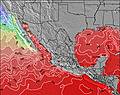
-°COverall Punta Hughes Surf Consistency and Wind Distribution in julio


Wind stats for Punta Hughes: see the variation in direction and stength by month.
Fotos de Surf
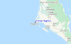
de la galeríaContornos: Carreteras y Ríos: Selecciona un spot desde el menú 


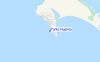
Usa este mapa para navegar hacia las playas de surf de Baja Sur y estaciones de marea cercanas de Punta Hughes
Spots de Surf más cercanos a Punta Hughes:
(Clica la ubicación para más detalles)- Closest spot61 mi
- Second closest spot84 mi
- Third closest spot91 mi
- Fourth closest spot93 mi
- Fifth closest spot103 mi
Boyas marinas más cercanas a Punta Hughes:
- Closest Boya Marinas616 mi
- Second closest Boya Marinas621 mi
- Third closest Boya Marinas636 mi
- Fourth closest Boya Marinas636 mi
- Fifth closest Boya Marinas637 mi
Estaciones de marea más cercanas a Punta Hughes:
- Closest estación de mareaSan Carlos10 mi
- Second closest estación de mareaBahia Magdalena12 mi
- Third closest estación de mareaSan Juan de la Costa102 mi
- Fourth closest estación de mareaBahia San Juanico104 mi
- Fifth closest estación de mareaLoreto104 mi
Airports
- The nearest passenger airport to Punta Hughes is Loreto International Airport (LTO) in Mexico, which is 165 km (102 miles) away (directly).
- The second closest airport to Punta Hughes is General Manuel Marquez De Leon International (La Paz) Airport (LAP), also in Mexico, 208 km (129 miles) away.

- /breaks/Punta-Hughes/forecasts/latest


 Nearest