
Previsiones:

Pronóstico Corto PlazoMayormente seco. Warm (max 24°C el jueves por la tarde, min 19°C el miércoles por la noche). El viento será generalmente ligero. | ||||||||||||||||||||||||
miércoles 15 | jueves 16 | viernes 17 | sáb 18 | |||||||||||||||||||||
8 AM | 11 AM | 2 PM | 5 PM | 8 PM | 11 PM | 2 AM | 5 AM | 8 AM | 11 AM | 2 PM | 5 PM | 8 PM | 11 PM | 2 AM | 5 AM | 8 AM | 11 AM | 2 PM | 5 PM | 8 PM | 11 PM | 2 AM | 5 AM | |
Mapa de Altura de Olas |  |  |  |  |  |  |  |  | 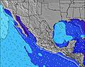 | |||||||||||||||
Oleaje Altura (m) Dirección Período (s) | SW 17 | SW 17 | SW 16 | SW 16 | SW 16 | SW 16 | SW 16 | SW 16 | SW 16 | SW 16 | SW 16 | SW 15 | SW 15 | SW 15 | SW 15 | SW 14 | SW 19 | SW 19 | SW 18 | SW 14 | SW 14 | SW 14 | SW 17 | SW 17 |
Gráfico Olas | ||||||||||||||||||||||||
107 | 102 | 130 | 127 | 161 | 161 | 159 | 159 | 159 | 122 | 119 | 109 | 136 | 134 | 134 | 132 | 129 | 103 | 102 | 102 | 102 | 99 | 147 | 190 | |
Viento (km/h) | ||||||||||||||||||||||||
Estado del Viento Viento de Mar Viento de Mar-Cruzado Cruzado Viento de Tierra-Cruzado Viento de Tierra Cristalino | cross-on | on | cross-on | cross-on | cross | glassy | glassy | glassy | glassy | on | cross-on | cross-on | cross-off | glassy | glassy | glassy | cross-on | on | cross-on | cross | cross-off | cross-off | cross-off | cross |
Marea alta | 11:00AM1.81m | 10:09PM2.54m | 11:40AM1.85m | 10:54PM2.35m | 12:19PM1.89m | 11:39PM2.10m | ||||||||||||||||||
Marea baja | 3:56PM0.99m | 5:12AM0.05m | 4:48PM0.98m | 5:49AM0.23m | 5:44PM1.00m | |||||||||||||||||||
5:48 | — | — | — | — | — | — | 5:50 | — | — | — | — | — | — | — | 5:50 | — | — | — | — | — | — | — | 5:50 | |
— | — | — | 7:37 | — | — | — | — | — | — | — | 7:37 | — | — | — | — | — | — | — | 7:37 | — | — | — | 7:37 | |
mm | — | — | — | — | — | — | — | — | — | — | — | — | — | — | — | — | — | — | — | — | — | — | — | — |
Temp. °C | 20 | 22 | 22 | 22 | 20 | 20 | 19 | 19 | 21 | 23 | 24 | 23 | 21 | 21 | 21 | 21 | 22 | 23 | 23 | 23 | 22 | 22 | 21 | 21 |
Enfriamiento °C | 21 | 23 | 22 | 23 | 21 | 22 | 21 | 21 | 22 | 23 | 23 | 22 | 22 | 22 | 23 | 22 | 22 | 22 | 23 | 22 | 23 | 23 | 22 | 22 |
Oleaje 1 Altura (m) Dirección Período (s) | W 5 | W 5 | SW 16 | SW 16 | SW 16 | SW 16 | SW 16 | SW 16 | SW 16 | SW 16 | SW 16 | SW 15 | SW 15 | SW 15 | SW 15 | SW 14 | WNW 9 | WNW 9 | WNW 9 | WNW 9 | WNW 9 | WNW 9 | WNW 9 | SW 17 |
13 | 12 | 130 | 127 | 161 | 161 | 159 | 159 | 159 | 122 | 119 | 109 | 136 | 134 | 134 | 132 | 71 | 71 | 71 | 54 | 53 | 53 | 54 | 190 | |
Oleaje 2 Altura (m) Dirección Período (s) | SW 17 | SW 17 | WNW 5 | SSW 12 | SSW 12 | SSW 12 | WNW 5 | WNW 5 | WNW 5 | WNW 8 | WNW 8 | NW 8 | NW 8 | WNW 8 | WNW 8 | WNW 9 | SW 14 | SW 14 | SW 14 | SW 14 | SW 14 | SW 14 | S 12 | WNW 9 |
107 | 102 | 7 | 57 | 29 | 28 | 5 | 5 | 5 | 14 | 13 | 17 | 16 | 24 | 27 | 53 | 103 | 103 | 102 | 102 | 102 | 99 | 77 | 53 | |
Oleaje 3 Altura (m) Dirección Período (s) | SSW 12 | SSW 12 | SSW 12 | WNW 5 | WNW 5 | WNW 5 | SSW 12 | SSW 12 | SSW 12 | SSW 12 | SSW 12 | SSW 11 | SSW 11 | SW 19 | SW 19 | SW 19 | SW 19 | SW 19 | SW 18 | WNW 19 | SSW 12 | SSW 12 | SW 17 | S 12 |
58 | 57 | 57 | 7 | 5 | 5 | 28 | 28 | 28 | 27 | 26 | 25 | 25 | 94 | 130 | 130 | 129 | 90 | 83 | 72 | 46 | 48 | 147 | 72 | |
Olas de Viento Altura (m) Dirección Período (s) | — | — | — | — | — | — | — | — | — | — | — | — | — | — | — | — | — | — | — | — | — | — | — | — |
— | — | — | — | — | — | — | — | — | — | — | — | — | — | — | — | — | — | — | — | — | — | — | — | |
Viento del Tierra o Mar Limpio más proximo | ||||||||||||||||||||||||
Distancia (km) | 117 | 117 | 434 | 367 | 318 | 367 | 140 | 117 | 140 | 615 | 367 | 615 | 117 | 140 | 140 | 140 | 367 | 367 | 615 | 367 | 323 | 117 | 117 | 117 |
Mejores Olas Previstas en Baja Norte | ||||||||||||||||||||||||
Mejores Olas Previstas en Mexico | ||||||||||||||||||||||||
Busca-Olas Global | ||||||||||||||||||||||||
- Map Icons:
 Break
Break Live Wave Height (m)
 Live Wind Speed (km/h)
 Surf Rating (10 Max)
 Ocean Swells (m)
- Wind Speed (km/h)
GRÁTIS! Un widget de Surf-Forecast.com para tu sitio
Este widget grátis de previsiones de surf y tiempo puede ser añadido a cualquier otro sitio y da un resumen de previsiones de olas para Punta Cono. Solo necesita cortar y pegar el código HTML de abajo en su web. Puede elegir preferencias de idioma y de unidades (métricas o imperiales) para convenir a los usuarios de su sitio. Clica aquí para obtener el código.
 Nearest