
Previsiones:

Pronóstico Corto PlazoLluvia moderada (totál 10mm), más pesada el lunes por la noche. Warm (max 24°C el lunes por la noche, min 21°C el domingo por la noche). El viento será generalmente ligero. | |||||||||||||||||
lunes 3 | martes 4 | ||||||||||||||||
9 PM | 12 AM | 3 AM | 6 AM | 9 AM | 12 PM | 3 PM | 6 PM | 9 PM | 12 AM | 3 AM | 6 AM | 9 AM | 12 PM | 3 PM | 6 PM | 9 PM | |
Mapa de Altura de Olas |  |  | 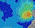 |  |  | 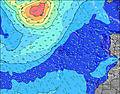 |  | ||||||||||
Oleaje Altura (m) Dirección Período (s) | W 10 | W 10 | W 9 | W 9 | W 9 | W 10 | W 10 | W 10 | W 10 | N 9 | W 10 | W 10 | W 10 | W 9 | W 9 | NNE 10 | NNE 10 |
Gráfico Olas | |||||||||||||||||
186 | 148 | 136 | 136 | 142 | 145 | 183 | 186 | 184 | 151 | 226 | 220 | 216 | 205 | 201 | 205 | 230 | |
Viento (km/h) | |||||||||||||||||
Estado del Viento Viento de Mar Viento de Mar-Cruzado Cruzado Viento de Tierra-Cruzado Viento de Tierra Cristalino | cross | cross | cross | cross-on | cross-on | glassy | cross-off | cross-off | off | cross-off | cross-off | cross-off | cross-off | cross-off | cross-off | cross-off | cross-off |
Marea alta | 4:46AM1.10m | 5:04PM1.19m | 5:27AM1.06m | 5:45PM1.14m | |||||||||||||
Marea baja | 10:43PM0.16m | 10:46AM0.18m | 11:21PM0.19m | 11:27AM0.24m | |||||||||||||
— | — | — | 6:56 | — | — | — | — | — | — | — | 6:58 | — | — | — | — | — | |
9:05 | — | — | — | — | — | — | — | 9:04 | — | — | — | — | — | — | — | 9:02 | |
mm | — | — | — | — | — | — | — | — | — | 3 | 3 | 2 | — | — | — | — | — |
Temp. °C | 21 | 21 | 21 | 21 | 21 | 22 | 22 | 23 | 23 | 24 | 24 | 23 | 22 | 22 | 22 | 22 | 23 |
Enfriamiento °C | 22 | 23 | 22 | 22 | 22 | 24 | 23 | 25 | 25 | 24 | 24 | 24 | 24 | 23 | 22 | 22 | 23 |
Oleaje 1 Altura (m) Dirección Período (s) | W 10 | W 10 | W 9 | W 9 | W 9 | W 10 | W 10 | W 10 | N 9 | N 9 | W 10 | W 10 | N 8 | W 9 | W 9 | NNE 10 | NNE 10 |
186 | 148 | 136 | 136 | 142 | 145 | 183 | 186 | 150 | 146 | 226 | 220 | 140 | 205 | 201 | 205 | 218 | |
Oleaje 2 Altura (m) Dirección Período (s) | NNW 7 | NW 7 | NNW 7 | NNW 7 | NNW 7 | N 9 | N 9 | N 9 | W 10 | W 10 | N 8 | N 8 | S 12 | NNE 8 | NNE 8 | S 12 | S 13 |
41 | 47 | 41 | 40 | 29 | 78 | 101 | 152 | 184 | 151 | 140 | 140 | 12 | 147 | 154 | 12 | 12 | |
Oleaje 3 Altura (m) Dirección Período (s) | NNE 9 | NNE 9 | NNE 9 | N 9 | N 9 | NNW 6 | NNW 6 | S 14 | S 14 | S 13 | S 12 | S 12 | S 18 | S 12 | S 12 | S 16 | S 16 |
26 | 26 | 26 | 41 | 59 | 23 | 15 | 15 | 15 | 14 | 12 | 12 | 6 | 12 | 12 | 5 | 5 | |
Olas de Viento Altura (m) Dirección Período (s) | — | — | — | — | — | — | — | S 4 | S 7 | SSW 3 | SSW 4 | SSW 4 | W 10 | SW 4 | SW 4 | W 9 | W 9 |
— | — | — | — | — | — | — | 1 | 1 | 6 | 8 | 6 | 216 | 4 | 4 | 198 | 230 | |
Viento del Tierra o Mar Limpio más proximo | |||||||||||||||||
Distancia (km) | 14 | 14 | 14 | 14 | 14 | 0 | 0 | 0 | 0 | 70 | 70 | 70 | 0 | 70 | 73 | 132 | 70 |
Mejores Olas Previstas en The Azores | |||||||||||||||||
Mejores Olas Previstas en Portugal | |||||||||||||||||
Busca-Olas Global | |||||||||||||||||
- Map Icons:
 Break
Break Live Wave Height (m)
 Live Wind Speed (km/h)
 Surf Rating (10 Max)
 Ocean Swells (m)
- Wind Speed (km/h)
GRÁTIS! Un widget de Surf-Forecast.com para tu sitio
Este widget grátis de previsiones de surf y tiempo puede ser añadido a cualquier otro sitio y da un resumen de previsiones de olas para Faial - Praia do Norte. Solo necesita cortar y pegar el código HTML de abajo en su web. Puede elegir preferencias de idioma y de unidades (métricas o imperiales) para convenir a los usuarios de su sitio. Clica aquí para obtener el código.
 Nearest