

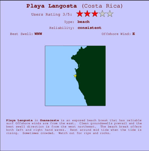
Playa Langosta Surf Guide
Playa Langosta in Guanacaste is an exposed beach break that has reliable surf The best wind direction is from the east. Most of the surf here comes from groundswells and the best swell direction is from the west northwest. The beach break provides left and right handers. Best around mid tide when the tide is rising. Sometimes crowded. Hazards include rips and rocks.
Playa Langosta Spot Info
| Type: | Rating: | Reliability: | Todays Sea Temp*: |
|---|---|---|---|
| consistent | 30.2°C*ocean temperature recorded from satellite |
Surfing Playa Langosta:
The best conditions reported for surf at Playa Langosta occur when a West-northwest swell combines with an offshore wind direction from the East.

Energía de Olas (poder): 12 horas


Playa Langosta Surf:
Thursday, 16 July 2026, 09:43 Local time| jueves 16 | ||||
| 9AM | 12PM | 3PM | 6PM | |
| Wave (m) | ||||
| Período (s) | 13 | 13 | 13 | 14 |
| Viento (km/h) | ||||
| Estado del Viento | cross- off |
cross- off |
off | cross- off |
- /breaks/Playa-Langosta/forecasts/latest
Playa Langosta Surf Guide
Playa Langosta in Guanacaste is an exposed beach break that has reliable surf The best wind direction is from the east. Most of the surf here comes from groundswells and the best swell direction is from the west northwest. The beach break provides left and right handers. Best around mid tide when the tide is rising. Sometimes crowded. Hazards include rips and rocks.
Playa Langosta Spot Info
Type: Rating: Reliability: Todays Sea Temp*:  Beach
Beach 3
3consistent 30.2°C*ocean temperature recorded from satelliteSurfing Playa Langosta:
The best conditions reported for surf at Playa Langosta occur when a West-northwest swell combines with an offshore wind direction from the East.
Energía de Olas (poder): 12 horas
Usa la barra de navegación de arriba para ver la temperatura del mar en Playa Langosta, fotografías Playa Langosta, previsiones detalladas de olas para Playa Langosta, vientos y previsión del tiempo, webcams para Playa Langosta, viento actual desde estaciones meteorológicas en Guanacaste y predicciones de marea para Playa Langosta. Las mapas de olas para Costa Rica enseñarán un mapa grande de Costa Rica y los mares que rodean. Los mapas de olas pueden ser animadas para mostrar diferentes componentes de olas, la altura de ola, la energía de ola, el período, junto con previsiones de viento y del tiempo. Previsiones actuales del tiempo y del estado del mar provienen de boyas marinas de Costa Rica, del barcos que transitan en la zona y de estaciones meteorológicas costeras. Cada página de previsiones tiene un Busca-Olas Regional y Global para localizar las mejores condiciones para surfear en el área de Playa Langosta.
Playa Langosta Surf:
Thursday, 16 July 2026, 09:43 Local timejueves 16 9AM 12PM 3PM 6PM Wave (m) Período (s) 13 13 13 14 Viento (km/h) Estado del Viento cross-
offcross-
offoff cross-
off- /breaks/Playa-Langosta/forecasts/latest
- /breaks/Playa-Langosta/forecasts/latest/six_day
Playa Langosta Surf Guide
Playa Langosta in Guanacaste is an exposed beach break that has reliable surf The best wind direction is from the east. Most of the surf here comes from groundswells and the best swell direction is from the west northwest. The beach break provides left and right handers. Best around mid tide when the tide is rising. Sometimes crowded. Hazards include rips and rocks.
Playa Langosta Spot Info
Type: Rating: Reliability: Todays Sea Temp*: Beach3consistent 30.2°C*ocean temperature recorded from satelliteSurfing Playa Langosta:
The best conditions reported for surf at Playa Langosta occur when a West-northwest swell combines with an offshore wind direction from the East.
Energía de Olas (poder): 12 horas
Usa la barra de navegación de arriba para ver la temperatura del mar en Playa Langosta, fotografías Playa Langosta, previsiones detalladas de olas para Playa Langosta, vientos y previsión del tiempo, webcams para Playa Langosta, viento actual desde estaciones meteorológicas en Guanacaste y predicciones de marea para Playa Langosta. Las mapas de olas para Costa Rica enseñarán un mapa grande de Costa Rica y los mares que rodean. Los mapas de olas pueden ser animadas para mostrar diferentes componentes de olas, la altura de ola, la energía de ola, el período, junto con previsiones de viento y del tiempo. Previsiones actuales del tiempo y del estado del mar provienen de boyas marinas de Costa Rica, del barcos que transitan en la zona y de estaciones meteorológicas costeras. Cada página de previsiones tiene un Busca-Olas Regional y Global para localizar las mejores condiciones para surfear en el área de Playa Langosta.
Playa Langosta Surf:
Thursday, 16 July 2026, 09:43 Local timejueves 16 9AM 12PM 3PM 6PM Wave (m) Período (s) 13 13 13 14 Viento (km/h) Estado del Viento cross-
offcross-
offoff cross-
off- /breaks/Playa-Langosta/forecasts/latest
Playa Langosta Surf Guide
Playa Langosta in Guanacaste is an exposed beach break that has reliable surf The best wind direction is from the east. Most of the surf here comes from groundswells and the best swell direction is from the west northwest. The beach break provides left and right handers. Best around mid tide when the tide is rising. Sometimes crowded. Hazards include rips and rocks.
Playa Langosta Spot Info
Type: Rating: Reliability: Todays Sea Temp*: Beach3consistent 30.2°C*ocean temperature recorded from satelliteSurfing Playa Langosta:
The best conditions reported for surf at Playa Langosta occur when a West-northwest swell combines with an offshore wind direction from the East.
Energía de Olas (poder): 12 horas
Usa la barra de navegación de arriba para ver la temperatura del mar en Playa Langosta, fotografías Playa Langosta, previsiones detalladas de olas para Playa Langosta, vientos y previsión del tiempo, webcams para Playa Langosta, viento actual desde estaciones meteorológicas en Guanacaste y predicciones de marea para Playa Langosta. Las mapas de olas para Costa Rica enseñarán un mapa grande de Costa Rica y los mares que rodean. Los mapas de olas pueden ser animadas para mostrar diferentes componentes de olas, la altura de ola, la energía de ola, el período, junto con previsiones de viento y del tiempo. Previsiones actuales del tiempo y del estado del mar provienen de boyas marinas de Costa Rica, del barcos que transitan en la zona y de estaciones meteorológicas costeras. Cada página de previsiones tiene un Busca-Olas Regional y Global para localizar las mejores condiciones para surfear en el área de Playa Langosta.
Playa Langosta Surf:
Thursday, 16 July 2026, 09:43 Local timejueves 16 9AM 12PM 3PM 6PM Wave (m) Período (s) 13 13 13 14 Viento (km/h) Estado del Viento cross-
offcross-
offoff cross-
offTide Times:
Para Diria, a %{dist} %{km} de %{location}.
PROXIMA ES A LAS (hora local) quedan marea alta marea baja Playa Langosta Tide Times and Tide Chart
Live Weather:
At Liberia/Tomas Guardia Airport, 50 km from Playa Langosta.
light winds from the NE
(km/h)Air temperature
A2976°COverall Playa Langosta Surf Consistency and Wind Distribution in julio


Wind stats for Playa Langosta: see the variation in direction and stength by month.
Fotos de Surf
de la galeríaContornos: Carreteras y Ríos: Selecciona un spot desde el menú 


Usa este mapa para navegar hacia las playas de surf de Guanacaste y estaciones de marea cercanas de Playa Langosta
Spots de Surf más cercanos a Playa Langosta:
(Clica la ubicación para más detalles)- Closest spot0 mi
- Second closest spot2 mi
- Third closest spot2 mi
- Fourth closest spot3 mi
- Fifth closest spot3 mi
Boyas marinas más cercanas a Playa Langosta:
- Closest Boya Marinas540 mi
- Second closest Boya Marinas666 mi
- Third closest Boya Marinas977 mi
- Fourth closest Boya Marinas1076 mi
- Fifth closest Boya Marinas1086 mi
Estaciones de marea más cercanas a Playa Langosta:
- Closest estación de mareaSan Juan del Sur68 mi
- Second closest estación de mareaPunta Arenas73 mi
- Third closest estación de mareaChacarita76 mi
- Fourth closest estación de mareaMasachapa114 mi
- Fifth closest estación de mareaSan Juan del Norte (Greytown)154 mi
Airports
- The closest passenger airport to Playa Langosta is Nosara Airport (NOB) in Costa Rica, which is 39 km (24 miles) away (directly).
- The second nearest airport to Playa Langosta is Daniel Oduber Quiros International (Liberia) Airport (LIR), also in Costa Rica, 50 km (31 miles) away.
- The third closest airport is Juan Santamaria International Airport (SJO), also in Costa Rica, 183 km (114 miles) away.
- /breaks/Playa-Langosta/forecasts/latest


 Nearest