
Previsiones:

Pronóstico Corto PlazoMayormente seco. Warm (max 22°C el lunes por la mañana, min 18°C el sábado por la noche). El viento será generalmente ligero. | |||||||||||||||||||||||
sábado 18 | domingo 19 | lunes 20 | |||||||||||||||||||||
4 AM | 7 AM | 10 AM | 1 PM | 4 PM | 7 PM | 10 PM | 1 AM | 4 AM | 7 AM | 10 AM | 1 PM | 4 PM | 7 PM | 10 PM | 1 AM | 4 AM | 7 AM | 10 AM | 1 PM | 4 PM | 7 PM | 10 PM | |
Mapa de Altura de Olas |  |  | 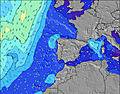 |  | 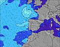 |  |  | 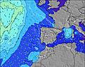 | 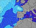 | ||||||||||||||
Oleaje Altura (m) Dirección Período (s) | WNW 8 | WNW 8 | WNW 8 | NW 5 | NW 5 | NW 5 | NW 5 | NW 5 | NNW 6 | NNW 6 | NNW 6 | NW 6 | NNW 6 | NW 5 | NNW 5 | NW 8 | NNW 7 | NNW 7 | NW 7 | NW 7 | NW 7 | NW 7 | NNW 7 |
Gráfico Olas | |||||||||||||||||||||||
13 | 13 | 13 | 17 | 22 | 26 | 28 | 39 | 57 | 63 | 65 | 52 | 24 | 35 | 17 | 20 | 35 | 54 | 71 | 71 | 84 | 86 | 61 | |
Viento (km/h) | |||||||||||||||||||||||
Estado del Viento Viento de Mar Viento de Mar-Cruzado Cruzado Viento de Tierra-Cruzado Viento de Tierra Cristalino | cross-on | cross-on | cross-on | on | on | cross-on | cross-on | cross-on | cross-on | on | on | on | on | on | on | on | on | glassy | cross-on | cross-on | cross-on | on | on |
Marea alta | 6:23AM2.73m | 6:40PM3.00m | 7:08AM2.60m | 7:26PM2.78m | 7:55AM2.45m | 8:14PM2.53m | |||||||||||||||||
Marea baja | 12:20PM0.26m | 00:58AM0.24m | 1:05PM0.43m | 1:42AM0.44m | 1:53PM0.61m | ||||||||||||||||||
6:20 | — | — | — | — | — | — | — | 6:22 | — | — | — | — | — | — | — | 6:22 | — | — | — | — | — | — | |
— | — | — | — | — | 9:00 | — | — | — | — | — | — | — | 9:00 | — | — | — | — | — | — | — | 9:00 | — | |
mm | — | — | — | — | — | — | — | — | — | — | — | — | — | — | — | — | — | — | — | — | — | — | — |
Temp. °C | 18 | 18 | 19 | 20 | 20 | 20 | 19 | 18 | 19 | 19 | 19 | 20 | 21 | 21 | 21 | 20 | 19 | 19 | 21 | 22 | 22 | 20 | 20 |
Enfriamiento °C | 18 | 19 | 19 | 20 | 19 | 20 | 19 | 18 | 19 | 19 | 19 | 20 | 20 | 21 | 22 | 21 | 21 | 21 | 21 | 22 | 22 | 20 | 22 |
Oleaje 1 Altura (m) Dirección Período (s) | NW 4 | NW 4 | NW 4 | WNW 8 | WNW 8 | WNW 8 | WNW 8 | NW 5 | NNW 6 | NNW 6 | NNW 6 | NW 6 | NNW 6 | W 9 | NNW 5 | NNW 6 | NNW 7 | NNW 7 | NW 7 | NW 7 | NW 7 | NW 7 | NNW 7 |
7 | 8 | 9 | 13 | 13 | 13 | 13 | 39 | 57 | 63 | 65 | 52 | 24 | 14 | 17 | 20 | 35 | 54 | 71 | 71 | 84 | 86 | 61 | |
Oleaje 2 Altura (m) Dirección Período (s) | WNW 8 | WNW 8 | WNW 8 | W 5 | W 5 | — | W 11 | W 8 | W 8 | WNW 8 | NW 8 | WNW 7 | WNW 7 | WNW 7 | WNW 4 | WNW 4 | WNW 4 | W 4 | W 8 | W 8 | W 8 | W 8 | W 5 |
13 | 13 | 13 | 1 | 1 | — | 2 | 5 | 5 | 11 | 14 | 11 | 5 | 5 | 6 | 6 | 6 | 6 | 12 | 11 | 10 | 10 | 11 | |
Oleaje 3 Altura (m) Dirección Período (s) | SW 6 | SW 5 | W 5 | — | — | W 19 | N 11 | NW 8 | NW 8 | NW 10 | NW 10 | NW 9 | W 9 | NNW 9 | WNW 8 | NW 8 | NW 8 | W 8 | NW 8 | WNW 12 | WNW 11 | WNW 11 | WNW 11 |
1 | 1 | 1 | — | — | 7 | 2 | 3 | 2 | 4 | 4 | 3 | 6 | 8 | 14 | 17 | 17 | 12 | 11 | 15 | 13 | 12 | 12 | |
Olas de Viento Altura (m) Dirección Período (s) | — | — | — | NW 5 | NW 5 | NW 5 | NW 5 | — | — | — | — | — | WNW 5 | NW 5 | — | — | — | — | — | — | — | — | — |
— | — | — | 17 | 22 | 26 | 28 | — | — | — | — | — | 7 | 35 | — | — | — | — | — | — | — | — | — | |
Viento del Tierra o Mar Limpio más proximo | |||||||||||||||||||||||
Distancia (km) | 463 | 271 | 1043 | 1470 | 1085 | 1043 | 214 | 112 | 28 | 80 | 60 | 340 | 344 | 437 | 162 | 24 | 24 | 0 | 72 | 564 | 299 | 214 | 85 |
Mejores Olas Previstas en Beira | |||||||||||||||||||||||
Mejores Olas Previstas en Portugal | |||||||||||||||||||||||
Busca-Olas Global | |||||||||||||||||||||||
- Map Icons:
 Break
Break Live Wave Height (m)
 Live Wind Speed (km/h)
 Surf Rating (10 Max)
 Ocean Swells (m)
- Wind Speed (km/h)
GRÁTIS! Un widget de Surf-Forecast.com para tu sitio
Este widget grátis de previsiones de surf y tiempo puede ser añadido a cualquier otro sitio y da un resumen de previsiones de olas para Pedrogao. Solo necesita cortar y pegar el código HTML de abajo en su web. Puede elegir preferencias de idioma y de unidades (métricas o imperiales) para convenir a los usuarios de su sitio. Clica aquí para obtener el código.
 Nearest