
Previsiones:

Pronóstico Corto PlazoLluvia ligera (totál 6mm), cayendo mayormente el sábado por la noche. Warm (max 29°C el jueves por la tarde, min 20°C el jueves por la noche). Vientos crecientes (Vientos ligeros desde el N el jueves por la noche, vientos frescos desde el S por la noche de sábado). | |||||||||||||||||||||
jue 16 | viernes 17 | sábado 18 | |||||||||||||||||||
11 AM | 2 PM | 5 PM | 8 PM | 11 PM | 2 AM | 5 AM | 8 AM | 11 AM | 2 PM | 5 PM | 8 PM | 11 PM | 2 AM | 5 AM | 8 AM | 11 AM | 2 PM | 5 PM | 8 PM | 11 PM | |
Mapa de Altura de Olas |  |  |  | 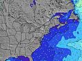 |  |  | 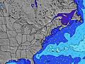 |  | |||||||||||||
Oleaje Altura (m) Dirección Período (s) | SSW 6 | S 15 | S 15 | S 15 | SSW 5 | SSW 5 | S 5 | SSW 5 | S 5 | S 14 | S 14 | SE 14 | SSW 6 | S 6 | S 6 | SE 14 | SE 14 | SE 13 | SE 13 | SE 13 | SE 13 |
Gráfico Olas | |||||||||||||||||||||
10 | 4 | 4 | 4 | 26 | 20 | 13 | 9 | 14 | 4 | 4 | 8 | 10 | 16 | 15 | 7 | 7 | 7 | 7 | 7 | 7 | |
Viento (km/h) | |||||||||||||||||||||
Estado del Viento Viento de Mar Viento de Mar-Cruzado Cruzado Viento de Tierra-Cruzado Viento de Tierra Cristalino | cross-off | cross-off | cross-off | cross-off | cross-on | cross-on | on | cross-on | cross-off | cross-off | cross-off | cross-off | cross-off | cross-off | cross-off | off | off | off | off | off | off |
Marea alta | 10:36AM0.84m | 10:54PM0.98m | 11:29AM0.85m | 11:43PM0.91m | 12:20PM0.86m | ||||||||||||||||
Marea baja | 4:42PM-0.04m | 5:23AM-0.09m | 5:37PM-0.00m | 6:08AM-0.07m | 6:32PM0.04m | ||||||||||||||||
— | — | — | — | — | — | 5:28 | — | — | — | — | — | — | — | 5:28 | — | — | — | — | — | — | |
— | — | — | 8:17 | — | — | — | — | — | — | — | 8:16 | — | — | — | — | — | — | — | 8:15 | — | |
mm | — | — | — | — | — | — | — | — | — | — | — | — | — | — | — | — | — | — | 1 | — | 1 |
Temp. °C | 25 | 28 | 29 | 26 | 25 | 23 | 20 | 20 | 24 | 27 | 27 | 25 | 22 | 22 | 21 | 22 | 24 | 22 | 21 | 20 | 22 |
Enfriamiento °C | 23 | 23 | 26 | 25 | 23 | 23 | 19 | 17 | 21 | 23 | 23 | 22 | 20 | 21 | 21 | 22 | 22 | 20 | 19 | 17 | 20 |
Oleaje 1 Altura (m) Dirección Período (s) | SSW 6 | SE 8 | SE 8 | SE 9 | SSW 5 | SSW 5 | S 5 | SSW 5 | S 5 | SE 8 | SE 8 | SE 8 | SSW 6 | S 6 | S 6 | SE 8 | SE 8 | SE 8 | SE 8 | SE 13 | SE 13 |
10 | 3 | 3 | 3 | 26 | 20 | 13 | 9 | 14 | 3 | 3 | 3 | 10 | 16 | 15 | 3 | 3 | 3 | 3 | 7 | 7 | |
Oleaje 2 Altura (m) Dirección Período (s) | SE 8 | S 15 | S 15 | S 15 | SE 9 | SE 9 | SE 9 | SE 9 | SE 9 | S 14 | S 14 | SE 14 | SE 8 | SE 8 | SE 8 | SE 14 | SE 14 | SE 13 | SE 13 | — | SE 13 |
3 | 4 | 4 | 4 | 3 | 3 | 3 | 3 | 3 | 4 | 4 | 8 | 3 | 3 | 3 | 7 | 7 | 7 | 7 | — | 7 | |
Oleaje 3 Altura (m) Dirección Período (s) | S 15 | — | — | — | S 15 | S 15 | S 15 | S 15 | S 14 | — | — | — | SE 14 | SE 14 | SE 14 | — | — | — | — | — | — |
4 | — | — | — | 4 | 5 | 4 | 4 | 4 | — | — | — | 8 | 8 | 8 | — | — | — | — | — | — | |
Olas de Viento Altura (m) Dirección Período (s) | — | SW 6 | SSW 4 | SSW 5 | — | — | — | — | — | S 6 | SSW 6 | SSW 6 | SSW 4 | SW 4 | SSW 5 | SSW 5 | S 5 | SSW 4 | S 4 | S 4 | S 5 |
— | 32 | 29 | 38 | — | — | — | — | — | 16 | 26 | 25 | 5 | 6 | 17 | 10 | 14 | 15 | 13 | 37 | 90 | |
Viento del Tierra o Mar Limpio más proximo | |||||||||||||||||||||
Distancia (km) | 50 | 1173 | 1083 | 32 | 50 | 1083 | 636 | 1067 | 2521 | 636 | 636 | 644 | 1083 | 1067 | 644 | 644 | 2606 | 2606 | 317 | 438 | 1423 |
Mejores Olas Previstas en Rhode Island | |||||||||||||||||||||
Mejores Olas Previstas en United States | |||||||||||||||||||||
Busca-Olas Global | |||||||||||||||||||||
- Map Icons:
 Break
Break Live Wave Height (m)
 Live Wind Speed (km/h)
 Surf Rating (10 Max)
 Ocean Swells (m)
- Wind Speed (km/h)
GRÁTIS! Un widget de Surf-Forecast.com para tu sitio
Este widget grátis de previsiones de surf y tiempo puede ser añadido a cualquier otro sitio y da un resumen de previsiones de olas para Panic Point (Weekapaug). Solo necesita cortar y pegar el código HTML de abajo en su web. Puede elegir preferencias de idioma y de unidades (métricas o imperiales) para convenir a los usuarios de su sitio. Clica aquí para obtener el código.
 Nearest