
Previsiones:

Pronóstico Corto PlazoLluvia ligera (totál 4mm), cayendo mayormente el viernes por la mañana. Warm (max 28°C el viernes por la mañana, min 26°C el viernes por la noche). El viento será generalmente ligero. | |||||||||||||||||||||||
viernes 17 | sábado 18 | domingo 19 | |||||||||||||||||||||
4 AM | 7 AM | 10 AM | 1 PM | 4 PM | 7 PM | 10 PM | 1 AM | 4 AM | 7 AM | 10 AM | 1 PM | 4 PM | 7 PM | 10 PM | 1 AM | 4 AM | 7 AM | 10 AM | 1 PM | 4 PM | 7 PM | 10 PM | |
Mapa de Altura de Olas | 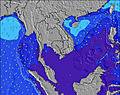 | 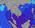 |  | 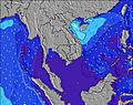 | 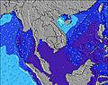 | 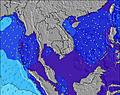 | 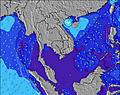 | 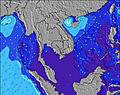 | 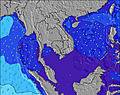 | ||||||||||||||
Oleaje Altura (m) Dirección Período (s) | W 8 | W 8 | W 8 | W 8 | SW 16 | SW 16 | SW 15 | SW 15 | SW 15 | SW 15 | SW 15 | SW 15 | SW 14 | SW 14 | SW 14 | SW 14 | SW 14 | SW 14 | SW 14 | SW 14 | SW 14 | SW 14 | SW 13 |
Gráfico Olas | |||||||||||||||||||||||
127 | 103 | 99 | 99 | 124 | 121 | 116 | 112 | 141 | 139 | 136 | 134 | 132 | 103 | 102 | 102 | 100 | 100 | 99 | 68 | 65 | 64 | 63 | |
Viento (km/h) | |||||||||||||||||||||||
Estado del Viento Viento de Mar Viento de Mar-Cruzado Cruzado Viento de Tierra-Cruzado Viento de Tierra Cristalino | glassy | glassy | cross-on | cross-on | cross-on | cross | glassy | cross-off | glassy | glassy | cross-on | cross-on | cross-on | cross-on | cross-on | on | on | on | cross-on | cross-on | cross-on | cross-on | cross-on |
Marea alta | 12:08PM2.62m | 00:40AM2.28m | 12:47PM2.50m | 1:20AM2.22m | 1:25PM2.32m | ||||||||||||||||||
Marea baja | 6:02AM0.22m | 6:38PM0.03m | 6:43AM0.30m | 7:14PM0.15m | 7:22AM0.43m | 7:49PM0.30m | |||||||||||||||||
6:15 | — | — | — | — | — | — | — | 6:16 | — | — | — | — | — | — | — | 6:16 | — | — | — | — | — | — | |
— | — | — | — | 6:50 | — | — | — | — | — | — | — | 6:50 | — | — | — | — | — | — | — | 6:50 | — | — | |
mm | — | — | — | 1 | 1 | 1 | — | — | — | — | — | — | — | — | — | — | — | — | — | 1 | — | — | — |
Temp. °C | 27 | 27 | 28 | 28 | 28 | 27 | 27 | 26 | 26 | 26 | 28 | 28 | 28 | 27 | 27 | 27 | 27 | 27 | 28 | 28 | 28 | 28 | 27 |
Enfriamiento °C | 32 | 32 | 31 | 31 | 31 | 31 | 32 | 30 | 31 | 31 | 33 | 32 | 31 | 30 | 31 | 31 | 31 | 30 | 31 | 30 | 30 | 31 | 31 |
Oleaje 1 Altura (m) Dirección Período (s) | W 8 | W 8 | W 8 | W 8 | W 8 | W 8 | W 8 | W 8 | W 8 | W 8 | W 8 | W 8 | W 8 | W 8 | W 7 | W 7 | W 7 | W 7 | SW 14 | W 7 | SW 14 | W 7 | W 7 |
127 | 103 | 99 | 99 | 78 | 74 | 72 | 72 | 71 | 54 | 54 | 55 | 55 | 54 | 53 | 51 | 50 | 48 | 99 | 24 | 65 | 26 | 25 | |
Oleaje 2 Altura (m) Dirección Período (s) | SW 16 | SW 16 | SW 16 | SW 16 | SW 16 | SW 16 | SW 15 | SW 15 | SW 15 | SW 15 | SW 15 | SW 15 | SW 14 | SW 14 | SW 14 | SW 14 | SW 14 | SW 14 | NW 6 | SW 14 | N 6 | SW 14 | SW 13 |
90 | 90 | 90 | 89 | 124 | 121 | 116 | 112 | 141 | 139 | 136 | 134 | 132 | 103 | 102 | 102 | 100 | 100 | 1 | 68 | 1 | 64 | 63 | |
Oleaje 3 Altura (m) Dirección Período (s) | — | — | — | — | — | — | — | — | — | — | W 9 | NW 6 | NW 6 | NW 6 | NW 6 | NW 6 | NW 6 | NW 6 | — | N 6 | — | — | — |
— | — | — | — | — | — | — | — | — | — | 2 | 1 | 1 | 1 | 1 | 1 | 1 | 1 | — | 1 | — | — | — | |
Olas de Viento Altura (m) Dirección Período (s) | — | — | — | — | — | — | — | — | — | — | — | — | — | — | — | — | — | — | W 7 | W 4 | W 7 | W 4 | W 4 |
— | — | — | — | — | — | — | — | — | — | — | — | — | — | — | — | — | — | 48 | 13 | 48 | 12 | 14 | |
Viento del Tierra o Mar Limpio más proximo | |||||||||||||||||||||||
Distancia (km) | 0 | 0 | 82 | 82 | 102 | 82 | 0 | 0 | 0 | 0 | 82 | 82 | 82 | 82 | 82 | 82 | 102 | 102 | 668 | 732 | 739 | 739 | 102 |
Mejores Olas Previstas en Andaman Sea | |||||||||||||||||||||||
Mejores Olas Previstas en Thailand | |||||||||||||||||||||||
Busca-Olas Global | |||||||||||||||||||||||
- Map Icons:
 Break
Break Live Wave Height (m)
 Live Wind Speed (km/h)
 Surf Rating (10 Max)
 Ocean Swells (m)
- Wind Speed (km/h)
GRÁTIS! Un widget de Surf-Forecast.com para tu sitio
Este widget grátis de previsiones de surf y tiempo puede ser añadido a cualquier otro sitio y da un resumen de previsiones de olas para Cape Pakarang Right. Solo necesita cortar y pegar el código HTML de abajo en su web. Puede elegir preferencias de idioma y de unidades (métricas o imperiales) para convenir a los usuarios de su sitio. Clica aquí para obtener el código.
 Nearest