
Previsiones:

Pronóstico Corto PlazoMayormente seco. Warm (max 27°C el domingo por la noche, min 25°C el martes por la mañana). Mayormente vientos frescos. | |||||||||||||||||||
dom 26 | lunes 27 | martes 28 | |||||||||||||||||
3 PM | 6 PM | 9 PM | 12 AM | 3 AM | 6 AM | 9 AM | 12 PM | 3 PM | 6 PM | 9 PM | 12 AM | 3 AM | 6 AM | 9 AM | 12 PM | 3 PM | 6 PM | 9 PM | |
Mapa de Altura de Olas | 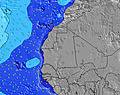 | 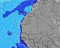 | 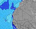 | 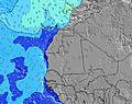 | 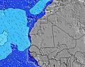 | 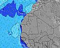 | 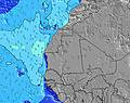 | ||||||||||||
Oleaje Altura (m) Dirección Período (s) | NNW 9 | NNW 9 | NNW 9 | NNW 9 | NNW 9 | NNW 9 | NNW 8 | NNW 8 | NNW 8 | NNW 8 | NNW 8 | NNW 8 | NNW 8 | N 8 | NNW 8 | NNW 8 | NNW 7 | NNW 7 | NNW 7 |
Gráfico Olas | |||||||||||||||||||
169 | 166 | 158 | 158 | 158 | 158 | 154 | 147 | 119 | 112 | 116 | 87 | 119 | 61 | 149 | 142 | 157 | 139 | 145 | |
Viento (km/h) | |||||||||||||||||||
Estado del Viento Viento de Mar Viento de Mar-Cruzado Cruzado Viento de Tierra-Cruzado Viento de Tierra Cristalino | off | off | cross-off | cross | cross-on | cross-on | on | on | on | cross-on | cross-on | cross-on | cross-on | cross-on | cross-on | cross-on | cross-on | cross-on | cross-on |
Marea alta | 7:35PM0.88m | 7:58AM1.06m | 8:17PM0.94m | 8:37AM1.14m | 8:54PM0.99m | ||||||||||||||
Marea baja | 1:26PM0.31m | 1:25AM0.27m | 2:11PM0.26m | 2:08AM0.22m | 2:50PM0.20m | ||||||||||||||
— | — | — | — | — | 6:50 | — | — | — | — | — | — | — | 6:52 | — | — | — | — | — | |
— | 7:40 | — | — | — | — | — | — | — | 7:40 | — | — | — | — | — | — | — | 7:40 | — | |
mm | — | — | — | — | — | — | — | — | — | — | — | — | — | — | — | — | — | — | — |
Temp. °C | 26 | 26 | 27 | 26 | 26 | 26 | 26 | 26 | 26 | 26 | 26 | 26 | 26 | 26 | 25 | 25 | 26 | 26 | 25 |
Enfriamiento °C | 28 | 29 | 30 | 28 | 29 | 29 | 29 | 29 | 29 | 28 | 28 | 26 | 27 | 27 | 25 | 25 | 26 | 26 | 25 |
Oleaje 1 Altura (m) Dirección Período (s) | NNW 9 | NNW 9 | NNW 9 | NNW 9 | NNW 9 | NNW 9 | NNW 8 | NNW 8 | NNW 8 | NNW 8 | NNW 8 | NNW 8 | SSW 7 | N 8 | SSW 7 | SSW 7 | SSW 7 | SW 7 | SW 7 |
169 | 166 | 158 | 158 | 158 | 158 | 154 | 147 | 119 | 112 | 116 | 87 | 38 | 61 | 26 | 26 | 26 | 16 | 16 | |
Oleaje 2 Altura (m) Dirección Período (s) | S 8 | S 8 | S 8 | S 8 | S 8 | S 8 | S 8 | S 8 | S 8 | SSW 8 | SSW 7 | SSW 7 | SW 12 | SSW 7 | SW 11 | SW 11 | SSW 13 | SSW 7 | S 7 |
33 | 33 | 33 | 33 | 32 | 31 | 29 | 29 | 42 | 44 | 42 | 40 | 5 | 37 | 5 | 5 | 17 | 15 | 8 | |
Oleaje 3 Altura (m) Dirección Período (s) | SSW 12 | SSW 12 | SSW 12 | SW 12 | SW 12 | SW 12 | SW 12 | SW 12 | SSW 12 | SW 12 | SW 13 | SW 12 | NW 9 | SW 11 | NW 9 | SW 13 | NW 9 | SSW 13 | SSW 13 |
15 | 15 | 15 | 6 | 6 | 6 | 6 | 6 | 15 | 6 | 6 | 5 | 3 | 5 | 3 | 7 | 3 | 17 | 17 | |
Olas de Viento Altura (m) Dirección Período (s) | — | — | — | W 3 | WSW 3 | — | — | — | — | NW 2 | NW 3 | WNW 3 | NNW 8 | NW 4 | NNW 8 | NNW 8 | NNW 7 | NNW 7 | NNW 7 |
— | — | — | 1 | 1 | — | — | — | — | 1 | 2 | 4 | 119 | 26 | 149 | 142 | 157 | 139 | 145 | |
Viento del Tierra o Mar Limpio más proximo | |||||||||||||||||||
Distancia (km) | 0 | 0 | 0 | 645 | 645 | 644 | 58 | 1470 | 10 | 614 | 614 | 611 | 611 | 611 | 611 | 611 | 611 | 611 | 611 |
Mejores Olas Previstas en Senegal | |||||||||||||||||||
Mejores Olas Previstas en Senegal | |||||||||||||||||||
Busca-Olas Global | |||||||||||||||||||
- Map Icons:
 Break
Break Live Wave Height (m)
 Live Wind Speed (km/h)
 Surf Rating (10 Max)
 Ocean Swells (m)
- Wind Speed (km/h)
GRÁTIS! Un widget de Surf-Forecast.com para tu sitio
Este widget grátis de previsiones de surf y tiempo puede ser añadido a cualquier otro sitio y da un resumen de previsiones de olas para Ngor Rights. Solo necesita cortar y pegar el código HTML de abajo en su web. Puede elegir preferencias de idioma y de unidades (métricas o imperiales) para convenir a los usuarios de su sitio. Clica aquí para obtener el código.
 Nearest