

Navegantes Surf Guide
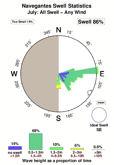
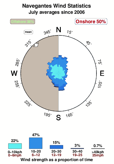
Navegantes in Santa Caterina is an exposed beach/jetty break that is often working. Winter is the optimum time of year for surfing here. Works best in offshore winds from the west. Groundswells more frequent than windswells and the best swell direction is from the southeast. The beach breaks favour rights. It's sometimes crowded here. Beware of rips and fishing lines.
Navegantes Spot Info
| Type: | Rating: | Reliability: | Todays Sea Temp*: |
|---|---|---|---|
| very consistent | 19.2°C*ocean temperature recorded from satellite |
Surfing Navegantes:
The best conditions reported for surf at Navegantes occur when a Southeast swell combines with an offshore wind direction from the West.
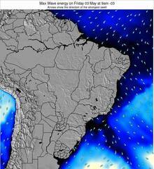
Energía de Olas (poder): 12 horas


Navegantes Surf:
Thursday, 30 July 2026, 23:22 Local time| viernes 31 | ||||
| 0AM | 3AM | 6AM | 9AM | |
| Wave (m) | ||||
| Período (s) | 7 | 7 | 13 | 13 |
| Viento (km/h) | ||||
| Estado del Viento | glass | glass | glass | cross- off |
- /breaks/Navegantes/forecasts/latest
Navegantes Surf Guide
Navegantes in Santa Caterina is an exposed beach/jetty break that is often working. Winter is the optimum time of year for surfing here. Works best in offshore winds from the west. Groundswells more frequent than windswells and the best swell direction is from the southeast. The beach breaks favour rights. It's sometimes crowded here. Beware of rips and fishing lines.
Navegantes Spot Info
Type: Rating: Reliability: Todays Sea Temp*:  Beach/jetty
 2
2very consistent 19.2°C*ocean temperature recorded from satelliteSurfing Navegantes:
The best conditions reported for surf at Navegantes occur when a Southeast swell combines with an offshore wind direction from the West.
Energía de Olas (poder): 12 horas
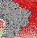
Usa la barra de navegación de arriba para ver la temperatura del mar en Navegantes, fotografías Navegantes, previsiones detalladas de olas para Navegantes, vientos y previsión del tiempo, webcams para Navegantes, viento actual desde estaciones meteorológicas en Santa Catarina - Norte y predicciones de marea para Navegantes. Las mapas de olas para Brazil enseñarán un mapa grande de Brazil y los mares que rodean. Los mapas de olas pueden ser animadas para mostrar diferentes componentes de olas, la altura de ola, la energía de ola, el período, junto con previsiones de viento y del tiempo. Previsiones actuales del tiempo y del estado del mar provienen de boyas marinas de Brazil, del barcos que transitan en la zona y de estaciones meteorológicas costeras. Cada página de previsiones tiene un Busca-Olas Regional y Global para localizar las mejores condiciones para surfear en el área de Navegantes.
Navegantes Surf:
Thursday, 30 July 2026, 23:22 Local timeviernes 31 0AM 3AM 6AM 9AM Wave (m) Período (s) 7 7 13 13 Viento (km/h) Estado del Viento glass glass glass cross-
off- /breaks/Navegantes/forecasts/latest
- /breaks/Navegantes/forecasts/latest/six_day
Navegantes Surf Guide
Navegantes in Santa Caterina is an exposed beach/jetty break that is often working. Winter is the optimum time of year for surfing here. Works best in offshore winds from the west. Groundswells more frequent than windswells and the best swell direction is from the southeast. The beach breaks favour rights. It's sometimes crowded here. Beware of rips and fishing lines.
Navegantes Spot Info
Type: Rating: Reliability: Todays Sea Temp*: Beach/jetty2very consistent 19.2°C*ocean temperature recorded from satelliteSurfing Navegantes:
The best conditions reported for surf at Navegantes occur when a Southeast swell combines with an offshore wind direction from the West.
Energía de Olas (poder): 12 horas
Usa la barra de navegación de arriba para ver la temperatura del mar en Navegantes, fotografías Navegantes, previsiones detalladas de olas para Navegantes, vientos y previsión del tiempo, webcams para Navegantes, viento actual desde estaciones meteorológicas en Santa Catarina - Norte y predicciones de marea para Navegantes. Las mapas de olas para Brazil enseñarán un mapa grande de Brazil y los mares que rodean. Los mapas de olas pueden ser animadas para mostrar diferentes componentes de olas, la altura de ola, la energía de ola, el período, junto con previsiones de viento y del tiempo. Previsiones actuales del tiempo y del estado del mar provienen de boyas marinas de Brazil, del barcos que transitan en la zona y de estaciones meteorológicas costeras. Cada página de previsiones tiene un Busca-Olas Regional y Global para localizar las mejores condiciones para surfear en el área de Navegantes.
Navegantes Surf:
Thursday, 30 July 2026, 23:22 Local timeviernes 31 0AM 3AM 6AM 9AM Wave (m) Período (s) 7 7 13 13 Viento (km/h) Estado del Viento glass glass glass cross-
off- /breaks/Navegantes/forecasts/latest
Navegantes Surf Guide
Navegantes in Santa Caterina is an exposed beach/jetty break that is often working. Winter is the optimum time of year for surfing here. Works best in offshore winds from the west. Groundswells more frequent than windswells and the best swell direction is from the southeast. The beach breaks favour rights. It's sometimes crowded here. Beware of rips and fishing lines.
Navegantes Spot Info
Type: Rating: Reliability: Todays Sea Temp*: Beach/jetty2very consistent 19.2°C*ocean temperature recorded from satelliteSurfing Navegantes:
The best conditions reported for surf at Navegantes occur when a Southeast swell combines with an offshore wind direction from the West.
Energía de Olas (poder): 12 horas
Usa la barra de navegación de arriba para ver la temperatura del mar en Navegantes, fotografías Navegantes, previsiones detalladas de olas para Navegantes, vientos y previsión del tiempo, webcams para Navegantes, viento actual desde estaciones meteorológicas en Santa Catarina - Norte y predicciones de marea para Navegantes. Las mapas de olas para Brazil enseñarán un mapa grande de Brazil y los mares que rodean. Los mapas de olas pueden ser animadas para mostrar diferentes componentes de olas, la altura de ola, la energía de ola, el período, junto con previsiones de viento y del tiempo. Previsiones actuales del tiempo y del estado del mar provienen de boyas marinas de Brazil, del barcos que transitan en la zona y de estaciones meteorológicas costeras. Cada página de previsiones tiene un Busca-Olas Regional y Global para localizar las mejores condiciones para surfear en el área de Navegantes.
Navegantes Surf:
Thursday, 30 July 2026, 23:22 Local timeviernes 31 0AM 3AM 6AM 9AM Wave (m) Período (s) 7 7 13 13 Viento (km/h) Estado del Viento glass glass glass cross-
offTide Times:
Para Itajai, Brazil, a %{dist} %{km} de %{location}.
PROXIMA ES A LAS (hora local) quedan marea alta marea baja Navegantes Tide Times and Tide Chart
Live Weather:
At Navegantes Airport, 1 km from Navegantes.
calm
(km/h)Air temperature
17°COverall Navegantes Surf Consistency and Wind Distribution in julio
Fotos de Surf
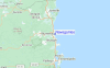
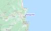
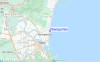
de la galeríaContornos: Carreteras y Ríos: Selecciona un spot desde el menú 


Usa este mapa para navegar hacia las playas de surf de Santa Catarina - Norte y estaciones de marea cercanas de Navegantes
Spots de Surf más cercanos a Navegantes:
(Clica la ubicación para más detalles)- Closest spot2 mi
- Second closest spot4 mi
- Third closest spot4 mi
- Fourth closest spot4 mi
- Fifth closest spot5 mi
Boyas marinas más cercanas a Navegantes:
- Closest Boya Marinas328 mi
- Second closest Boya Marinas2365 mi
- Third closest Boya Marinas2856 mi
- Fourth closest Boya Marinas2874 mi
- Fifth closest Boya Marinas2912 mi
Estaciones de marea más cercanas a Navegantes:
- Closest estación de mareaItajai1 mi
- Second closest estación de mareaBalneario Camboriu7 mi
- Third closest estación de mareaPenha8 mi
- Fourth closest estación de mareaBarra Velha17 mi
- Fifth closest estación de mareaPorto Belo19 mi
Airports
- The closest passenger airport to Navegantes is Navegantes Itajai Airport (NVT) in Brazil, 1 km (1 miles) away (directly).
- The second nearest airport to Navegantes is Joinville Airport (JOI), also in Brazil, 75 km (47 miles) away.
- Third is Hercilio Luz (Florianopolis) Airport (FLN) in Brazil, 88 km (55 miles) away.
- Afonso Pena (Curitiba) Airport (CWB) in Brazil is 160 km (99 miles) away.
- Bacacheri (Curitiba) Airport (BFH), also in Brazil is the fifth nearest airport to Navegantes and is 175 km (109 miles) away.

- /breaks/Navegantes/forecasts/latest


 Nearest