
Previsiones:

Pronóstico Corto PlazoMayormente seco. Very mild (max 13°C el miércoles por la tarde, min 11°C el miércoles por la noche). El viento será generalmente ligero. | ||||||||||||||||||||||||
miércoles 15 | jueves 16 | viernes 17 | sáb 18 | |||||||||||||||||||||
7 AM | 10 AM | 1 PM | 4 PM | 7 PM | 10 PM | 1 AM | 4 AM | 7 AM | 10 AM | 1 PM | 4 PM | 7 PM | 10 PM | 1 AM | 4 AM | 7 AM | 10 AM | 1 PM | 4 PM | 7 PM | 10 PM | 1 AM | 4 AM | |
Mapa de Altura de Olas |  | 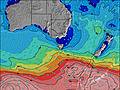 |  |  |  |  |  |  |  | |||||||||||||||
Oleaje Altura (m) Dirección Período (s) | SW 15 | SW 15 | WSW 14 | SW 14 | SW 14 | SW 15 | SW 15 | SW 15 | SW 15 | SW 15 | SW 16 | SW 15 | SW 15 | SW 15 | SW 15 | SW 16 | SW 16 | SW 16 | SW 16 | SW 16 | SW 16 | SW 15 | SW 15 | SW 14 |
Gráfico Olas | ||||||||||||||||||||||||
0 | 0 | 0 | 0 | 0 | 0 | 0 | 0 | 0 | 0 | 0 | 0 | 0 | 0 | 0 | 0 | 0 | 0 | 0 | 0 | 0 | 0 | 0 | 0 | |
Viento (km/h) | ||||||||||||||||||||||||
Estado del Viento Viento de Mar Viento de Mar-Cruzado Cruzado Viento de Tierra-Cruzado Viento de Tierra Cristalino | off | off | off | off | off | off | off | off | off | off | off | off | off | off | cross-off | off | cross-off | cross-off | cross-off | cross-off | off | cross-off | cross-off | cross-off |
Marea alta | 12:56PM2.23m | 00:37AM1.93m | 1:49PM2.29m | 1:41AM2.00m | 2:38PM2.31m | 2:41AM2.05m | ||||||||||||||||||
Marea baja | 6:03AM0.04m | 7:00PM0.72m | 7:05AM0.02m | 7:57PM0.59m | 8:02AM0.05m | 8:48PM0.45m | ||||||||||||||||||
7:41 | — | — | — | — | — | — | — | 7:41 | — | — | — | — | — | — | — | 7:39 | — | — | — | — | — | — | 7:39 | |
— | — | — | 5:16 | — | — | — | — | — | — | — | 5:16 | — | — | — | — | — | — | — | 5:17 | — | — | — | 5:19 | |
mm | — | — | — | — | — | — | — | — | — | — | — | — | — | — | — | — | — | — | — | — | — | — | — | — |
Temp. °C | 12 | 12 | 12 | 13 | 12 | 12 | 12 | 11 | 11 | 12 | 12 | 12 | 12 | 12 | 13 | 13 | 13 | 11 | 11 | 11 | 11 | 11 | 11 | 12 |
Enfriamiento °C | 7 | 8 | 8 | 9 | 8 | 9 | 9 | 8 | 8 | 9 | 9 | 9 | 9 | 10 | 11 | 10 | 10 | 8 | 8 | 8 | 9 | 9 | 9 | 10 |
Oleaje 1 Altura (m) Dirección Período (s) | — | SW 15 | SW 14 | SW 14 | SW 14 | SW 15 | SW 15 | SW 15 | SW 15 | SW 15 | SW 16 | SW 15 | SW 15 | SW 15 | SW 15 | SW 16 | SW 16 | SW 16 | SW 16 | SW 16 | SW 16 | SW 15 | SW 15 | SW 14 |
— | 1547 | 1616 | 1484 | 1736 | 1941 | 2168 | 2021 | 2168 | 2226 | 2158 | 1951 | 1606 | 1460 | 1363 | 1513 | 1855 | 1901 | 1697 | 1513 | 1366 | 1048 | 940 | 821 | |
Oleaje 2 Altura (m) Dirección Período (s) | — | — | — | — | — | — | — | — | — | — | — | — | — | — | — | — | — | — | — | — | — | — | — | — |
— | — | — | — | — | — | — | — | — | — | — | — | — | — | — | — | — | — | — | — | — | — | — | — | |
Oleaje 3 Altura (m) Dirección Período (s) | — | — | — | — | — | — | — | — | — | — | — | — | — | — | — | — | — | — | — | — | — | — | — | — |
— | — | — | — | — | — | — | — | — | — | — | — | — | — | — | — | — | — | — | — | — | — | — | — | |
Olas de Viento Altura (m) Dirección Período (s) | SW 15 | W 4 | WSW 14 | W 3 | SW 14 | SW 15 | — | — | WSW 4 | — | — | — | — | — | — | — | — | — | — | — | — | — | — | — |
1941 | 9 | 5305 | 8 | 3105 | 6339 | — | — | 7 | — | — | — | — | — | — | — | — | — | — | — | — | — | — | — | |
Viento del Tierra o Mar Limpio más proximo | ||||||||||||||||||||||||
Distancia (km) | 128 | 128 | 128 | 128 | 128 | 128 | 128 | 128 | 128 | 128 | 128 | 128 | 128 | 128 | 128 | 128 | 128 | 128 | 128 | 128 | 128 | 128 | 128 | 128 |
Mejores Olas Previstas en North Coast of Tasmania | ||||||||||||||||||||||||
Mejores Olas Previstas en Australia | ||||||||||||||||||||||||
Busca-Olas Global | ||||||||||||||||||||||||
- Map Icons:
 Break
Break Live Wave Height (m)
 Live Wind Speed (km/h)
 Surf Rating (10 Max)
 Ocean Swells (m)
- Wind Speed (km/h)
GRÁTIS! Un widget de Surf-Forecast.com para tu sitio
Este widget grátis de previsiones de surf y tiempo puede ser añadido a cualquier otro sitio y da un resumen de previsiones de olas para King Island - Narracoopa Beach. Solo necesita cortar y pegar el código HTML de abajo en su web. Puede elegir preferencias de idioma y de unidades (métricas o imperiales) para convenir a los usuarios de su sitio. Clica aquí para obtener el código.
 Nearest