
Previsiones:

Pronóstico Corto PlazoAlgo de llovizna, más pesada durante la tarde del viernes. Warm (max 25°C el sábado por la tarde, min 24°C el jueves por la mañana). Mayormente vientos frescos. | ||||||||||||||||||||||||
jueves 16 | viernes 17 | sábado 18 | ||||||||||||||||||||||
2 AM | 5 AM | 8 AM | 11 AM | 2 PM | 5 PM | 8 PM | 11 PM | 2 AM | 5 AM | 8 AM | 11 AM | 2 PM | 5 PM | 8 PM | 11 PM | 2 AM | 5 AM | 8 AM | 11 AM | 2 PM | 5 PM | 8 PM | 11 PM | |
Mapa de Altura de Olas |  | 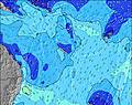 | 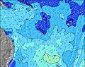 | 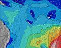 | 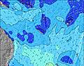 | 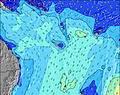 | 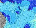 | 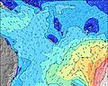 | 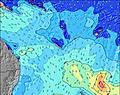 | |||||||||||||||
Oleaje Altura (m) Dirección Período (s) | ENE 8 | E 7 | SW 12 | W 12 | SW 12 | W 18 | W 12 | W 17 | W 16 | W 10 | SW 15 | SW 16 | SW 16 | SW 16 | SW 16 | SW 13 | SW 12 | SW 12 | SW 12 | W 12 | ENE 10 | SW 11 | SW 11 | SW 11 |
Gráfico Olas | ||||||||||||||||||||||||
0 | 0 | 6 | 3 | 6 | 6 | 3 | 6 | 5 | 2 | 9 | 9 | 10 | 10 | 11 | 7 | 6 | 6 | 6 | 3 | 0 | 5 | 5 | 5 | |
Viento (km/h) | ||||||||||||||||||||||||
Estado del Viento Viento de Mar Viento de Mar-Cruzado Cruzado Viento de Tierra-Cruzado Viento de Tierra Cristalino | cross | cross | cross | cross | cross | cross | cross | cross | cross | cross | cross | cross | cross | cross | cross | cross | cross | cross | cross | cross | cross | cross | cross | cross-on |
Marea alta | 5:57AM1.47m | 7:19PM1.30m | 6:47AM1.40m | 8:05PM1.30m | 7:39AM1.30m | 8:51PM1.28m | ||||||||||||||||||
Marea baja | 00:02AM0.47m | 12:43PM-0.06m | 00:55AM0.47m | 1:28PM0.03m | 1:49AM0.48m | 2:13PM0.14m | ||||||||||||||||||
— | 6:16 | — | — | — | — | — | — | — | 6:16 | — | — | — | — | — | — | — | 6:16 | — | — | — | — | — | — | |
— | — | — | — | — | 5:27 | — | — | — | — | — | — | — | 5:28 | — | — | — | — | — | — | — | 5:28 | — | — | |
mm | 1 | 1 | — | — | — | — | — | — | — | — | — | — | — | 1 | — | — | — | — | — | — | — | — | — | — |
Temp. °C | 23 | 24 | 24 | 24 | 24 | 24 | 24 | 24 | 24 | 24 | 24 | 24 | 24 | 24 | 24 | 24 | 24 | 24 | 24 | 24 | 25 | 24 | 24 | 24 |
Enfriamiento °C | 20 | 19 | 19 | 19 | 19 | 20 | 20 | 21 | 19 | 20 | 21 | 21 | 21 | 20 | 21 | 21 | 21 | 21 | 21 | 21 | 23 | 22 | 22 | 22 |
Oleaje 1 Altura (m) Dirección Período (s) | S 7 | S 12 | S 20 | S 19 | S 18 | S 18 | S 17 | S 17 | S 16 | SSW 15 | SW 15 | SW 16 | SW 16 | SW 16 | SW 16 | SW 13 | SW 12 | SW 12 | SE 20 | SE 19 | ESE 9 | ESE 18 | SE 18 | SE 17 |
4 | 3 | 8 | 7 | 7 | 25 | 24 | 6 | 21 | 22 | 9 | 9 | 10 | 10 | 11 | 7 | 6 | 6 | 15 | 15 | 16 | 32 | 49 | 47 | |
Oleaje 2 Altura (m) Dirección Período (s) | S 9 | S 20 | SW 12 | S 12 | SW 12 | W 18 | W 12 | W 11 | W 16 | W 10 | W 15 | W 14 | W 14 | W 13 | S 17 | — | E 21 | SE 20 | SW 12 | S 19 | ESE 19 | S 19 | S 18 | S 18 |
2 | 7 | 6 | 3 | 6 | 6 | 3 | 2 | 5 | 2 | 4 | 4 | 4 | 3 | 6 | — | 9 | 16 | 6 | 7 | 35 | 7 | 27 | 26 | |
Oleaje 3 Altura (m) Dirección Período (s) | S 13 | S 12 | — | W 12 | W 12 | — | — | W 17 | — | — | — | — | — | — | W 13 | W 13 | SE 21 | S 12 | S 16 | W 12 | S 19 | SW 11 | SW 11 | SW 11 |
3 | 3 | — | 3 | 3 | — | — | 6 | — | — | — | — | — | — | 3 | 3 | 17 | 3 | 5 | 3 | 7 | 5 | 5 | 5 | |
Olas de Viento Altura (m) Dirección Período (s) | ENE 8 | E 7 | E 8 | E 9 | E 9 | E 9 | E 9 | E 9 | E 9 | ENE 9 | ENE 9 | ENE 9 | ENE 9 | E 9 | ENE 9 | ENE 9 | ENE 9 | ENE 9 | ENE 9 | ENE 9 | ENE 10 | ENE 9 | ENE 9 | ENE 9 |
207 | 447 | 771 | 780 | 828 | 694 | 617 | 617 | 678 | 708 | 708 | 631 | 572 | 646 | 791 | 826 | 826 | 826 | 863 | 863 | 963 | 923 | 904 | 813 | |
Viento del Tierra o Mar Limpio más proximo | ||||||||||||||||||||||||
Distancia (km) | 548 | 548 | 548 | 558 | 548 | 548 | 548 | 548 | 548 | 548 | 548 | 548 | 548 | 548 | 548 | 548 | 548 | 548 | 548 | 548 | 548 | 548 | 548 | 31 |
Mejores Olas Previstas en Efate | ||||||||||||||||||||||||
Mejores Olas Previstas en Vanuatu | ||||||||||||||||||||||||
Busca-Olas Global | ||||||||||||||||||||||||
- Map Icons:
 Break
Break Live Wave Height (m)
 Live Wind Speed (km/h)
 Surf Rating (10 Max)
 Ocean Swells (m)
- Wind Speed (km/h)
GRÁTIS! Un widget de Surf-Forecast.com para tu sitio
Este widget grátis de previsiones de surf y tiempo puede ser añadido a cualquier otro sitio y da un resumen de previsiones de olas para Nagar. Solo necesita cortar y pegar el código HTML de abajo en su web. Puede elegir preferencias de idioma y de unidades (métricas o imperiales) para convenir a los usuarios de su sitio. Clica aquí para obtener el código.
 Nearest