
Previsiones:

Pronóstico Corto PlazoMayormente seco. Warm (max 30°C el lunes por la tarde, min 20°C el martes por la noche). El viento será generalmente ligero. | |||||||||||||||||||
lun 27 | martes 28 | miércoles 29 | |||||||||||||||||
4 PM | 7 PM | 10 PM | 1 AM | 4 AM | 7 AM | 10 AM | 1 PM | 4 PM | 7 PM | 10 PM | 1 AM | 4 AM | 7 AM | 10 AM | 1 PM | 4 PM | 7 PM | 10 PM | |
Mapa de Altura de Olas | 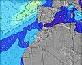 | 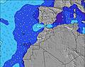 | 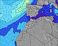 | 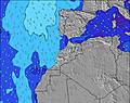 | 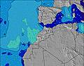 | 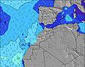 | 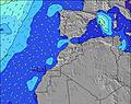 | ||||||||||||
Oleaje Altura (m) Dirección Período (s) | NW 7 | NW 7 | NW 7 | NW 7 | NW 8 | NW 8 | SW 4 | SW 4 | NW 6 | NNW 11 | NW 6 | NW 11 | NW 10 | NW 10 | NW 10 | NW 10 | NW 10 | NW 10 | NW 10 |
Gráfico Olas | |||||||||||||||||||
102 | 79 | 64 | 24 | 18 | 18 | 7 | 7 | 7 | 12 | 7 | 18 | 17 | 17 | 16 | 16 | 16 | 18 | 15 | |
Viento (km/h) | |||||||||||||||||||
Estado del Viento Viento de Mar Viento de Mar-Cruzado Cruzado Viento de Tierra-Cruzado Viento de Tierra Cristalino | cross-on | cross-on | on | cross-on | cross | cross | cross-on | on | on | on | cross-on | cross-on | cross-on | cross | cross-on | on | cross-on | cross-on | cross-on |
Marea alta | 2:00PM2.46m | 2:24AM2.36m | 2:37PM2.60m | 2:59AM2.46m | 3:12PM2.72m | ||||||||||||||
Marea baja | 8:18PM0.54m | 8:25AM0.57m | 8:54PM0.42m | 9:00AM0.45m | 9:28PM0.33m | ||||||||||||||
— | — | — | — | 6:31 | — | — | — | — | — | — | — | 6:31 | — | — | — | — | — | — | |
— | 8:31 | — | — | — | — | — | — | — | 8:30 | — | — | — | — | — | — | — | 8:30 | — | |
mm | — | — | — | — | — | — | — | — | — | — | — | — | — | — | — | — | — | — | — |
Temp. °C | 30 | 29 | 27 | 23 | 22 | 22 | 24 | 24 | 24 | 23 | 22 | 21 | 21 | 20 | 23 | 24 | 24 | 24 | 23 |
Enfriamiento °C | 26 | 28 | 27 | 22 | 23 | 23 | 24 | 24 | 24 | 24 | 25 | 23 | 23 | 22 | 26 | 24 | 24 | 25 | 24 |
Oleaje 1 Altura (m) Dirección Período (s) | NW 9 | NW 9 | NNE 7 | NW 7 | NNE 7 | NW 6 | NW 6 | NW 6 | NW 6 | NW 6 | WSW 4 | WNW 5 | WNW 5 | WNW 5 | WNW 5 | NW 10 | NW 10 | NW 10 | NW 5 |
20 | 20 | 15 | 23 | 16 | 6 | 6 | 5 | 5 | 5 | 3 | 3 | 5 | 9 | 8 | 16 | 16 | 15 | 12 | |
Oleaje 2 Altura (m) Dirección Período (s) | — | NNE 7 | WNW 9 | N 7 | NW 6 | NNE 7 | WNW 8 | WNW 9 | WNW 8 | WNW 8 | NW 6 | NW 11 | NW 10 | NW 10 | NW 10 | WNW 8 | WNW 11 | WNW 11 | NW 10 |
— | 4 | 8 | 24 | 15 | 9 | 7 | 7 | 7 | 7 | 5 | 18 | 17 | 17 | 16 | 6 | 13 | 12 | 15 | |
Oleaje 3 Altura (m) Dirección Período (s) | — | — | N 13 | NW 8 | NW 8 | NW 8 | N 5 | N 4 | NW 11 | NNW 11 | WNW 8 | WNW 8 | WNW 8 | WNW 8 | WNW 8 | WNW 11 | WNW 8 | WNW 8 | WNW 11 |
— | — | 3 | 18 | 18 | 18 | 2 | 2 | 5 | 12 | 7 | 7 | 7 | 6 | 6 | 13 | 6 | 6 | 12 | |
Olas de Viento Altura (m) Dirección Período (s) | NW 7 | NW 7 | NW 7 | WSW 2 | SW 4 | SW 4 | SW 4 | SW 4 | WSW 4 | WSW 4 | — | SW 4 | WSW 4 | — | — | WNW 5 | WNW 5 | WNW 5 | — |
102 | 79 | 64 | 1 | 10 | 7 | 7 | 7 | 6 | 3 | — | 4 | 1 | — | — | 8 | 15 | 18 | — | |
Viento del Tierra o Mar Limpio más proximo | |||||||||||||||||||
Distancia (km) | 343 | 277 | 181 | 71 | 236 | 236 | 236 | 236 | 236 | 246 | 220 | 236 | 220 | 98 | 343 | 509 | 339 | 569 | 510 |
Mejores Olas Previstas en Tangier to Rabat | |||||||||||||||||||
Mejores Olas Previstas en Morocco | |||||||||||||||||||
Busca-Olas Global | |||||||||||||||||||
- Map Icons:
 Break
Break Live Wave Height (m)
 Live Wind Speed (km/h)
 Surf Rating (10 Max)
 Ocean Swells (m)
- Wind Speed (km/h)
GRÁTIS! Un widget de Surf-Forecast.com para tu sitio
Este widget grátis de previsiones de surf y tiempo puede ser añadido a cualquier otro sitio y da un resumen de previsiones de olas para Moulay Bousselham. Solo necesita cortar y pegar el código HTML de abajo en su web. Puede elegir preferencias de idioma y de unidades (métricas o imperiales) para convenir a los usuarios de su sitio. Clica aquí para obtener el código.
 Nearest