
Previsiones:

Pronóstico Corto PlazoLluvia ligera (totál 5mm), cayendo mayormente el domingo por la mañana. Warm (max 26°C el sábado por la mañana, min 23°C el viernes por la noche). Mayormente vientos frescos. | ||||||||||||||||||
vie 24 | sábado 25 | domingo 26 | ||||||||||||||||
6 PM | 9 PM | 12 AM | 3 AM | 6 AM | 9 AM | 12 PM | 3 PM | 6 PM | 9 PM | 12 AM | 3 AM | 6 AM | 9 AM | 12 PM | 3 PM | 6 PM | 9 PM | |
Mapa de Altura de Olas | 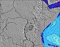 | 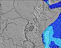 | 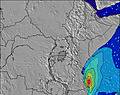 | 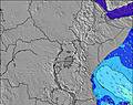 | 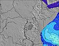 | 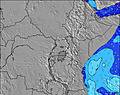 | 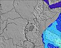 | |||||||||||
Oleaje Altura (m) Dirección Período (s) | SE 7 | SE 8 | SE 8 | SE 8 | SE 8 | ESE 8 | ESE 8 | SE 9 | ESE 9 | ESE 9 | SE 9 | SE 9 | SE 9 | SE 9 | SE 8 | SE 8 | SE 8 | SE 8 |
Gráfico Olas | ||||||||||||||||||
189 | 223 | 284 | 329 | 322 | 315 | 322 | 429 | 352 | 460 | 492 | 560 | 548 | 493 | 479 | 481 | 470 | 447 | |
Viento (km/h) | ||||||||||||||||||
Estado del Viento Viento de Mar Viento de Mar-Cruzado Cruzado Viento de Tierra-Cruzado Viento de Tierra Cristalino | cross | cross | cross | cross | cross-off | cross | cross | cross | cross | cross | cross | cross | cross | cross | cross | cross | cross | cross-on |
Marea alta | 1:17AM2.03m | 1:41PM2.68m | 2:30AM2.17m | 2:38PM2.84m | ||||||||||||||
Marea baja | 7:19PM1.31m | 6:46AM1.34m | 8:29PM1.15m | 7:59AM1.25m | ||||||||||||||
— | — | — | — | 6:30 | — | — | — | — | — | — | — | 6:30 | — | — | — | — | — | |
6:24 | — | — | — | — | — | — | — | 6:24 | — | — | — | — | — | — | — | 6:24 | — | |
mm | — | — | — | — | — | — | — | — | — | — | — | — | — | 1 | — | — | — | — |
Temp. °C | 25 | 24 | 24 | 24 | 23 | 25 | 26 | 26 | 26 | 25 | 24 | 24 | 24 | 25 | 26 | 26 | 25 | 24 |
Enfriamiento °C | 24 | 23 | 23 | 24 | 24 | 25 | 25 | 25 | 26 | 24 | 23 | 23 | 24 | 23 | 23 | 23 | 23 | 23 |
Oleaje 1 Altura (m) Dirección Período (s) | S 10 | S 10 | S 10 | S 10 | SE 8 | ESE 8 | ESE 8 | SE 9 | ESE 9 | ESE 9 | ESE 9 | E 15 | — | ESE 8 | — | — | — | E 14 |
2 | 2 | 2 | 2 | 322 | 315 | 322 | 429 | 352 | 426 | 426 | 4 | — | 368 | — | — | — | 4 | |
Oleaje 2 Altura (m) Dirección Período (s) | — | E 14 | — | — | S 10 | S 10 | S 10 | S 9 | — | — | — | — | — | — | — | — | — | — |
— | 4 | — | — | 2 | 2 | 2 | 1 | — | — | — | — | — | — | — | — | — | — | |
Oleaje 3 Altura (m) Dirección Período (s) | — | — | — | — | — | — | — | — | — | — | — | — | — | — | — | — | — | — |
— | — | — | — | — | — | — | — | — | — | — | — | — | — | — | — | — | — | |
Olas de Viento Altura (m) Dirección Período (s) | SE 7 | SE 8 | SE 8 | SE 8 | — | — | — | — | S 4 | SE 9 | SE 9 | SE 9 | SE 9 | SE 9 | SE 8 | SE 8 | SE 8 | SE 8 |
189 | 223 | 284 | 329 | — | — | — | — | 24 | 460 | 492 | 560 | 548 | 493 | 479 | 481 | 470 | 447 | |
Viento del Tierra o Mar Limpio más proximo | ||||||||||||||||||
Distancia (km) | 2457 | 2439 | 2439 | 2439 | 296 | 187 | 187 | 187 | 2522 | 1753 | 1753 | 1753 | 296 | 1753 | 1753 | 1753 | 2458 | 2458 |
Mejores Olas Previstas en Kenya | ||||||||||||||||||
Mejores Olas Previstas en Kenya | ||||||||||||||||||
Busca-Olas Global | ||||||||||||||||||
- Map Icons:
 Break
Break Live Wave Height (m)
 Live Wind Speed (km/h)
 Surf Rating (10 Max)
 Ocean Swells (m)
- Wind Speed (km/h)
GRÁTIS! Un widget de Surf-Forecast.com para tu sitio
Este widget grátis de previsiones de surf y tiempo puede ser añadido a cualquier otro sitio y da un resumen de previsiones de olas para Mombasa Channel. Solo necesita cortar y pegar el código HTML de abajo en su web. Puede elegir preferencias de idioma y de unidades (métricas o imperiales) para convenir a los usuarios de su sitio. Clica aquí para obtener el código.
 Nearest