

Misquamicut State Beach Surf Guide
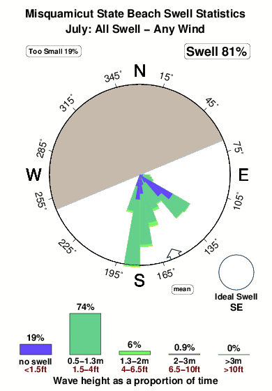
Misquamicut State Beach in Rhode Island is a fairly exposed beach break that is often working and works all around the year. Offshore winds blow from the north northwest. Most of the surf here comes from groundswells and the ideal swell direction is from the southeast. Good surf at all stages of the tide. When the surf is up, crowds are likely
Misquamicut State Beach Spot Info
| Type: | Rating: | Reliability: | Todays Sea Temp*: |
|---|---|---|---|
| very consistent | 19.3°C*ocean temperature recorded from satellite |
Surfing Misquamicut State Beach:
The best conditions reported for surf at Misquamicut State Beach occur when a Southeast swell combines with an offshore wind direction from the North-northwest.

Energía de Olas (poder): 12 horas


Misquamicut State Beach Surf:
Monday, 20 July 2026, 08:57 Local time| lunes 20 | ||||
| 5AM | 8AM | 11AM | 2PM | |
| Wave (m) | ||||
| Período (s) | 8 | 8 | 8 | 7 |
| Viento (km/h) | ||||
| Estado del Viento | off | off | glass | cross- on |
- /breaks/Misquamicut-State-Beach/forecasts/latest
Misquamicut State Beach Surf Guide
Misquamicut State Beach in Rhode Island is a fairly exposed beach break that is often working and works all around the year. Offshore winds blow from the north northwest. Most of the surf here comes from groundswells and the ideal swell direction is from the southeast. Good surf at all stages of the tide. When the surf is up, crowds are likely
Misquamicut State Beach Spot Info
Type: Rating: Reliability: Todays Sea Temp*:  Beach
Beach 3
3very consistent 19.3°C*ocean temperature recorded from satelliteSurfing Misquamicut State Beach:
The best conditions reported for surf at Misquamicut State Beach occur when a Southeast swell combines with an offshore wind direction from the North-northwest.
Energía de Olas (poder): 12 horas
Usa la barra de navegación de arriba para ver la temperatura del mar en Misquamicut State Beach, fotografías Misquamicut State Beach, previsiones detalladas de olas para Misquamicut State Beach, vientos y previsión del tiempo, webcams para Misquamicut State Beach, viento actual desde estaciones meteorológicas en Rhode Island y predicciones de marea para Misquamicut State Beach. Las mapas de olas para United States enseñarán un mapa grande de United States y los mares que rodean. Los mapas de olas pueden ser animadas para mostrar diferentes componentes de olas, la altura de ola, la energía de ola, el período, junto con previsiones de viento y del tiempo. Previsiones actuales del tiempo y del estado del mar provienen de boyas marinas de United States, del barcos que transitan en la zona y de estaciones meteorológicas costeras. Cada página de previsiones tiene un Busca-Olas Regional y Global para localizar las mejores condiciones para surfear en el área de Misquamicut State Beach.
Misquamicut State Beach Surf:
Monday, 20 July 2026, 08:57 Local timelunes 20 5AM 8AM 11AM 2PM Wave (m) Período (s) 8 8 8 7 Viento (km/h) Estado del Viento off off glass cross-
on- /breaks/Misquamicut-State-Beach/forecasts/latest
- /breaks/Misquamicut-State-Beach/forecasts/latest/six_day
Misquamicut State Beach Surf Guide
Misquamicut State Beach in Rhode Island is a fairly exposed beach break that is often working and works all around the year. Offshore winds blow from the north northwest. Most of the surf here comes from groundswells and the ideal swell direction is from the southeast. Good surf at all stages of the tide. When the surf is up, crowds are likely
Misquamicut State Beach Spot Info
Type: Rating: Reliability: Todays Sea Temp*: Beach3very consistent 19.3°C*ocean temperature recorded from satelliteSurfing Misquamicut State Beach:
The best conditions reported for surf at Misquamicut State Beach occur when a Southeast swell combines with an offshore wind direction from the North-northwest.
Energía de Olas (poder): 12 horas
Usa la barra de navegación de arriba para ver la temperatura del mar en Misquamicut State Beach, fotografías Misquamicut State Beach, previsiones detalladas de olas para Misquamicut State Beach, vientos y previsión del tiempo, webcams para Misquamicut State Beach, viento actual desde estaciones meteorológicas en Rhode Island y predicciones de marea para Misquamicut State Beach. Las mapas de olas para United States enseñarán un mapa grande de United States y los mares que rodean. Los mapas de olas pueden ser animadas para mostrar diferentes componentes de olas, la altura de ola, la energía de ola, el período, junto con previsiones de viento y del tiempo. Previsiones actuales del tiempo y del estado del mar provienen de boyas marinas de United States, del barcos que transitan en la zona y de estaciones meteorológicas costeras. Cada página de previsiones tiene un Busca-Olas Regional y Global para localizar las mejores condiciones para surfear en el área de Misquamicut State Beach.
Misquamicut State Beach Surf:
Monday, 20 July 2026, 08:57 Local timelunes 20 5AM 8AM 11AM 2PM Wave (m) Período (s) 8 8 8 7 Viento (km/h) Estado del Viento off off glass cross-
on- /breaks/Misquamicut-State-Beach/forecasts/latest
Misquamicut State Beach Surf Guide
Misquamicut State Beach in Rhode Island is a fairly exposed beach break that is often working and works all around the year. Offshore winds blow from the north northwest. Most of the surf here comes from groundswells and the ideal swell direction is from the southeast. Good surf at all stages of the tide. When the surf is up, crowds are likely
Misquamicut State Beach Spot Info
Type: Rating: Reliability: Todays Sea Temp*: Beach3very consistent 19.3°C*ocean temperature recorded from satelliteSurfing Misquamicut State Beach:
The best conditions reported for surf at Misquamicut State Beach occur when a Southeast swell combines with an offshore wind direction from the North-northwest.
Energía de Olas (poder): 12 horas
Usa la barra de navegación de arriba para ver la temperatura del mar en Misquamicut State Beach, fotografías Misquamicut State Beach, previsiones detalladas de olas para Misquamicut State Beach, vientos y previsión del tiempo, webcams para Misquamicut State Beach, viento actual desde estaciones meteorológicas en Rhode Island y predicciones de marea para Misquamicut State Beach. Las mapas de olas para United States enseñarán un mapa grande de United States y los mares que rodean. Los mapas de olas pueden ser animadas para mostrar diferentes componentes de olas, la altura de ola, la energía de ola, el período, junto con previsiones de viento y del tiempo. Previsiones actuales del tiempo y del estado del mar provienen de boyas marinas de United States, del barcos que transitan en la zona y de estaciones meteorológicas costeras. Cada página de previsiones tiene un Busca-Olas Regional y Global para localizar las mejores condiciones para surfear en el área de Misquamicut State Beach.
Misquamicut State Beach Surf:
Monday, 20 July 2026, 08:57 Local timelunes 20 5AM 8AM 11AM 2PM Wave (m) Período (s) 8 8 8 7 Viento (km/h) Estado del Viento off off glass cross-
onTide Times:
Para Weekapaug Point, Block Island Sound, Rhode Island, a %{dist} %{km} de %{location}.
PROXIMA ES A LAS (hora local) quedan marea alta marea baja Misquamicut State Beach Tide Times and Tide Chart
Live Weather:
At Westerly Airport, 3 km from Misquamicut State Beach.
calm
(km/h)
ClearAir temperature
15.0°CCurrent weather near Misquamicut State Beach
Buoy Data:
At Block Island, RI, 42 miles from Misquamicut State Beach.
3AM 4AM 5AM 6AM Antigüedad de datos 4 hr 3 hr 2 hr 1 hr Altura de Olas (m) 

Período Dominante (s) 8 8 8 8 Overall Misquamicut State Beach Surf Consistency and Wind Distribution in julio
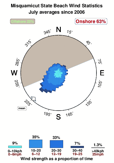


Wind stats for Misquamicut State Beach: see the variation in direction and stength by month.
Fotos de Surf
de la galeríaContornos: Carreteras y Ríos: Selecciona un spot desde el menú 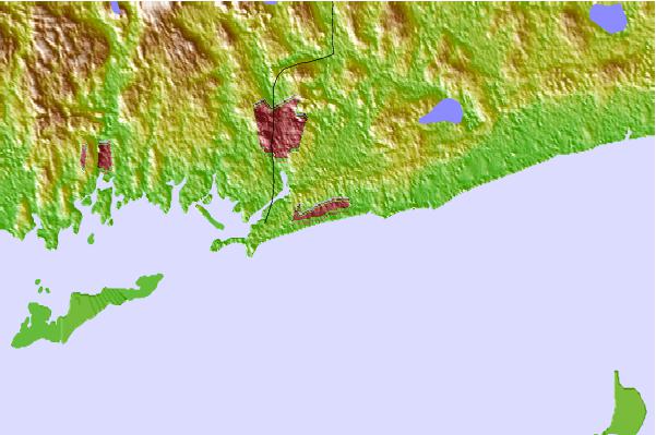


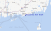
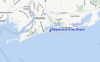
Usa este mapa para navegar hacia las playas de surf de Rhode Island y estaciones de marea cercanas de Misquamicut State Beach
Spots de Surf más cercanos a Misquamicut State Beach:
(Clica la ubicación para más detalles)- Closest spot2 mi
- Second closest spot2 mi
- Third closest spot3 mi
- Fourth closest spot4 mi
- Fifth closest spot4 mi
Boyas marinas más cercanas a Misquamicut State Beach:
- Closest Boya Marinas42 mi
- Second closest Boya Marinas46 mi
- Third closest Boya Marinas47 mi
- Fourth closest Boya Marinas84 mi
- Fifth closest Boya Marinas84 mi
Estaciones de marea más cercanas a Misquamicut State Beach:
- Closest estación de mareaWeekapaug Point, Block Island Sound2 mi
- Second closest estación de mareaWatch Hill Point4 mi
- Third closest estación de mareaWesterly, Pawcatuck River4 mi
- Fourth closest estación de mareaStonington, Fishers Island Sound6 mi
- Fifth closest estación de mareaCharlestown9 mi
Airports
- The closest passenger airport to Misquamicut State Beach is Theodore Francis Green State (Providence) Airport (PVD) in USA, 54 km (34 miles) away (directly).
- The second nearest airport to Misquamicut State Beach is North Central State (Smithfield) Airport (SFZ), also in USA, 71 km (44 miles) away.
- Third is Hartford Brainard Airport (HFD) in USA, 85 km (53 miles) away.
- The Francis S Gabreski (West Hampton Beach) Airport (FOK) in USA is 88 km (55 miles) away.
- Bradley International (Windsor Locks) Airport (BDL), also in USA is the fifth nearest airport to Misquamicut State Beach and is 101 km (63 miles) away.

- /breaks/Misquamicut-State-Beach/forecasts/latest

 Nearest