

Maximus Point and Town Lefts Surf Guide
Maximus Point and Town Lefts in - is a quite exposed point break. The best time of year for waves is autumn. Offshore winds blow from the northeast. Windswells are much more typical than groudswells and the best wave direction is from the south.Surfers ride left hand point. Rarely crowded here. Watch out for rocks.
Maximus Point and Town Lefts Spot Info
| Type: | Rating: | Reliability: | Todays Sea Temp*: |
|---|---|---|---|
| rarely breaks | 27.9°C*ocean temperature recorded from satellite |
Surfing Maximus Point and Town Lefts:
The best conditions reported for surf at Maximus Point and Town Lefts occur when a South swell combines with an offshore wind direction from the Northeast.

Energía de Olas (poder): 12 horas


Maximus Point and Town Lefts Surf:
Thursday, 16 July 2026, 20:02 Local time| jueves 16 | vie | |||
| 5PM | 8PM | 11PM | 2AM | |
| Wave (m) | ||||
| Período (s) | 7 | 7 | 7 | 7 |
| Viento (km/h) | ||||
| Estado del Viento | cross- off |
cross- off |
cross- off |
cross- off |
- /breaks/Maximus-Point-and-Town-Lefts/forecasts/latest
Maximus Point and Town Lefts Surf Guide
Maximus Point and Town Lefts in - is a quite exposed point break. The best time of year for waves is autumn. Offshore winds blow from the northeast. Windswells are much more typical than groudswells and the best wave direction is from the south.Surfers ride left hand point. Rarely crowded here. Watch out for rocks.
Maximus Point and Town Lefts Spot Info
Type: Rating: Reliability: Todays Sea Temp*:  Point
Point 3
3rarely breaks 27.9°C*ocean temperature recorded from satelliteSurfing Maximus Point and Town Lefts:
The best conditions reported for surf at Maximus Point and Town Lefts occur when a South swell combines with an offshore wind direction from the Northeast.
Energía de Olas (poder): 12 horas
Usa la barra de navegación de arriba para ver la temperatura del mar en Maximus Point and Town Lefts, fotografías Maximus Point and Town Lefts, previsiones detalladas de olas para Maximus Point and Town Lefts, vientos y previsión del tiempo, webcams para Maximus Point and Town Lefts, viento actual desde estaciones meteorológicas en Caribbean y predicciones de marea para Maximus Point and Town Lefts. Las mapas de olas para Montserrat enseñarán un mapa grande de Montserrat y los mares que rodean. Los mapas de olas pueden ser animadas para mostrar diferentes componentes de olas, la altura de ola, la energía de ola, el período, junto con previsiones de viento y del tiempo. Previsiones actuales del tiempo y del estado del mar provienen de boyas marinas de Montserrat, del barcos que transitan en la zona y de estaciones meteorológicas costeras. Cada página de previsiones tiene un Busca-Olas Regional y Global para localizar las mejores condiciones para surfear en el área de Maximus Point and Town Lefts.
Maximus Point and Town Lefts Surf:
Thursday, 16 July 2026, 20:02 Local timejueves 16 vie 5PM 8PM 11PM 2AM Wave (m) Período (s) 7 7 7 7 Viento (km/h) Estado del Viento cross-
offcross-
offcross-
offcross-
off- /breaks/Maximus-Point-and-Town-Lefts/forecasts/latest
- /breaks/Maximus-Point-and-Town-Lefts/forecasts/latest/six_day
Maximus Point and Town Lefts Surf Guide
Maximus Point and Town Lefts in - is a quite exposed point break. The best time of year for waves is autumn. Offshore winds blow from the northeast. Windswells are much more typical than groudswells and the best wave direction is from the south.Surfers ride left hand point. Rarely crowded here. Watch out for rocks.
Maximus Point and Town Lefts Spot Info
Type: Rating: Reliability: Todays Sea Temp*: Point3rarely breaks 27.9°C*ocean temperature recorded from satelliteSurfing Maximus Point and Town Lefts:
The best conditions reported for surf at Maximus Point and Town Lefts occur when a South swell combines with an offshore wind direction from the Northeast.
Energía de Olas (poder): 12 horas
Usa la barra de navegación de arriba para ver la temperatura del mar en Maximus Point and Town Lefts, fotografías Maximus Point and Town Lefts, previsiones detalladas de olas para Maximus Point and Town Lefts, vientos y previsión del tiempo, webcams para Maximus Point and Town Lefts, viento actual desde estaciones meteorológicas en Caribbean y predicciones de marea para Maximus Point and Town Lefts. Las mapas de olas para Montserrat enseñarán un mapa grande de Montserrat y los mares que rodean. Los mapas de olas pueden ser animadas para mostrar diferentes componentes de olas, la altura de ola, la energía de ola, el período, junto con previsiones de viento y del tiempo. Previsiones actuales del tiempo y del estado del mar provienen de boyas marinas de Montserrat, del barcos que transitan en la zona y de estaciones meteorológicas costeras. Cada página de previsiones tiene un Busca-Olas Regional y Global para localizar las mejores condiciones para surfear en el área de Maximus Point and Town Lefts.
Maximus Point and Town Lefts Surf:
Thursday, 16 July 2026, 20:02 Local timejueves 16 vie 5PM 8PM 11PM 2AM Wave (m) Período (s) 7 7 7 7 Viento (km/h) Estado del Viento cross-
offcross-
offcross-
offcross-
off- /breaks/Maximus-Point-and-Town-Lefts/forecasts/latest
Maximus Point and Town Lefts Surf Guide
Maximus Point and Town Lefts in - is a quite exposed point break. The best time of year for waves is autumn. Offshore winds blow from the northeast. Windswells are much more typical than groudswells and the best wave direction is from the south.Surfers ride left hand point. Rarely crowded here. Watch out for rocks.
Maximus Point and Town Lefts Spot Info
Type: Rating: Reliability: Todays Sea Temp*: Point3rarely breaks 27.9°C*ocean temperature recorded from satelliteSurfing Maximus Point and Town Lefts:
The best conditions reported for surf at Maximus Point and Town Lefts occur when a South swell combines with an offshore wind direction from the Northeast.
Energía de Olas (poder): 12 horas
Usa la barra de navegación de arriba para ver la temperatura del mar en Maximus Point and Town Lefts, fotografías Maximus Point and Town Lefts, previsiones detalladas de olas para Maximus Point and Town Lefts, vientos y previsión del tiempo, webcams para Maximus Point and Town Lefts, viento actual desde estaciones meteorológicas en Caribbean y predicciones de marea para Maximus Point and Town Lefts. Las mapas de olas para Montserrat enseñarán un mapa grande de Montserrat y los mares que rodean. Los mapas de olas pueden ser animadas para mostrar diferentes componentes de olas, la altura de ola, la energía de ola, el período, junto con previsiones de viento y del tiempo. Previsiones actuales del tiempo y del estado del mar provienen de boyas marinas de Montserrat, del barcos que transitan en la zona y de estaciones meteorológicas costeras. Cada página de previsiones tiene un Busca-Olas Regional y Global para localizar las mejores condiciones para surfear en el área de Maximus Point and Town Lefts.
Maximus Point and Town Lefts Surf:
Thursday, 16 July 2026, 20:02 Local timejueves 16 vie 5PM 8PM 11PM 2AM Wave (m) Período (s) 7 7 7 7 Viento (km/h) Estado del Viento cross-
offcross-
offcross-
offcross-
offTide Times:
Para Belham Valley Rivermouth, a %{dist} %{km} de %{location}.
PROXIMA ES A LAS (hora local) quedan marea alta marea baja Maximus Point and Town Lefts Tide Times and Tide Chart
Live Weather:
At John Osborne Airport, 11 km from Maximus Point and Town Lefts.
wind obs. (30 kph from 130 degs) was rejected
(km/h)
Dry and partly cloudyAir temperature
27°CCurrent weather near Maximus Point and Town Lefts
Buoy Data:
At Eastern Caribbean Buoy, 87 miles from Maximus Point and Town Lefts.
3PM 4PM 5PM 6PM Antigüedad de datos 4 hr 3 hr 2 hr 1 hr Altura de Olas (m) 


Período Promedia (s) 4.8 4.8 4.6 4.4 Overall Maximus Point and Town Lefts Surf Consistency and Wind Distribution in julio


Wind stats for Maximus Point and Town Lefts: see the variation in direction and stength by month.
Fotos de Surf
de la galeríaContornos: Carreteras y Ríos: Selecciona un spot desde el menú 


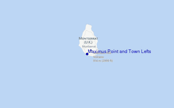
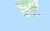
Usa este mapa para navegar hacia las playas de surf de Caribbean y estaciones de marea cercanas de Maximus Point and Town Lefts
Spots de Surf más cercanos a Maximus Point and Town Lefts:
(Clica la ubicación para más detalles)- Closest spot3 mi
- Second closest spot4 mi
- Third closest spot4 mi
- Fourth closest spot4 mi
- Fifth closest spot5 mi
Boyas marinas más cercanas a Maximus Point and Town Lefts:
- Closest Boya Marinas87 mi
- Second closest Boya Marinas201 mi
- Third closest Boya Marinas241 mi
- Fourth closest Boya Marinas285 mi
- Fifth closest Boya Marinas296 mi
Estaciones de marea más cercanas a Maximus Point and Town Lefts:
- Closest estación de mareaSaint Johns, Antigua39 mi
- Second closest estación de mareaPointe-Noire42 mi
- Third closest estación de mareaSainte-Rose42 mi
- Fourth closest estación de mareaBouillante48 mi
- Fifth closest estación de mareaLamentin48 mi
Airports
- The closest passenger airport to Maximus Point and Town Lefts is V C Bird International (Antigua) Airport (ANU) in Leeward Islands, 67 km (42 miles) away (directly).
- The second nearest airport to Maximus Point and Town Lefts is Le Raizet (Pointe-a-pitre) Airport (PTP) in Antilles, 85 km (53 miles) away.
- Third is Robert L Bradshaw (Basse Terre) Airport (SKB) in St. Kitts & Nevis, 89 km (55 miles) away.
- F D Roosevelt (Oranjestad) Airport (EUX) in Antilles is 123 km (76 miles) away.
- Gustavia/st.barthel (St.-barthelemy) Airport (SBH), also in Antilles is the fifth nearest airport to Maximus Point and Town Lefts and is 152 km (94 miles) away.
- /breaks/Maximus-Point-and-Town-Lefts/forecasts/latest

 Nearest